Find Your Daily Voice
 47°
47°
Severe Weather Threat Upgraded For Region: Here's Time Frame For Approaching Thunderstorms
The threat of severe weather from an approaching round of thunderstorms has just been upgraded for most of the region.
Storm activity is expected from west to east from 6 p.m. to 11 p.m. Saturday, April 1.
The area covers New York City, Long Island, Westchester, Rockland, Putnam, and Orange counties, and Fairfield, New Haven, Middlesex, and New London counties in Connecticut. (See the image above.)
"The Storm Prediction Center has placed the area in an enhanced risk of severe thunderstorms this evening," the National Weather Service said in a statement issued mid-Saturday afternoon. "…
Caught In Historic Blizzard, NY Mom, Kids Find Overnight Refuge At Target Store (Photos)
Jessica Sypniewski was a mom on a mission: to find some place, any place, where she and her boyfriend, along with their 11-year-old daughter and 7-year-old son, could take refuge from the blinding snow and howling winds of a historic, deadly blizzard that had barreled down in western New York just before Christmas, and lasting days.
The 33-year-old Erie County resident, of West Seneca, told Daily Voice the family had set out Friday morning, Dec. 23, to pick up a relative on the other side of town. On the way back, however, they found themselves caught in one of the worst winter storms the r…
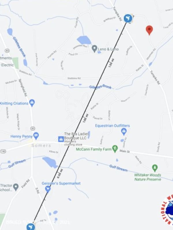
Tornado Touches Down In Connecticut Leaving Trail Of Downed Trees, Destroyed Vehicles
A tornado touched down in Connecticut during a severe thunderstorm leaving behind damaged trees, missing shingles, and two destroyed vehicles.
The tornado rated an EF-0 (the weakest of the five levels on the Enhanced Fujita Scale), touched between 6:11 p.m. and 6:18 p.m., Sunday, July 18, in the Town of Somers, located in Tolland County near the Massachusetts border, according to the National Weather Service.
The tornado was first reported by amateur radio operators on a tip from a trained Skywarn Weather Spotter, the service said.
The tornado, which traveled for about 1.9 miles, first tou…
Severe Thunderstorm Watch In Effect For Most Of Region
A Severe Thunderstorm Watch is now in effect for much of the region.
It lasts until 10 p.m. Wednesday, June 30, and covers Westchester, Rockland, Putnam, Dutchess, Orange, Ulster, Sullivan, Greene, Columbia counties in New York, Fairfield, Hartford, Litchfield, New Haven, Tolland, New London, and Middlesex counties in Connecticut, and all of Massachusetts except Cape Cod, and northeast Pennsylvania. (See image above.)
Torrential rainfall is likely during storm activity. Quarter-sized hail, damaging winds, and frequent lightning are possible, along with power outages, the National …
Line Of Thunderstorms, Some Severe, Sweeping Through Region, With Gusty Winds, Hail Possible
A line of thunderstorms, some severe, is sweeping through the region from the west to the east on Tuesday afternoon, June 8.
Storm activity is expected to continue through the afternoon and evening.
Wind gusts up to 60 miles per hour and penny-sized hail are possible.
"There is the potential for heavy rainfall which may produce localized flash flooding," the National Weather Service said in a Hazardous Weather Statement on Tuesday. "Gusty winds and lightning strikes are also threats."
Wednesday, June 9 will be another hot, humid, and potentially stormy day, with partly sunn…
Strong To Severe Storms Will Bring Damaging Wind Gusts, Possible Tornadoes, Hail
A line of thunderstorms will sweep through the region, bringing the potential for severe weather.
The time frame for the storm system, which will be ignited by an approaching cold front, is late Wednesday afternoon, May 26 through Wednesday evening.
Damaging wind gusts, large hail, and a couple of tornadoes are possible, the National Weather Service said in a Hazardous Weather Outlook statement issued Wednesday.
"Strong to damaging wind gusts will be the main threat," the statement said.
The high temperature will shoot back up to the upper 80s to around the 90-deg…