Find Your Daily Voice
 63°
63°
Large Hail, Tornado Possible In DMV Region As Thunderstorms Return To The Area
Just as the region cleaned up from last week's rash of thunderstorms, a new batch of severe weather is heading toward the region.
Whipping winds approaching 70 mph are possible along with a chance of a tornado, hail, and flash flooding potentially hitting some parts of Washington, DC, Maryland, and Virginia on Monday, Aug. 14, forecasters are advising.
Hot and humid air paired with an approaching warm front will result in thunderstorms later today. Some storms may become severe, with damaging winds, large hail, and an isolated tornado all possible threats. #DCwx #MDwx #VAwx #WVwx pic.tw…
Here's Your Best Chance To Catch Upcoming Perseid Meteor Shower
The highly-anticipated Perseid meteor shower will return with a stunning sky show for viewers around the world.
Considered the most scenic meteor shower of the year, viewers can enjoy spectacular sights each July and August.
The shower became active on July 17, and the number of meteors increase every night until the shower's peak, on Saturday, Aug. 12, and Sunday, Aug. 13, according to Royal Museums Greenwich (RMG).
The best time to step outside for a sky-gaze? Head out in the early-morning hours, before sunset, the week before or after the August peak.
According to RMG, the m…
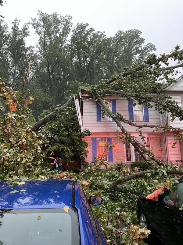
Tornado Watch Issued For Parts Of DMV, PA
The region is bracing for severe storms that are expected to smash through the region on Monday night.
A Tornado Watch has been issued by the National Weather Service for parts of Washington, DC, Maryland, Pennsylvania, and Virginia through 9 p.m. on Monday, Aug. 7, as the area is expected to be battered by thunderstorms.
Tornadoes are "likely," according to officials, with storms bringing ping pong-sized hail, and wind gusts approaching 75 mph.
🌪️A Tornado WATCH has been issued for @MontgomeryCoMD until 9p today. Keep an eye on the sky & monitor rapidly changing weather conditions…
Damaging Winds, Hail, Tornadoes Possible From Storms Heading To DMV Region
Severe weather is being tracked toward the region, forecasters are warning.
Showers and thunderstorms are expected to impact neighborhoods in Washington, DC, Maryland, and Virginia beginning on Sunday, Aug. 6 and into Monday, when things are expected to get worse before they get better.
Heads up #MoCo, we're about to get rocked soon. Rain should start moving in around 530-545 and the heavy stuff will hit soon after. Right now the storm should be moving out around 2 am. Be ready for power outages, trees/lines down. And severe traffic delays. #BePrepared pic.twitter.com/96w2Dkorp8 — Montg…
Storms Usher In Comfortable Air, But Not Without September Surprise
A cold front that accompanied a potent round of thunderstorms ended the first heat wave of the season.
Will there be another heat wave? The answer to that is not only yes, but later than what is typically normal.
In fact, it could happen in the Northeast right around Labor Day on Monday, Sept. 4, according to AccuWeather.com, which says the window for summery-type weather is "during the first week or two of September, slightly later than the historical average for the latest 90-degree day."
But for now, a refreshing blast of cooler air has arrived, with conditions on Sunday morning, July 3…