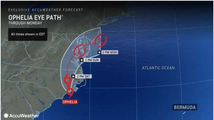
Ophelia made landfall near Emerald Isle, North Carolina, on Saturday morning, Sept. 23.
It's packed with 65-mile-per-hour winds and is moving at around 13 mph.
Isolated tornadoes are possible from the system.
"Ophelia will spread drenching downpours, strong gusts, pounding surf, and ocean, sound, and bay flooding northward along the Atlantic coast from North Carolina to New Jersey, southeastern New York, and southern New England into this weekend," according to AccuWeather.com. "Because of the close proximity of the system, impacts will be much more significant when compared to Hurricane Lee which passed offshore last week."
Ophelia will gradually weaken as it moves up the East Coast and is expected to be downgraded to a tropical depression before it reaches the Northeast, where maximum wind speeds should top off at around 40 to 45 mph, with the highest gusts expected to be highest along the coast, the National Weather Service said.
There will be rain throughout the day and evening on Saturday, the first day of autumn. Steady rai from the storm will develop later Saturday morning from south to north.
Thunderstorms are possible Saturday night and again Sunday afternoon and evening.
Around 2 to 4 inches of rainfall is expected from the storm with locally higher amounts.
"For this weekend, there is a low chance of flash flooding," the National Weather Service said. "For coastal portions, there will be potential for some coastal flooding."
The high temperature on Saturday will be in the mid-60s.
It will remain mostly cloudy Sunday, Sept. 24 with rain at times during the day and again at night. The high temperature will be in the upper 60s.
Rain and showers are likely on Monday morning before tapering off in the afternoon. It will be cloudy with the high temperature holding steady at around 60 degrees.
It will be partly sunny Tuesday, Sept. 26 with a high temperature in the low 60s.
Ophelia is the 15th named storm of the 2023 season.
In early August, the National Oceanic and Atmospheric Administration increased its prediction for named storms this year from 12 to 17 to 14 to 21.
The next storm name will be Philippe and will likely go to a new tropical system developing in the central Atlantic that the National Hurricane Center says is nearly certain to strengthen.
Check back to Daily Voice for updates.
Click here to follow Daily Voice Brentwood and receive free news updates.
