The time frame for the storm is overnight Monday evening, Feb. 12 into Tuesday afternoon, Feb. 13, according to the National Weather Service, which says travel could be "very difficult" during that time and "hazardous conditions could impact the Tuesday morning commute."
Precipitation is expected to begin as rain Monday night before changing over to a wintry mix a few hours before daybreak on Tuesday, with snow, which could be heavy at times, in inland areas, where a Winter Storm Watch is now in effect from 1 a.m. to 6 p.m. Tuesday.
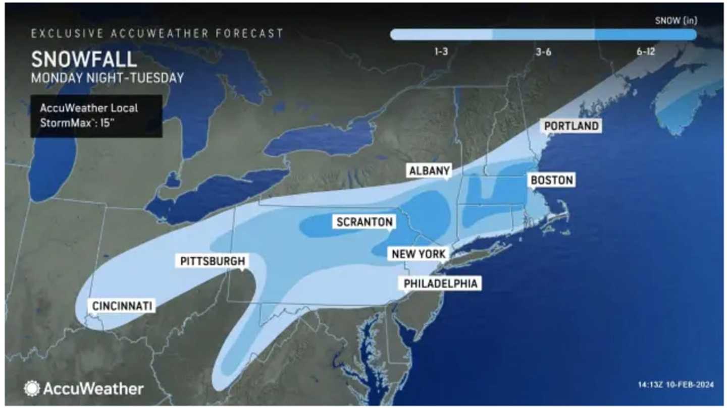
In the latest projections above released on Saturday, Feb. 10 by AccuWeather.com, a widespread 3 to 6 inches of snowfall is now expected for much of the Northeast (areas shown in Columbia blue). Locally higher amounts of around 10 inches are possible, the National Weather Service said.
A total of 6 to 12 inches (areas shown in the darkest shade of blue, are now expected to see 6 to 12 inches, including much of Massachusetts and Connecticut, and parts of the Catskills and Hudson Valley in interior New York.
In spots shown in sky blue, 1 to 3 inches are forecast.
Areas farthest south, including parts of New York City and Long Island are expected to see the least amount of snow, with about an inch expected with 2 inches possible in spots.
A rise in temperatures that started late in the week will continue on Sunday, Feb. 11, with a high temperature of around 50 degrees with mainly cloudy skies before a cooling trend starts into Monday.
There will be a mix of sun and clouds on Monday, with a high temperature in the mid-40s.
With the low temperature expected to drop to just below the freezing mark overnight into Tuesday, a widespread mix of rain, sleet, and snow is expected from the system, with mainly snow, heavy at times, in areas away from the coast.
Winds could gust as high as around 30 miles per hour Tuesday, leading to possible scattered power outages.
The current outlook for Valentine's Day on Wednesday, Feb. 14 calls for mostly sunny skies and a high temperature in the low to mid-30s.
Check back to Daily Voice for updates.
Click here to follow Daily Voice Brentwood and receive free news updates.