Find Your Daily Voice
Northwest Dutchess
Your Local News for Northwest Dutchess County, New York
Saturday, apr 27
45°
Follow
News
Schools
Business
Obituaries
Police & Fire
Weather
Lifestyle
Politics
Sports
Traffic
Real Estate
Tags
Jobs
Shop
Support Us
Northwest Dutchess
Follow
Find Your Daily Voice
News
Schools
Business
Obituaries
Police & Fire
Weather
Lifestyle
Politics
Sports
Traffic
Real Estate
Tags
Jobs
Shop
Support Us
Home
About us
All sites
Advertise with us
Contact us
Terms of use
Privacy policy
Code of ethics
Site Map
© 2024 Cantata Media
45°
Saturday, apr 27
Tag:
Weather Advisory
Weather
New Upcoming Storm Could Topple Trees, Cause Power Outages Across Region, Officials Warn
Now’s the time to charge those phones and find those flashlights. Central Hudson Gas & Electric is urging customers to prepare for possible power outages ahead of a new storm system expected to bring drenching rain and damaging winds to the region. The storm, which is being labeled as a "multi-hazard event" by the National Weather Service, is expected to arrive late Tuesday afternoon, Jan. 9, and increase in intensity Tuesday night into Wednesday morning, Jan. 10. Forecasters warned that heavy rain could bring between 2 and 4 inches of rainfall to some areas along with potentially…
News
Here's When Heavy Rain, Wind From Nicole Could Cause Power Outages, Central Hudson Warns
As Tropical Storm Nicole takes aim on the Northeast, Central Hudson Gas & Electric is warning Hudson Valley residents to be prepared for the potential for severe weather over the weekend. Currently, the projected path shows the possibility of strong wind gusts and rain as Nicole moves through the region on Friday, Nov. 11 in the afternoon through the evening and overnight into Saturday morning, Nov. 12, the company said. Though the exact path of the storm remains uncertain, current forecasts are calling for up to two inches of rain and wind gusts of up to 45 mph. Earlier r…
Weather
These Areas Will Get Most Snowfall From Storm With Strong Winds That Could Cause Power Outages
It will be time to "Spring Ahead" overnight, but first, a late-winter storm will plow through the region bringing damaging wind gusts that could cause power outages and a mix of rain, sleet and snow with some parts of the Northeast expected to see a foot of snow or more on Saturday, March 12. Areas in light blue in the first image above should see between 1 and 3 inches of snowfall, according to AccuWeather.com. Farther inland, in Columbia blue, 3 to 6 inches is forecast. Areas in blue should see 6 to 12 inches with some spots in upstate New York and northern New England (shown in dar…
Weather
Wind Advisory: 50 MPH Gusts During Round Of Storms Could Cause Power Outages
A strong cold front will be ushered in by a round of heavy thunderstorms with damaging wind gusts that could cause power outages. A Wind Advisory has been issued for the region from 6 p.m. Monday, March 7 until 4 a.m. Tuesday, March 8, the National Weather Service announced. Gusts of up to 50 miles per hour are possible during that time. "Gusty winds could blow around unsecured objects," the weather service said. "Tree limbs could be blown down and a few power outages may result." Earlier report - Weather Whiplash: Storms With Strong Wind Gusts Will Be Followed By New Chance…
Weather
Icy Mix Of Freezing Rain, Sleet, Snow Causes Hazardous Travel, Many School Closures
The arrival of a massive winter storm bringing a mix of snow, sleet and freezing rain has caused hazardous travel conditions and many school closures throughout the region on Friday, Feb. 25. The wide area where icy conditions are causing slippery travel conditions are shown in the first image above. A look at the types of precipitation by area on Friday, Feb. 25 are shown in the second image above: Rain/snow/ice (in pink), snow (blue), and rain/showers (green). Click on the second image above for a look at the types of precipitation the storm will bring, with rain in green, rain/snow…
Weather
New Storm System Could Bring Snow Squalls, Cause Hazardous Driving Conditions
A new storm system with the potential for snow squalls could cause hazardous driving conditions over the weekend, according to a brand-new advisory by the National Weather Service. After bands of heavy rain accompanied by gusty winds, skies will gradually clear Friday, Feb. 18, and the temperature will drop during the afternoon from a high in the mid to upper 50s to the mid 30s just before nightfall, with wind-chill values in the 20s. It will be mostly clear overnight with wind-chill values in the teens. Saturday, Feb. 19 will be breezy with clouds increasing and a high temperature in the …
Weather
Icy Conditions, Heavy, Wet Snow May Cause Service Interruptions, Central Hudson Warns
Central Hudson Gas & Electric Corp. has advised customers to prepare for possible service interruptions as a winter storm is expected to bring heavy snow and freezing rain to the region. The winter storm is expected to move through the Hudson Valley from the night of Thursday, Feb. 3, through Friday, Feb. 4, bringing a mix of freezing rain, sleet and snow. Related - Mix Of Freezing Rain, Sleet, Snow Will Be Followed By Sharp Drop In Temps, Dangerous Icing “We are keeping a close eye on the incoming storm and how it may impact our customers,” said Ryan Hawthorne, vice preside…
Weather
Strong Wind Gusts Up To 55 MPH Could Cause Power Outages
The rain has moved out but dangerous winds have rolled in with strong gusts that could cause power outages. A Wind Advisory is in effect from late Friday morning, April 30 until early Saturday morning, May 1. Sustained winds of between 25 to 35 miles per hour are expected through the day, with gusts up to 55 mph at times, according to the National Weather Service. "Gusty winds could blow around unsecured objects," the weather service said in a statement released early Friday. "Scattered trees and tree limbs could be blown down with power outages possible. "Use extra caution when driv…
Weather
Wind Advisory: Strong Gusts Up To 50 MPH Could Cause Power Outages
Windy weather is returning to the region. A Wind Advisory is in effect for the entire area from early Friday afternoon, March 26, and lasting into the early overnight hours of Saturday, March 27. Gusts up to 50 miles per hour are expected during that time, according to the National Weather Service. Winds could blow around unsecured objects and lead to downed tree limbs which could cause power outages. Tree limbs could be blown down, leading to scattered power outages. Showers will taper off by late Friday morning and clouds will give way to afternoon sunshine on Friday with the high temp…
Weather
Slippery Stretch: Mix Of Snow, Sleet, Freezing Rain Will Make Travel Dangerous At Times
One of the most active weather patterns in years will stay on display through the weekend and into next week. There will be more snow at times during that stretch, but sleet and ice could pose more significant threats, with the possibility of potentially major power outages from damage to utility lines and trees as well as treacherous travel. There will be a chance and snow and sleet Saturday evening, Feb. 13 through the overnight into Valentine's Day on Sunday, Feb. 14 as a storm system arrives. New snow and sleet accumulation of one inch and ice accumulation of one-ten…
Weather
New Snowfall Projections Released For Storm That Will Sweep Through Region
New snowfall projections have been released for a storm system that will sweep through the region, bringing up to several inches of accumulation for areas inland from New York City and Long Island. A look at the latest projected snowfall totals from Sunday afternoon, Jan. 3 into early Monday morning, Jan. 4 is shown in the image above, released early Sunday morning by the National Weather Service. A Winter Weather Advisory for much of the area from 9 a.m. Sunday into midnight Monday for areas north of I-287 and the Merritt Parkway in New York, Connecticut, and Massachusetts. Motorists in th…
News
Strong Winds May Cause Service Interruptions, Central Hudson Warns
Strong winds may knock out Central Hudson customer's electricity on Christmas Eve, Thursday, Dec. 24 and Christmas, Friday, Dec. 25, according to the utility company. “We know reliable electrical service is vital to our customers, especially during the Christmas holiday and at a time when we’re also navigating the COVID-19 pandemic,” said Ryan Hawthorne, Assistant Vice President of Electric Engineering and Operations at Central Hudson. “Our employees are prepared to work through the holiday, we have secured additional line crews and we are maintaining regular contact with local emerge…
Weather
Storm Watch: Winter Weather Advisory Issued For Much Of Area With Hazardous Travel Possible
A storm system that will sweep through will bring a wintry mix leading to icy travel conditions for much of the region. A Winter Weather Advisory is now in effect from 11 p.m. Wednesday, Feb. 5 through 10 a.m. Thursday, Feb. 6 for the areas shown in purple in the first image above. Ice accumulations of around one-tenth of an inch and sleet accumulation of up to one inch are expected during that time frame in areas north of I-287 in New York and the Merritt Parkway in Connecticut where hazardous conditions are possible for the Thursday morning commute. Little or no sleet accumulat…
Weather
Freezing Rain, Sleet Causing Slippery Conditions As Storm Arrives
Rain has started to move across the area and has transitioned to freezing rain and sleet farther inland even in some spots where the temperature is above the freezing mark as a complex storm has arrived in the region. The wintry mix has been reported after nightfall on Sunday, Dec. 29 mainly north of Interstate 84, especially in areas with high elevations. Freezing rain, sleet and snow will affect Dutchess, Ulster and Sullivan counties into Tuesday, Dec. 31. Winter Weather Advisories are in effect from 5 p.m. Sunday through 7 a.m. Tuesday, Dec. 31 for the counties shown in purple in …
Weather
Winter Weather Advisories Now In Effect For Much Of Region As Storm Nears
Click here for a new, updated story: Projected Snowfall Totals Increase For Powerful Storm System That Will Sweep Through Area As a powerful, quick-moving storm that will bring a mix of snow, sleet and freezing rain nears, Winter Weather Advisories have now been issued for much of the region. The advisories are in effect from 6 p.m. Monday, Dec. 16 until 6 p.m. Tuesday, Dec. 17 for the counties north of New York City and Long Island shown in purple in the first image above. Those traveling through the areas covered by the advisories should plan on slippery road conditions, the Na…
Weather
Projected Snowfall Totals Adjusted With Winter Weather Advisories Issued For Much Of Area
New Update: Here Are Latest Snowfall Projections, Time Frame For Storm Projected snowfall totals have been adjusted for the slow-moving storm system sweeping through the area, with higher amounts now projected farther south. The changeover from rain to snow will happen overnight Tuesday, Dec. 10 into Wednesday, Dec. 11. Winter Weather Advisories are now in effect for New York City and Long Island as well as Westchester and Fairfield counties from 3 a.m. to 11 a.m. on Wednesday. (See first image above.) Generally, 2-3 inches of snowfall is still being predicted for areas…
Weather
Projected Snowfall Totals Released For Storm From Overnight Tuesday Through Wednesday Morning
Click here for a new, updated story: Projected Snowfall Totals Adjusted With Winter Weather Advisories Issued For Much Of Area Projected snowfall totals have been released after rain turns to snow at the tail-end of a slow-moving storm system sweeping through the area. The changeover will happen overnight Tuesday, Dec. 10 into Wednesday, Dec. 11. Generally, 2-3 inches of snowfall is now predicted for areas south of I-84 in New York and Connecticut, including New York City and Long Island., according to the National Weather Service. (See first image above.) North of I-84, up …
Weather
Winter Weather Advisory Issued For Parts Of Region As Storm Approaches
As a strong storm system nears the Northeast, a Winter Weather Advisory has been issued for parts of the region far north and inland. Mixed precipitation including snow, sleet and freezing rain is expected for areas where the advisory is in effect, including western Ulster and Sullivan counties in the Hudson Valley and northern Litchfield in Connecticut. (See second image above.) Total snow and sleet accumulations of 2 to 4 inches and ice accumulations of a light glaze to up to a tenth of an inch is possible in those areas. The advisory is in effect from 10 p.m. Saturday, N…
Weather
Nor'easter Nears: Winter Weather Advisory Issued For Dutchess County
As a Nor'easter that will bring rain and wind to the entire area and sleet, freezing rain and ice farther inland approaches, a Winter Weather Advisory has been issued for much of the area. The weekend will end with another cold day on Sunday, Nov. 17. The high temperature will be in the upper 30s, but it will feel much colder, with the wind-chill factor between 15 and 25 degrees. The Winter Weather Advisory has been issued for the counties shown in purple in the first image above, including Dutchess, Orange, Sullivan and Ulster in New York and Litchfield in Connecticut. In those area…
Weather
Nor'easter Will Bring Soaking Rainfall, Strong Winds That Could Cause Power Outages
Click here for an updated story: Wind Advisory: Gusts Up To 50 MPH Could Blow Down Limbs, Trees, Power Lines, Causing Outages The season's first Nor'easter will bring widespread soaking rainfall followed by gusty, strong winds that could cause power outages. The storm, which has developed off the Delmarva Peninsula, is intensifying as it moves north, will arrive Wednesday afternoon, Oct. 16 and continue overnight before ending Thursday morning, Oct. 17. Preliminary forecast rainfall amounts are between 2 and 3 inches with locally heavier amounts. Widespread flooding is …
News
Central Hudson Issues Extreme Heat, Severe Storm Advisory To Customers
With extreme heat and heavy rain expected to hit the area, Central Hudson is warning customers to be wary of a summer storm. Thunderstorms and heavy rainfall are expected mid-week, followed by high temperatures and humidity with heat indexes in the upper 90s and potentially exceeding 100 degrees on Friday and through the weekend, the utility company noted. "Customers of Central Hudson Gas & Electric Corp. are urged to prepare for these weather systems by taking precautions in the event of electric service interruptions brought about by storms and conserving energy while staying cool dur…
Police & Fire
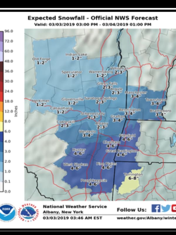
Here Are Latest Projected Snowfall Totals For Latest Storm
The latest projected snowfall totals have been released for the quick-moving storm that will sweep through the area and cause hazardous conditions for those traveling Sunday night into the Monday morning commute. It is now expected to bring about 4 to 6 inches of accumulation to Dutchess. (See first image above.) A Winter Storm Advisory will be in effect from 4 p.m. Sunday, March 3 until 10 a.m. Monday, March 4 in Dutches. Sunday will start off partly sunny before clouds roll in on a day in which the high temperature will be around 40 degrees. There's a 50-50 chance of rain early in the af…
Weather
Winter Weather Advisory: Projected Snowfall Totals For Overnight Storm Increase
By the time a new round of storms sweeps through the area through the weekend and ending on Monday, March 4, up to a foot of snowfall is possible. The latest storm Friday night, March 1 and continuing through around 9 a.m. Saturday, March 2 will bring 3 to 5 inches of accumulation. A Winter Weather Advisory is now in effect from 10 p.m. Friday until noon Saturday. Saturday's high temperature will climb to nearly 40 degrees with wind gusts up to 20 miles per hour and a wind-chill factor between 20 and 30. The second storm of the weekend is expected to arrive late in the afternoon on Sunday…
Weather
High Wind Watch: Storm With Damaging Gusts Up To 60 MPH Could Cause Power Outages
A strong storm will bring heavy rain and powerful, damaging wind gusts of up to 60 miles per hour that could knock down tree limbs and cause power outages in the area over the weekend. A High Wind Watch is in effect for the region beginning Sunday night and continuing through much of the day on Monday. (See first image above.) The storm will arrive overnight Saturday into Sunday, Feb. 24 with up to a half-inch of new precipitation by daybreak Sunday. Rain will move in sometime after 10 p.m. Saturday. The overnight low will stay just above freezing to the south, but farther north,…
Weather
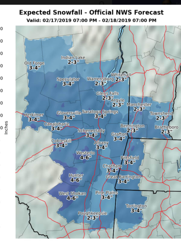
Snowfall Projections Released For Quick-Moving Storm That Will Sweep Through Area
Projected snowfall totals have been released for a quick-moving storm system that will sweep through the area overnight Sunday, Feb. 17 into Presidents Day on Monday, Feb. 18. The expected accumulation amounts range from 2 inches farther south to 4 inches farther north with ice accumulations of a light glaze also expected. (See first image above.) For a look at areas (in purple) where a Winter Weather Advisory is in effect from 9 p.m. Sunday, Feb. 17 until 10 a.m. Monday, Feb. 18, see the second image above. During that time, plan on slippery roads and hazardous conditions that could impac…
Weather
Eye On The Storms: Here's The Latest On Back-To-Back Rounds Of Snowfall
Old Man Winter is about to wake up from his nap. Get set for back-to-back storms that will make it look and feel like it really is the middle of January. The first storm will come overnight Thursday night into Friday morning with widespread 1 to 4 inches of accumulation, with the higher amounts farther north. For the latest snowfall projections, see the third image above. Travel will be hazardous due to poor visibility and snow-covered roads, particularly across the interior for the Friday morning commute, the National Weather Service said. Snow is expected to arrive around 11 …
News
Be Ready For Power Outages As Fourth Nor'easter Nears, Central Hudson Says
Spring has spring but wintry weather is here. With the fourth Nor’easter of the month expected to hit the region on Wednesday, bringing sleet, freezing rain, snow and strong wind gusts, Central Hudson Gas & Electric is warning customers to be prepared for potential power outages. Wind gusts are expected to reach up to 35 mph on Wednesday, with parts of the tri-state area getting upwards of 10 inches of snow. Charles Freni, the Senior Vice President of Customer Services and Transmission and Distribution for Central Hudson said that the company is “assembling a field force of approximate…
News
Travel Advisory Issued By Cuomo Includes Hudson Valley
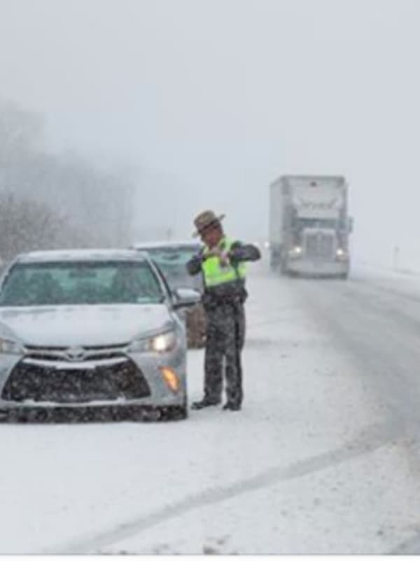
Related stories: Schools Announce Delayed Starts, Closures For Tuesday Eye Of The Storm: Nor'easter Brings Heavy Snow, Wind As the latest round of snow begins to stick, making for slow, slippery travel conditions, Gov. Andrew Cuomo has issued a travel advisory for portions of New York, including the Hudson Valley. "I caution all New Yorkers within the path of the storm to stay off the roads unless travel is absolutely necessary," Cuomo said Tuesday morning. "Driving conditions during and after the storm will be challenging and we want to ensure that our personnel are able to …
Weather
Latest Snowfall Projections Show Higher Amounts For Parts Of Area
Click here for an updated story: Winter Weather Advisory: Latest Info On New Nor'easter The latest snowfall projections for the third Nor'easter that will hit the area in a 12-day span once again show a range of 3 to 6 inches of accumulation for most of the tristate, but areas in Fairfield County along the coast could now see up to 8 inches, according to the National Weather Service. (See image above.) In addition, farther west and north, Orange County went from 3-4 projected inches Sunday morning to 4-6 in the new projections released late Sunday afternoon. Clouds will increase on Monda…
Weather
Weather Advisory Issued For Dutchess
Click here for an updated story: Developing Storm Expected To Bring New Round Of Accumulating Snow To Area A Winter Weather Advisory is in effect until 1 a.m. for parts of the Hudson Valley. With temperatures around freezing, a glaze of ice is possible with additional snow accumulations of up to 1 inch north of I-84, the National Weather Service said. The advisory covers Dutchess, Orange and Ulster counties. Light snow will accumulate up to an inch before gradually changing to rain in most places Sunday evening. There will be a chance of snow showers before 8 a.m. under mostly cloudy ski…
Weather
Black Ice Advisory Issued With Melting Snow Refreezing
With temperatures falling into the lower 20s and teens and standing water from melted snow freezing as a result, the National Weather Service has issued an advisory for black ice. Black ice conditions will occur on untreated walkways, sidewalks, parking lots and roadways Tuesday night and overnight into Wednesday morning, the weather service said. Both motorists and pedestrian should use extra caution if out this evening or overnight. Wednesday will be mostly sunny with a high in the mid to upper 30s. Clouds will arrive overnight into Thursday, but it will be the warmest day in nearly a mo…
1
Archive