Find Your Daily Voice
 45°
45°
Courts Closed In Central, Western Mass Because Of Storm
Trial courts in Worcester, Berkshire, Franklin, Hampden, and Hampshire counties are closed on Tuesday, March 14, because of the heavy snow burying much of the state.
The court posted a notice on its website that said the decision was "in the interest of safety for the public and staff, given the predicted impact of the storm."
All first day jurors are also canceled statewide, the notice continued.
Parts of Western Massachusetts could get as much as two feet of snow once the nor'easter finishes its assault on the region. As of Tuesday morning, thousands were without power, …
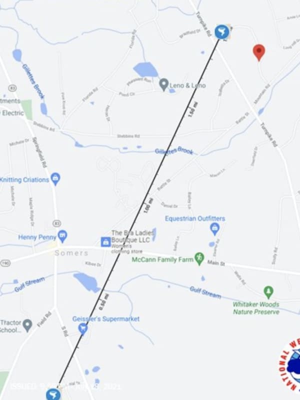
Tornado Confirmed In Northern CT, Bringing Down Trees, Destroying Vehicles
A tornado touched down in Connecticut during a severe thunderstorm leaving behind damaged trees, missing shingles, and two destroyed vehicles.
The tornado rated an EF-0 (the weakest of the five levels on the Enhanced Fujita Scale), touched between 6:11 p.m. and 6:18 p.m., Sunday, July 18, in the Town of Somers, located in Tolland County near the Massachusetts border, according to the National Weather Service.
The tornado was first reported by amateur radio operators on a tip from a trained Skywarn Weather Spotter, the service said.
The tornado, which traveled for about 1.9 miles, first tou…
Severe Thunderstorm Watch In Effect For Most Of Region
A Severe Thunderstorm Watch is now in effect for much of the region.
It lasts until 10 p.m. Wednesday, June 30, and covers Westchester, Rockland, Putnam, Dutchess, Orange, Ulster, Sullivan, Greene, Columbia counties in New York, Fairfield, Hartford, Litchfield, New Haven, Tolland, New London, and Middlesex counties in Connecticut, and all of Massachusetts except Cape Cod, and northeast Pennsylvania. (See image above.)
Torrential rainfall is likely during storm activity. Quarter-sized hail, damaging winds, and frequent lightning are possible, along with power outages, the National …
Line Of Thunderstorms, Some Severe, Sweeping Through Region, With Gusty Winds, Hail Possible
A line of thunderstorms, some severe, is sweeping through the region from the west to the east on Tuesday afternoon, June 8.
Storm activity is expected to continue through the afternoon and evening.
Wind gusts up to 60 miles per hour and penny-sized hail are possible.
"There is the potential for heavy rainfall which may produce localized flash flooding," the National Weather Service said in a Hazardous Weather Statement on Tuesday. "Gusty winds and lightning strikes are also threats."
Wednesday, June 9 will be another hot, humid, and potentially stormy day, with partly sunn…
Severe Thunderstorm Watch Now In Effect With Damaging Wind Gusts, Tornadoes Possible
A Severe Thunderstorm Watch has now been issued for much of the region.
It lasts until 11 p.m. Wednesday, May 26 in Hampden, Hampshire, Franklin, Worcester, Middlesex,c and Essex counties in Massachusetts, until 8 p.m. in the Berkshires, and until 11 p.m. in Hartford, Tolland, and Windham counties in Connecticut, and until 10 p.m. in Litchfield and Fairfield counties.
"An approaching cold front will bring potential for scattered strong to severe thunderstorms this afternoon into this evening," the National Weather Service said in a statement accompanying the alert. "Strong to dama…
Strong To Severe Storms Will Bring Damaging Wind Gusts, Possible Tornadoes, Hail
A line of thunderstorms will sweep through the region, bringing the potential for severe weather.
The time frame for the storm system, which will be ignited by an approaching cold front, is late Wednesday afternoon, May 26 through Wednesday evening.
Damaging wind gusts, large hail, and a couple of tornadoes are possible, the National Weather Service said in a Hazardous Weather Outlook statement issued Wednesday.
"Strong to damaging wind gusts will be the main threat," the statement said.
The high temperature will shoot back up to the upper 80s to around the 90-deg…
Tropical Storm Expected To Become Hurricane Could Bring Downpours To Region
Tropical Storm Zeta, expected to strengthen to hurricane status within hours, may bring significant rainfall to the region later this week.
Zeta is located was located over the northwestern Caribbean Sea about 130 miles southeast of Cozumel, Mexico, at midday on Monday, Oct. 26.
Zeta is moving toward the northwest near 10 miles per hour, the National Hurricane Center said.
On the forecast track, the center of Zeta will move near or over the northern Yucatan Peninsula later Monday afternoon or Monday night, move over the southern Gulf of Mexico on Tuesday, Oct. 27, and appr…
Rounds Of Storms, Some Severe With Damaging Winds, Will Lead To Big Change In Weather Pattern
Separate rounds of scattered, potentially severe thunderstorms will bring about a big change in the weather pattern.
Hazy, hot and humid weather will continue in the beginning of the week with a chance of afternoon and early evening showers and thunderstorms,, before widespread, stronger storms sweep through covering the entire region, according to the National Weather Service.
Monday, Aug. 24 will be partly sunny and warm with a high temperature around 90 degrees.
There will be a chance of scattered showers and storms, mainly after 3 p.m. The storm chance will last until a…