Find Your Daily Voice
Hampden
Your Local News for Hampden County, Massachusetts
Saturday, apr 27
45°
Follow
News
Schools
Business
Obituaries
Police & Fire
Weather
Lifestyle
Politics
Sports
Real Estate
Tags
Jobs
Shop
Support Us
Hampden
Follow
Find Your Daily Voice
News
Schools
Business
Obituaries
Police & Fire
Weather
Lifestyle
Politics
Sports
Real Estate
Tags
Jobs
Shop
Support Us
Home
About us
All sites
Advertise with us
Contact us
Terms of use
Privacy policy
Code of ethics
Site Map
© 2024 Cantata Media
45°
Saturday, apr 27
Tag:
Power Outages
Weather
Lower Updated Snow Totals For Mass; Gov. Healey Says Residents Should Prepare Emergency Kits
The National Weather Service said the winter storm expected to batter much of the Northeast on Tuesday, Feb. 13, has taken a "southward shift," which could mean less snow for Massachusetts. Gov. Maura Healey has asked residents to prepare and take precautions anyway. According to the latest prediction models, the northwestern portion of the state is now expected to receive to up 3 inches of snow, with a band running from the west through Springfield and up to Lawrence getting as much as 6 inches, according to forecasters. Worcester and Boston could receive 6 to 8 inches. …
News
New Storm Approaches MA: Eversource Preparing For More Power Outages, Damage
Ahead of an upcoming storm system that has the potential to bring gusty winds and downpours to Connecticut and Massachusetts, Eversource is detailing how it is preparing to respond to more power outages brought about by the weather. In a statement on Thursday evening, Jan. 11, Eversource representatives said they are currently making preparations for a storm system predicted to arrive on Friday night, Jan. 12, and continue into Saturday, Jan. 13. Related Report - Here's When To Expect Heaviest Rain, Strongest Winds From New Storm, Upcoming Snow Chances The storm may bring …
Weather
Weekend Nor'easter Will Be First Of 2 Coast-To-Coast Storms In Span Of Days: Here's Latest
The new year is starting with a bang weather-wise as back-to-back coast-to-coast storms are due to move through the Northeast in the span of a few days. Click here for a new, updated story - Projected Snowfall Totals Increase As Nor'easter Nears: These Spots Could See 18 Inches The time frame for the first system, a massive Nor'easter, is from late in the day Saturday, Jan. 6 into Sunday, Jan. 7, according to the National Weather Service. It has the potential to drop a foot or more of snow in areas farthest inland and a widespread 3 to 6 inches in most areas farther off the coast. The…
News
Devastating East Coast Storm Leaves 5 Dead, Including Massachusetts Man, 2 Missing
Five people were killed and two others went missing during the powerful storm with torrential rain and damaging winds pummeled the Northeast. In upstate New York, 76-year-old MaryAnn Hyland died when her Chevrolet SUV became submerged in floodwaters in the village of Catskill in Greene County late Monday morning, Dec. 18, according to this Daily Voice report. Hyland was a resident of the hamlet of Leeds in Greene County. In Hanover, Massachusetts, about 25 miles south of Boston, 89-year-old Robert Horky was killed after a tree fell on a small travel trailer he was in at around 9:45 a.m…
Police & Fire
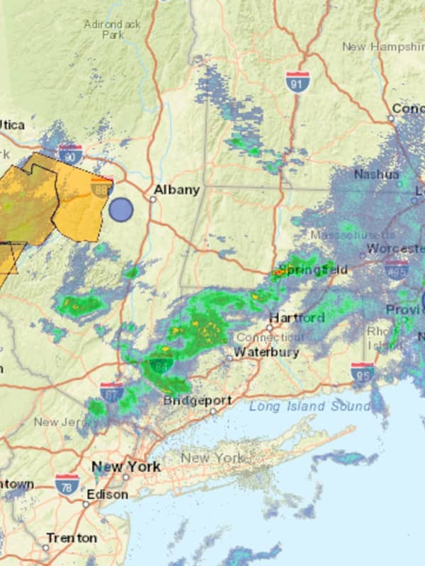
Flooding, Power Outages Plague Mass After Storms Pummel Northeast
Heavy downpours led to widespread flooding and power outages across eastern Massachusetts on Monday, Dec. 18, and it could be days before authorities can restore electricity to all homes. More than 270,000 people were left without power as of Monday afternoon, the Massachusetts Emergency Management Agency (MEMA) said. Bad weather also led to more than 200 flight cancellations at Boston Logan Airport, according to FlightAware, with more than a third of flights coming to or leaving from the airport delayed. Cities in Plymouth and Bristol counties felt the brunt of the storm, with over 9…
News
Hurricane Lee: Eversource Bringing In Extra Crews To Region As Storm Comes Closer
With the threat of Hurricane Lee drawing near, Eversource is preparing for power outages by enacting emergency response plans and bringing extra crews to the region to help with repairs. The preparations come as meteorologists predict Lee's arrival in the region on Friday night, Sept. 15, which will likely bring high wind gusts and heavy rainfall, according to the National Weather Service. Earlier Report - Here Comes Hurricane Lee: Watches, Advisories Stretch From NY Through New England Eversource President of Electric Operations in Connecticut Steve Sullivan warned that the sto…
Weather
New Severe Weather Threat: Here's Timing For More Storms With Flooding Downpours, Strong Winds
More potentially severe scattered thunderstorms are once again expected to sweep through the region for the second half of the weekend after previous activity resulted in downed trees and thousands of power outages the previous three days. The next window for storm activity is in the afternoon and evening on Sunday, Sept. 10. "Slow-moving showers and thunderstorms along a stalled frontal boundary could produce locally heavy downpours this afternoon and evening," the National Weather Service said in a Hazardous Weather Statement issued early Sunday morning. The mai…
News
Palmer Man Killed By Falling Tree While Camping With Fiancée In Vermont ID'd
A 33-year-old Hampden County man on a camping trip in Vermont was killed on Friday, Sept. 8, when a tree fell on him during a storm, authorities said. Joshua Przybycien, of Palmer, was camping with his fiancée, Kathryn Workman, in Somerset, Vermont, when high winds and heavy rains toppled the tree around 1 a.m., Vermont State Police said. No one else was injured. Related: Community Rallies Around Palmer Man Killed By Falling Tree Adam Przybycien posted on Facebook that Joshua was "kind and loved by all." Long Live Joshua Przybycien. I Love you man it still don’t feel real and it …
Weather
New Rounds Of Storms With Strong Winds, Drenching Downpours Could Cause More Power Outages
More potentially severe scattered thunderstorms are expected to sweep through the region this weekend after previous activity resulted in downed trees and thousands of power outages the previous two days. The next window for storm activity is in the afternoon and evening on Saturday, Sept. 9. The main threat will be damaging winds, with additional threats for isolated large hail and flash flooding triggered by drenching downpours, according to the National Weather Service. Humid conditions will linger Saturday, but it won't be as hot as it has been the last several days, with a …
Weather
Storm Watch: System With Damaging Winds Could Include Hail, Isolated Tornadoes
The month of April will get off to a stormy start with steady rainfall at times followed by severe thunderstorms with damaging winds that could cause power outages. The system arrived in the pre-dawn hours on Saturday, April 1 with rain and showers. Storm activity is expected to pick up in the afternoon through the evening. For a look at the wide area where severe storms are possible, see the first image above from AccuWeather.com. "The primary threat is from damaging wind gusts, but hail and an isolated, brief tornado are also possible," the National Weather Service said in…
Weather
(
Updated
) School Closings: Springfield, Holyoke, Chicopee Plan Early Dismissals For Storm
The National Weather Service has issued a hazardous weather outlook for Central and Western Massachusetts on Monday, March 15, through Wednesday as a nor'easter will blanket the area with heavy snows and high winds. Several schools have announced they will be closed on Tuesday. The Berkshires Adams-Cheshire Regional School District Berkshire Hills Regional School District Central Berkshire Regional School District Farmington River Regional School District Gabriel Abbott Memorial School Hancock Regional School District Lee Public Schools Mount Greylock Regional School District North Ad…
Weather
Nor'easter: These Parts Of Region Could See 18 Inches Of Snowfall From Multi-Threat Storm
Updated story - Storm Watch: These Areas Expected To See Extreme, Major Impacts From Nor'easter Parts of the region could see as much as 18 inches of snowfall from a multi-threat Nor'easter. The time frame for the storm is Monday night, March 13 into late Tuesday evening, March 14, according to the National Weather Service. Everyone throughout the region will be affected -- with heavy snowfall the biggest threat inland, and flooding and strong winds that could cause power outages the biggest threats around the coast. For snowfall projections for the entire Northeast, see t…
Weather
Strong Winds From Powerful Nor'easter Could Cause Power Outages: Here's Latest
Updated story - Storm Watch: These Areas Expected To See Extreme, Major Impacts From Nor'easter A potent Nor'easter that could dump as much as 18 inches of snow in some inland areas will be packed with strong winds that could cause power outages. The time frame for the storm is Monday night, March 13 into late Tuesday evening, March 14, according to the National Weather Service. Wind gusts will range from 40 to 70 miles per hour starting Monday night, March 13. (See the first image above from AccuWeather.com.) Areas most at risk for power outages due to fallen trees and power lines a…
Weather
Potent Storm System Brings Mix Of Heavy Rain, Snow, Strong Winds To Northeast
A strong storm system packed with a mix of snow, sleet, and rain is moving from west to east through the region on Saturday morning, March 4. Areas south of the Interstate 84 corridor have seen mainly rain, with flooding in some spots, especially along the coast, where a widespread 1 inch of rainfall has fallen, according to the National Weather Service. Wind gusts as strong as 66 miles per hour were reported in coastal Connecticut (in Greenwich at 4 a.m. Saturday) and 62 mph on Long Island (in East Hampton just before 5:30 a.m. Saturday). Heavy snow continues to fall across the north…
Schools
School Closings: List Grows As Subzero Temperatures Approach Massachusetts
As dangerous wind chills and subzero temperatures are expected to move through the state, many Massachusetts school districts are closing for the day on Friday, Feb. 3. The National Weather Service predicts the lowest wind chills could be between -15 and -45 degrees Fahrenheit from Friday night into Saturday morning. Isolated power outages and snow squalls are expected and the risk for frostbite will also be high. Dangerous Wind Chills Fri-Sat across southern New England. Isolated power outages possible due to strong winds. A few isolated snow squalls possible late tonight into early …
Weather
Here's When Damaging Wind Gusts From Multi-Hazard Winter Storm Could Cause Power Outages
Damaging wind gusts triggered by a multi-hazard winter storm bringing rain, sleet, and snow could cause power outages in much of the Northeast. Precipitation from the storm, which is moving from west to east on Wednesday morning, Jan. 25, is expected to wind down shortly after daybreak on Thursday, Jan. 26, but strong wind gusts are expected to continue throughout the day, according to the National Weather Service. Generally, gusts will be around 30 miles per hour, but areas near the coast could see 40 mph gusts on Thursday. Wind speeds will increase Wednesday night with gusts of 30 m…
Weather
Thousands Without Power As Wintry Storm System Moves Through Massachusetts
Thousands of Massachusetts residents were in the dark as a wintry storm system dumping both rain and snow moved through the area on Monday, Jan. 23. A Winter Weather Advisory was in place for about half of the state while a Winter Storm Warning was in place for the other half until 5 p.m, the National Weather Service reports. Snowfall totals, some up to five inches, were expected to be higher in the western parts of the state where a majority of power outages were reported as well. Here are the latest snowfall amounts for the current storm through 11 am. The bulk of the snowfall so f…
Weather
Rapid Freeze To Follow New Round Of Rain, Gusty Winds As Cold Front Arrives
A new round of rain and wind from a massive storm system will accompany a cold front that will push through the region Friday afternoon, Dec. 23, leading to a dramatic drop in temperatures, according to the National Weather Service. With blizzard-like conditions in much of the Midwest, more than 1,000 flights have been canceled as of early Thursday morning. Nationally, over there have been over a million power outages. As the storm system moves off the coast, temperatures "will plummet from Friday afternoon to Friday night," according to AccuWeather.com, which noted that, "in some cases, a …
Weather
Eye Of The Storm: System With Damaging Winds Causing Power Outages, Flooding, School Closures
A massive pre-Christmas storm packed with damaging wind gusts and heavy downpours is causing localized flash flooding, power outages, and some school closures in the region. The system, which arrived Thursday afternoon, Dec. 22, will wind down by Friday evening, Dec. 23. A total of between 2 to 3 inches or more of rainfall is possible. For a look at the precipitation types from the system, with rain in green and a mix of rain and snow in pink, click on the first image above from AccuWeather.com. "Gusty winds could blow around unsecured objects," the National Weather Service said in a…
Weather
Thousands Without Power As Snow Blankets Parts Of Western Mass
As much as a foot of snow has fallen in parts of Western Massachusetts on Friday, Dec. 16, with more on the way. But along with the beautiful views come traffic issues and power outages. The Massachusetts Emergency Management Agency (MEMA) lists more than 3,000 power outages in pockets across the state, with most reported in the west, where snow is at its heaviest. With more snow forecast to fall throughout the day and into Saturday, those numbers could increase. Click here to see an updated map of power outages across Massachusetts. Here's a look at snowfall reports through ~11:30 …
Weather
More To Come: New Storm System On Track For Region Will Bring Round Of Rain, Gusty Winds
A cold front that accompanied a potent storm system that caused power outages throughout the region has ushered in cold temperatures and will be followed by another round of gusty storms. A breezy and chilly day is in store to start the first day of December as strong high pressure begins to build in from the west, according to the National Weather Service. Wind-chill value temperatures will be 10 to 20 degrees colder on Thursday afternoon, Dec. 1 than they were 24 hours earlier. (See the first image above from AccuWeather.com.) Though the high temperature Thursday will be around 40 d…
Weather
Potentially Historic Storm: Parts Of NY Could See Up To 6 Feet Of Snow From 'Intense' System
A potentially historic, extreme storm that will bring intense snowfall and accumulation of 3 to 6 feet to parts of New York over a period of days has prompted Gov. Kathy Hochul to issue a State of Emergency for 11 counties in the state. The most significant snowfall is expected Thursday, Nov. 17, and Friday, Nov. 18, with accumulations of up to 3 feet of snow possible in the Buffalo area and up to 2 feet of snow possible in the Watertown area, with snowfall rates of 3 inches per hour, according to the National Weather Service. Thundersnow is possible in the most intense bands, according to…
Weather
Potentially Severe Storms Could Bring 60 MPH Winds, Heavy Downpours, Isolated Tornadoes
Scattered showers and potentially potent thunderstorms are expected ahead of an approaching cold front Sunday, Sept. 25 into the overnight hours of Monday morning, Sept. 26,. A few of the storms could become strong to severe, according to the National Weather Service, which noted that the primary threat from the system will be damaging winds. Gusts could be as high as 55 to 60 miles per hour and could damage trees and power lines and result in localized power outages. Localized 1-inch hail could result in damage to motor vehicles, the weather service said. There's also a risk for an …
Weather
Severe Thunderstorm Watch Issued As Strong System With Damaging Winds Targets Region
A Severe Thunderstorm Watch has just been issued for the region. It's in effect until 8 p.m. Monday, May 16. Scattered storms moving from west to east may produce damaging winds, hail, a few tornadoes, and isolated flash flooding, the National Weather Service said. Wind gusts of 60 miles per hour are expected in some spots where the storms are most severe. Most of the storm activity is now expected to come between 4 p.m. and 8 p.m. (See the two images above with forecast models from the National Weather Service.) "The main threat will be locally strong to damaging wind gusts al…
Weather
Heavy Rain Causes Flooding In Parts Of Region; Here's Long-Range Outlook As Storm Moves Out
A potent Nor'easter that swept through the region overnight is now pushing off the coast, with its heavy rains causing flooding on roadways and low-lying areas in parts of the area and its gusty winds leading to power outages. Conditions will remain blustery on Tuesday, April 19, with winds out of the Northeast at speeds of around 15 miles per hour with gusts as high as 30 mph at times, according to the National Weather Service. It will be cloudy throughout the day with a high temperature in the low to mid 50s. After rain and showers from the storm taper off around mid-morning, there …
Weather
Here's Timing For Massive Nor'easter Bringing Damaging Winds That Could Knock Out Power
A quick-moving, multi-faceted Nor'easter will bring heavy rain, possible flooding, damaging winds that could knock out power, with some areas farther north seeing significant snowfall. The current projected time frame for the storm is from early Monday evening, April 18 until around 8 a.m. Tuesday, April 19. Rainfall totals from the system will be between 1 and 2 inches. Wind gusts during the height of the storm will be upwards of 30 miles per hour, and as high as 50 mph in some spots. "Gusty winds could blow around unsecured objects," the National Weather Service said in a Haz…
Weather
Here's Timing For Severe Storm System With Damaging Wind Gusts, Heavy Downpours, Possible Hail
A massive storm system will bring damaging wind gusts, heavy downpours, and possible hail to the region. The system will arrive in this region in the early to mid afternoon Thursday, April 14, with scattered storm activity lasting at times until the late evening, according to the National Weather Service. In addition to torrential downpours and hail, there will be strong wind gusts, says AccuWeather.com, which added that "the storms can grow strong enough to break tree limbs and cause localized power outages. "Downpours can be intense enough to lead to brief street and hig…
Weather
Line Of Strong Storms With Damaging Winds Sweeping Through Region: Here's Latest
A line of severe thunderstorms with damaging wind gusts that could cause power outages is moving from west to east as a strong cold front sweeps through the region. A Wind Advisory that went into effect Monday, March 7 at 6 p.m. lasts through 4 a.m. Tuesday, March 8, the National Weather Service announced. Gusts of up to 50 miles per hour are possible during that time. "Gusty winds could blow around unsecured objects," the weather service said. "Tree limbs could be blown down and a few power outages may result." Earlier report - Weather Whiplash: Storms With Strong Wind Gusts …
Weather
Wind Advisory: 50 MPH Gusts During Round Of Storms Could Cause Power Outages
A strong cold front will be ushered in by a round of heavy thunderstorms with damaging wind gusts that could cause power outages. A Wind Advisory has been issued for the region from 6 p.m. Monday, March 7 until 4 a.m. Tuesday, March 8, the National Weather Service announced. Gusts of up to 50 miles per hour are possible during that time. "Gusty winds could blow around unsecured objects," the weather service said. "Tree limbs could be blown down and a few power outages may result." Earlier report - Weather Whiplash: Storms With Strong Wind Gusts Will Be Followed By New Chance…
Weather
Here's Latest Timing On Powerful Storm With Strong Winds That Could Cause Power Outages
A powerful, multiple-hazard storm will sweep through the Northeast, with the main impact on this region being strong, gusty winds that could cause power outages. The storm will arrive in this region on Thursday night, Feb. 17 and continue into early Friday morning, Feb. 18. “The highest winds gusts will arrive in areas from the Delmarva (Peninsula) to New York City early Thursday night before spreading into coastal southern New England later at night and into the early hours of Friday morning,” AccuWeather Senior Meteorologist Dean DeVore said. A Wind Advisory is in effect from late Thursd…
Weather
These Areas Are Most At Risk For Damaging Wind Gusts From Storm Heading To Region
Damaging wind gusts will be the main threat from a new winter storm that will sweep through the region. The strong cross-county storm moving from the west to the Northeast will arrive in this region on Thursday, Feb. 17 and continue into early Friday morning, Feb. 18. The most powerful wind gusts, which could be in excess of 60 miles per hour, will be mainly on Long Island and southeastern Connecticut, the National Weather Service said in a Hazardous Weather Outlook statement issued Tuesday morning, Feb. 15. "Confidence is increasing in the potential of wind gusts of 45 to 55 mph …
1
2
3
4
Archive