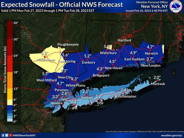
The National Weather Service says areas farther inland will see the most snowfall from the system.
While most places will see snow at the onset of the storm later in the day on Monday, Feb. 27, coastal areas are likely to get a mix with and changeover to plain rain overnight into Tuesday morning, Feb. 28, the National Weather Service said.
For the latest projected snowfall totals, see the image above.
"Snowfall amounts for the NYC/NJ metro area and Long Island are the most uncertain," the weather service said in a statement early Sunday afternoon, Feb. 26. "It will be dependent on the intensity of snowfall at the onset, how quickly warm air comes in aloft from the southwest, and wind direction at the surface.
"Southern portions of LI and NYC may see little snow with the quickest warming, while the northernmost areas could see a quick 1 to 3 inches before the changeover."
The weather service says it will update its projections on Monday as it examines new models.
Areas to the north of I-287 in the Hudson Valley and I-95 in southern Connecticut should be mainly snow/sleet, the weather service says.
In interior portions of New York and Connecticut, 4 to 6 inches of snowfall is possible, resulting in hazardous travel and snow-covered roads for the Monday evening and Tuesday morning commutes in those areas.
Wet, heavy snow could fall at rates of 1 inch an hour from 7 p.m. Monday to 1 a.m. Tuesday in those areas.
So far, one county in the region is under a Winter Storm Watch: Orange County in the Hudson Valley. It's in effect from 3 p.m. Monday to 1 p.m. Tuesday.
This continues to be a developing story. Check back to Daily Voice for updates.
Click here to follow Daily Voice White Plains and receive free news updates.
