The time frame for the storm is Monday, Feb. 12 into Tuesday, Feb. 13.
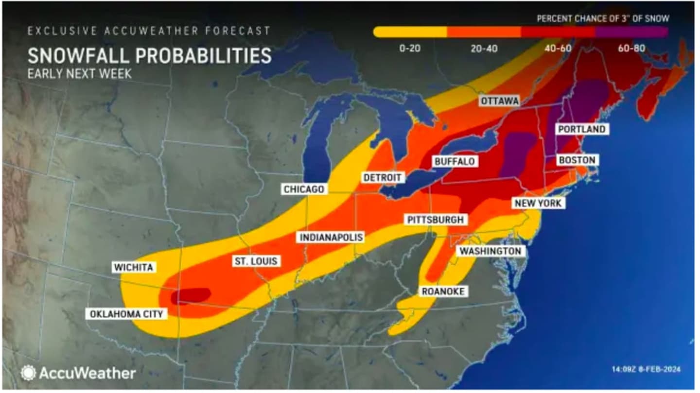
In the image above from AccuWeather.com, areas in the darkest shades have the highest probability of seeing snowfall, with a 60 to 80 percent chance in those spots marked in purple, 40 to 60 percent chance in areas in red, 20 to 40 percent chance in parts of the region marked in orange and a less than 20 percent chance for those areas in yellow.
Uncertainty surrounds the track and strength of the system, so it's too early to predict snowfall amounts.
A weak warm front will move through on Friday, Feb. 9, according to the National Weather Service, which notes that "any early morning cloud cover should dissipate by midday, with a sunny late morning and afternoon expected. This should lead to another mild day, with high temperatures 10 to 15 degrees above normal."
Friday's high temperature will be right around 50 degrees.
Unseasonably mild temperatures will continue Saturday, Feb. 10 with the possibility of maximum temps close to 20 degrees above normal, with a high temperature generally in the mid-50s with some areas farthest south possibly even hitting the 60-degree mark.
Sunday, Feb. 11's high will be around 50 degrees with a mix of sun and clouds before a cooling trend starts overnight as clouds thicken into Monday, setting the stage for the potential new storm system.
It will be mostly cloudy on Monday with a high temperature in the 40s. Precipitation will become possible starting in the morning and then again at night.
With the low temperature expected to drop to just below the freezing mark overnight into Tuesday, a widespread mix of rain, sleet, and snow is expected from the system.
"There is going to be a change in the pattern with a potentially impactful storm coming swinging across the Midwest and Northeastern states from Monday to Tuesday," AccuWeather Meteorologist Dean DeVore said.
After the quick-moving system moves through, temperatures will become more seasonable with highs in the 30s expected each day through the end of next week.
The current outlook for Valentine's Day on Wednesday, Feb. 14 calls for mostly sunny skies and a high temperature in the mid-30s.
Check back to Daily Voice for updates.
Click here to follow Daily Voice Suffolk and receive free news updates.