Tag:

Winter Weather

'Get Your Snow Shovels Ready': AccuWeather Releases Winter Outlook 'Get Your Snow Shovels Ready': AccuWeather Releases Winter Outlook
'Get Your Snow Shovels Ready': AccuWeather Releases Winter Outlook Forecasters for AccuWeather have released their projections for the winter of 2023-24. Senior Meteorologist Paul Pastelok and his team are saying it's shaping up to be much different than last winter, especially across the central and eastern United States, and one month may leave the biggest impression. "February can be an active and intense month," Pastelok said. One of the driving forces this winter will be the strengthening El Niño, which will play a significant role in the weather across the United States throughout the entire winter season.  Earlier report - 'Super'…
'Get Ready For A Winter Wonderland': Old Farmer's Almanac Releases 2023-24 Forecast 'Get Ready For A Winter Wonderland': Old Farmer's Almanac Releases 2023-24 Forecast
'Get Ready For A Winter Wonderland': Old Farmer's Almanac Releases 2023-24 Forecast 
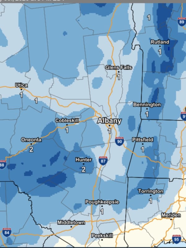
The mild winter of 2022-23 may become a distant memory with more typical conditions expected in 2023-24, according to the Old Farmer's Almanac. "The 2024 Old Farmer’s Almanac predicts snow, seasonable cold, and all of winter’s delights," states the publication, which has been making long-term weather forecasts since 1792. "This winter’s forecast is sure to excite snow bunnies and sweater lovers alike, promising a whole lot of cold and snow across North America." In the Northeast,  snow will arrive beginning in November, with storms, showers, and flurries continuing through the sta…
Nor'easter: Dozens Of Flights Canceled At Albany International Airport Due To Snow Nor'easter: Dozens Of Flights Canceled At Albany International Airport Due To Snow
Nor'easter: Dozens Of Flights Canceled At Albany International Airport Due To Snow A powerful Nor’easter that brought heavy snow to much of the region also brought plenty of flight delays. At Albany International Airport, 27 flight departures had been canceled due to winter weather as of 2 p.m. Tuesday, March 14, airport spokesperson Doug Myers told Daily Voice. Related Report: Nor'easter: Potent Storm With Gusty Winds Brings Mix Of Snow, Rain, Causes School Closures Airlines are warning that additional cancellations or delays are possible. Passengers were advised to check the status of their flight online. Nearly 7 inches of snow had fallen at the airport by Tues…
Nor'easter: State Of Emergency Declared In Dutchess County Nor'easter: State Of Emergency Declared In Dutchess County
Nor'easter: State Of Emergency Declared In Dutchess County New story - Nor'easter: Potent Storm With Gusty Winds Brings Mix Of Snow, Rain, Causes School Closures New York Gov. Kathy Hochul has declared a state of emergency ahead of a late winter Nor'easter that’s expected to bring heavy, wet snow and other challenging conditions to the region. Hochul urged New Yorkers to prepare for a multi-day event that could bring more than a foot of snow to portions of the Hudson Valley and Capital Region, according to the National Weather Service. Earlier Report: Storm Watch: These Areas Expected To See Extreme, Major Impacts From Nor'easter "State agencie…
Significant Storm Possible At Week's End: Separate Rounds Of Precipitation Will Come First Significant Storm Possible At Week's End: Separate Rounds Of Precipitation Will Come First
Significant Storm Possible At Week's End: Separate Rounds Of Precipitation Will Come First Separate rounds of precipitation will precede a potentially more significant storm on track for the region at the end of the week. Tuesday, Feb. 7 will be clear and brisk during the day before the arrival of a frontal system that will moderate temperatures. The system will move across the region late in the afternoon and in the evening, bringing mixed precipitation, with mainly showers and light snow and areas of sleet or freezing rain that could result in localized slippery travel farthest north and inland.  After the front passes, the high temperature on Wednesda…
Don't Write Off Winter Yet: Here's Long-Range Outlook As Groundhog Day Nears Don't Write Off Winter Yet: Here's Long-Range Outlook As Groundhog Day Nears
Don't Write Off Winter Yet: Here's Long-Range Outlook As Groundhog Day Nears Punxsutawney Phil may be getting warmed up -- literally -- to make his annual Groundhog Day prognostication from his perch in Pennsylvania.  However, no matter what he says, it will still feel like winter for most of the Northeast over the next six weeks, according to a brand-new long-range forecast. According to AccuWeather.com, most of the Northeast is in the "Winter Leaves, Then Returns Category" in the outlook for the next six weeks. (See the image above.) Nevertheless, as we approach Groundhog Day, on Thursday, Feb. 2, the first of Phil's options appears to be off the table.…
Chance For New Round Of Rain Will Be Followed By Dip In Temps As Groundhog Day Nears Chance For New Round Of Rain Will Be Followed By Dip In Temps As Groundhog Day Nears
Chance For New Round Of Rain Will Be Followed By Dip In Temps As Groundhog Day Nears Punxsutawney Phil has one job. And through the years, he's done it pretty well. For the last three-quarters of a century, from his perch in Pennsylvania, the beloved groundhog has correctly predicted whether there will be an early spring 69 percent of the time, according to an Axios analysis of NOAA data. But this year, the beloved critter's job might be a bit more complicated. After all, according to legend, there will be six more weeks of winter if he sees his shadow. If he does not, then spring will come early. But as we approach Groundhog Day, on Thursday, Feb. 2, the first of Phil's …
Here's Next Window For Snowfall As Alberta Clippers Sweep Through Northeast Here's Next Window For Snowfall As Alberta Clippers Sweep Through Northeast
Here's Next Window For Snowfall As Alberta Clippers Sweep Through Northeast There are no major winter storms currently on track in the coming days for the region, but quick-hitting snowstorms known as Alberta clippers are forecast for parts of the Northeast, according to AccuWeather.com. Most of the Clipper activity this week will be in upstate New York and northern New England, but there will be a window in which some snow is possible in this region later in the week. Tuesday, Feb. 8 will be partly cloudy with a high temperature in the low 40s, according to the National Weather Service. There will be sunny skies on Wednesday, Feb. 9 on a blustery day, with a high…
Arrival Of Icy Mix Of Freezing Rain, Sleet, Snow Causes Many School Closures Arrival Of Icy Mix Of Freezing Rain, Sleet, Snow Causes Many School Closures
Arrival Of Icy Mix Of Freezing Rain, Sleet, Snow Causes Many School Closures The arrival of a massive winter storm bringing a mix of snow, sleet and freezing rain has caused many school closures throughout the region on Friday, Feb. 4. As the morning has progressed, a wave of cold air has allowed the wintry mix and snow lines to shift southward. (See the radar image above.) That trend will continue as the temperature gradually continues to fall throughout the day. Winter weather advisories are in effect throughout the region until 7 p.m. Friday. While most of the region will see little or no snowfall accumulation, icy conditions will continue through the …
Icy Mix Will Be Followed By Deep Freeze As Arctic Air Mass, Coldest Temps Of Season Arrive Icy Mix Will Be Followed By Deep Freeze As Arctic Air Mass, Coldest Temps Of Season Arrive
Icy Mix Will Be Followed By Deep Freeze As Arctic Air Mass, Coldest Temps Of Season Arrive A new round of freezing rain accompanying a cold front will be followed by the arrival of an arctic air mass that will result in a plunge in temperatures. There have been reports of hazardous travel in areas that precipitation falls and temperatures remain below freezing on Sunday morning, Jan. 9, with a Winter Weather Advisory in effect until noon Sunday in areas north of New York City and Long Island, not including eastern Connecticut. "Slow down and use caution while traveling," the National Weather Service said in a Hazardous Weather Statement released Sunday morning.&nbs…
'It Has Begun': Video Captures First Snowflakes Of Season In New York 'It Has Begun': Video Captures First Snowflakes Of Season In New York
'It Has Begun': Video Captures First Snowflakes Of Season In New York Tis’ the season… New York State Police at a barracks upstate experienced the first snow of the season as the weather starts transitioning from fall toward winter. In the small town of Sidney in Delaware County, northeast of Binghamton, New York State Police from Troop C on Route 7 caught the first snowfall of the season on video as it began falling on squad cars. "It has begun," state police wrote in a social media post made around midday on Wednesday, Nov. 3. Earlier story - Some Parts Of Northeast Could See First Snowfall Of Season As Cold Air Arrives From Canada More winter weather is…
Winter 2021-22 Forecast Released By NOAA National Weather Service Winter 2021-22 Forecast Released By NOAA National Weather Service
Winter 2021-22 Forecast Released By NOAA National Weather Service The National Oceanic and Atmospheric Administration (NOAA) has just released its outlook for the winter of 2021-22.NOAA's National Weather Service forecasters are predicting cooler-than-average and wetter-than-average conditions in parts of the North with La Niña conditions once again predicted to shape part of the overall weather patterns this winter. For precipitation predictions for the upcoming season, see the first image above. Click here to see the complete NOAA winter outlook report. For a video look at NOAA's winter outlook, click here. Related story - Snow Joke: Get…
Winter Storm Watch Issued For Region: Here's Latest On What's Coming Winter Storm Watch Issued For Region: Here's Latest On What's Coming
Winter Storm Watch Issued For Region: Here's Latest On What's Coming After a one-day reprieve from the barrage of wintry weather on Wednesday, Feb. 17, a new storm taking aim on the region has the potential to dump a significant amount of snowfall. The time frame for the new storm is Thursday morning, Feb. 18 into Friday, morning Feb. 19, with the potential for moderate to heavy snowfall and a brief wintry mix, the National Weather Service said. A look at the coverage area for a Winter Storm Watch in effect from 6 a.m. Thursday until 6 a.m. Friday is shown in the first image above. The heaviest snow in the Northeast is expected from northern and c…
Arctic Blast, New Storm Could Be Coming After Stretch Of Dry Days, Meteorologists Say Arctic Blast, New Storm Could Be Coming After Stretch Of Dry Days, Meteorologists Say
Arctic Blast, New Storm Could Be Coming After Stretch Of Dry Days, Meteorologists Say A stretch of dry days with temperatures a bit above normal are expected at least through this weekend. But soon after that, we could see an Arctic blast that may lead to a big winter storm. "Enjoy the 'warmth' while it lasts, because Old Man Winter is looking to return with a vengeance," AccuWeather Senior Meteorologist Brett Anderson said. AccuWeather Senior and Lead Long-Range Meteorologist Paul Pastelok, meanwhile, noted that "Many of the chips are beginning to line up to suggest we will see a shift of the polar vortex and an Arctic invasion across the central and eastern US and Canada…
New Snowfall Projections Released For Storm That Will Sweep Through Region New Snowfall Projections Released For Storm That Will Sweep Through Region
New Snowfall Projections Released For Storm That Will Sweep Through Region New snowfall projections have been released for a storm system that will sweep through the region, bringing up to several inches of accumulation for areas inland from New York City and Long Island. A look at the latest projected snowfall totals from Sunday afternoon, Jan. 3 into early Monday morning, Jan. 4 is shown in the image above, released early Sunday morning by the National Weather Service. A Winter Weather Advisory for much of the area from 9 a.m. Sunday into midnight Monday for areas north of I-287 and the Merritt Parkway in New York, Connecticut, and Massachusetts. Motorists in th…
Winter Weather Outlook For Region Released By Farmers Almanacs Winter Weather Outlook For Region Released By Farmers Almanacs
Winter Weather Outlook For Region Released By Farmers Almanacs Want an early read on the weather outlook for the winter of 2020-21? There already are two forecasts by a pair of publications with long histories, and they're not exactly in agreement. "If you love the cold of winter, you’re going to love our forecast if you live in the northern half of the country," the Farmers' Almanac said. The Farmers’ Almanac says a major blizzard the second week of February will be among several big storms in our area. “This storm may bring up to 1-2 feet of snow to cities from Washington, D.C. to Boston,” the Farmers' Almanac writes. You can read the Farmers…
Here Are Latest Projected Snowfall Amounts For Rare Out-Of-Season Storm Here Are Latest Projected Snowfall Amounts For Rare Out-Of-Season Storm
Here Are Latest Projected Snowfall Amounts For Rare Out-Of-Season Storm Polar Vortex are words not associated with the month of May. But temperatures will be cold enough overnight that interior sections of the area will be seeing accumulating snowfall overnight as a rare out-of-season winter-like, spring storm will sweep through the Northeast. The time frame for snowfall, mainly north and inland, is overnight Friday, May 8 into Saturday morning, May 9.  Gusty winds that could cause scattered power outages will accompany the storm system. The strongest winds, however, will be on Saturday.  About 1 to 2 inches of snowfall accumulation is now poss…
Here's Next Chance For Wintry Mix As Unsettled Weather Pattern Arrives Here's Next Chance For Wintry Mix As Unsettled Weather Pattern Arrives
Here's Next Chance For Wintry Mix As Unsettled Weather Pattern Arrives A storm system has brought steady rain to the region, with areas far north and inland seeing sleet and some snow, leading to delayed school starts. The unsettled weather pattern will continue the next few days, with a new chance for a wintry mix that is expected to be more widespread. Monday, Feb. 10 will be cloudy with showers and pockets of heavy rain at times during the day and evening and a high temperature around 40 degrees. The overnight low will stay steady in the upper 30s for most of the region, but the areas north of I-84 that saw a wintry mix overnight Sunday, Feb. 9 into Monday…
Nor'easter Nears: Winter Weather Advisory Issued For Dutchess County Nor'easter Nears: Winter Weather Advisory Issued For Dutchess County
Nor'easter Nears: Winter Weather Advisory Issued For Dutchess County As a Nor'easter that will bring rain and wind to the entire area and sleet, freezing rain and ice farther inland approaches, a Winter Weather Advisory has been issued for much of the area. The weekend will end with another cold day on Sunday, Nov. 17. The high temperature will be in the upper 30s, but it will feel much colder, with the wind-chill factor between 15 and 25 degrees.  The Winter Weather Advisory has been issued for the counties shown in purple in the first image above, including Dutchess, Orange, Sullivan and Ulster in New York and Litchfield in Connecticut. In those area…
New Winter Weather Forecasts: 'Snow-verload' For Parts Of US, 'Wet, Wild' One In This Area New Winter Weather Forecasts: 'Snow-verload' For Parts Of US, 'Wet, Wild' One In This Area
New Winter Weather Forecasts: 'Snow-verload' For Parts Of US, 'Wet, Wild' One In This Area Parts of the United States will see a "snow-verload" during what will be a stormy winter for most of the nation, according to two brand-new long-range forecasts. The Old Farmer's Almanac predicts a "wet and wild" 2019-20 winter in the Northeast. The Farmers' Almanac says this region will see "a good amount of snow." Overall, the Old Farmer's Almanac is calling for "shivers, snowflakes ... and strong storms" with the "snow-verload" affecting mainly northern states in the west and midwest. "This winter will be remembered for strong storms bringing heavy rain and sleet, not to mention piles o…
Winter Weather Advisory: Projected Snowfall Totals For Overnight Storm Increase Winter Weather Advisory: Projected Snowfall Totals For Overnight Storm Increase
Winter Weather Advisory: Projected Snowfall Totals For Overnight Storm Increase By the time a new round of storms sweeps through the area through the weekend and ending on Monday, March 4, up to a foot of snowfall is possible. The latest storm Friday night, March 1 and continuing through around 9 a.m. Saturday, March 2 will bring 3 to 5 inches of accumulation. A Winter Weather Advisory is now in effect from 10 p.m. Friday until noon Saturday. Saturday's high temperature will climb to nearly 40 degrees with wind gusts up to 20 miles per hour and a wind-chill factor between 20 and 30. The second storm of the weekend is expected to arrive late in the afternoon on Sunday…
Eye On The Storm: Here's How Much Snowfall To Expect Eye On The Storm: Here's How Much Snowfall To Expect
Eye On The Storm: Here's How Much Snowfall To Expect A prolonged stretch of cold air will continue through week's end as March comes in like a lion. Those conditions will allow for two separate snow events, with the first on Wednesday, Feb. 27 into Thursday, Feb. 28. Clouds will increase Wednesday morning on a day in which the high temperature will be in the upper 20s with a wind-chill factor of between 10 and 20 degrees. Snow looks to arrive sometime between this late afternoon and early evening across the region.  The steadiest snow will occur Wednesday evening and should end by sunrise on Thursday. Most of the area will see abo…
Dangerous Cold: New Yorkers Urged To Take Caution Ahead Of Arctic Blast, Frigid Temps Dangerous Cold: New Yorkers Urged To Take Caution Ahead Of Arctic Blast, Frigid Temps
Dangerous Cold: New Yorkers Urged To Take Caution Ahead Of Arctic Blast, Frigid Temps With temperatures ready to plunge, New York officials are warning the region to be ready to brave the cold. Several weather systems moving through the state will bring ice-cold temperatures and frigid temperatures. The Arctic blast expected to strike has prompted New York Gov. Andrew Cuomo to take emergency measures. Cuomo said that he has “directed a Level 3 activation of the State Emergency Operations Center in order to prepare for and assist with any potential emergency response activities.” Area residents are also being warned that there will be an increased risk of travel during the w…
El Niño Will Have Significant Impact On Winter Weather, New Forecast Says El Niño Will Have Significant Impact On Winter Weather, New Forecast Says
El Niño Will Have Significant Impact On Winter Weather, New Forecast Says El Niño will be back and it will have a significant impact on the winter weather pattern in the area. El Niño is a large-scale ocean-atmosphere climate interaction linked to a periodic warming in sea surface temperatures across the central and east-central Equatorial Pacific. What does that mean for us? In a nutshell, we will see warmer than average temperatures through the end of the calendar year and near normal snowfall for the entire winter, according to a new outlook for the winter released by AccuWeather. (See first image above.) There is one caveat. Colder weather will arrive in J…
Snow Joke: New Storm Could Bring Up To 3 Inches Of Accumulation Snow Joke: New Storm Could Bring Up To 3 Inches Of Accumulation
Snow Joke: New Storm Could Bring Up To 3 Inches Of Accumulation This story has been updated. Let's start with the good news. Temperatures will actually become much more spring-like, starting in the middle of next week, with the last of the winter weather likely in the rearview mirror once and for all. Now here's the not-so-good news. Before that happens, the area is now likely to see more snowfall on back-to-back days, including a weekend storm that may bring up to 3 inches of accumulation. There is a chance of snow in the pre-dawn hours of Friday, followed by a chance of a wintry mix until late morning. Precipitation will turn to rain as the day's h…
Cuomo State Of Emergency Includes Parts Of Hudson Valley Cuomo State Of Emergency Includes Parts Of Hudson Valley
Cuomo State Of Emergency Includes Parts Of Hudson Valley This story has been updated with a video from a briefing held Wednesday afternoon in Rockland County. Hundreds of National Guard service members have been enlisted to assist areas impacted by the latest batch of winter weather as New York Gov. Andrew Cuomo declares a state of emergency in three Hudson Valley counties: Rockland, Putnam and Westchester. With between six and 18 inches of snow, and wind gusts upwards of 45 mph expected on Wednesday, Cuomo declared the state of emergency as the Hudson Valley braces for the fourth Nor’easter to hit in the past three weeks. In addition, Cuomo “di…
70,000 Now Without Power In Dutchess 70,000 Now Without Power In Dutchess
70,000 Now Without Power In Dutchess Update, 1:15 p.m. As of 1:15 p.m. on Friday, a Central Hudson Gas and Electric spokesperson announced that 70,000 outages have been reported, with more than 700 individual damage locations to be addressed.  "Outages and damage locations continue to be reported as the heavy snow and winds continue. Crews continue to work to restore service, and we will provide estimated restoration times as the severe weather subsides," John Maserjian of Central Hudson said. Earlier report: More than 10,000 Dutchess County residents find themselves losing power, as the latest Nor’easter batters t…
Numerous Crashes Occur Throughout Hudson Valley Tie Up Traffic Amid Storm Numerous Crashes Occur Throughout Hudson Valley Tie Up Traffic Amid Storm
Numerous Crashes Occur Throughout Hudson Valley Tie Up Traffic Amid Storm The winter weather conditions have led to multiple crashes on busy area roadways, leading to a hectic day on the roads for commuters. The New York State Department of Transportation and first responders had a busy Wednesday morning, battling the snow, while dealing with multiple accidents throughout the area, including an incident that shut down the new Tappan Zee Bridge for more than two hours before some lanes reopened. More than a dozen crashes were reported by the DOT as of noon on Wednesday afternoon, tying up the roadways for motorists. Multiple crashes have been reported on I-95, I-8…