Tag:

I-95 corridor

Split Storms Combine: Inch Per Hour Of Rain Could Fall In Nasty Weekend Storm, Forecasters Say Split Storms Combine: Inch Per Hour Of Rain Could Fall In Nasty Weekend Storm, Forecasters Say
Split Storms Combine: Inch Per Hour Of Rain Could Fall In Nasty Weekend Storm, Forecasters Say 
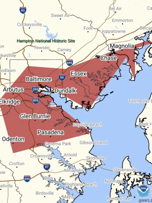
Much of the region is under a flood watch ahead of a heavy rain storm expected to arrive Friday night, March 22 and last through Saturday, March 23, the National Weather Service says. A flood watch east of the Blue Ridge is in effect from 2 a.m. to 2 p.m. Saturday, March 23, where up to an inch of rain per hour could fall, enhancing the threat of flooding, according to the NWS. The Flood Watch has been expanded to cover most locations east of the Blue Ridge. This is in effect on Sat 2 AM-2 PM... Posted by US National Weather Service Baltimore/Washington on Friday, March 22, 2024 "A…
Possibility Of Snow, Ice Storm For Northeast Next Week Hinges On One Factor: AccuWeather Possibility Of Snow, Ice Storm For Northeast Next Week Hinges On One Factor: AccuWeather
Possibility Of Snow, Ice Storm For Northeast Next Week Hinges On One Factor: AccuWeather A winter storm could hit the Northeast next week, but it depends on one factor, forecasters say. A dip in the jet stream. “Should a large dip develop in the jet stream, then a major winter storm will climb the Atlantic coast from Monday night to Tuesday night,” AccuWeather Senior Meteorologist Bob Smerbeck explained. “However, should only a shallow dip in the jet stream develop, the storm would be more likely to escape out to sea, off the southern Atlantic coast by midweek.” Weather maps show a dusting of between one and three inches, should the snow make its way up to New Jersey, eastern…
Tens Of Thousands In DMV Without Power With New Round Of Rain Approaching Tens Of Thousands In DMV Without Power With New Round Of Rain Approaching
Tens Of Thousands In DMV Without Power With New Round Of Rain Approaching Tens of thousands of residents throughout the DMV region are in the dark as whipping winds and heavy rains have knocked out power to some neighborhoods and businesses. With the worst of the storm yet to come, as of 7:30 p.m. on Tuesday, Jan. 9 Baltimore Gas and Electric crews were still working to repair 720 active outages impacting 34,513 of the company's 1,348,380. A breakdown, by county, at 7:30 p.m.:  Baltimore: 12,513 customers affected; Anne Arundel: 7,390; Howard: 6,532; Prince George's: 2,762 Baltimore City: 2,537; Harford: 1,511; Carroll: 1,101; Calvert: 111; Montgomery: 27.…
Flood Watches Issued As New Round Of Storms Set To Hit DMV Region Flood Watches Issued As New Round Of Storms Set To Hit DMV Region
Flood Watches Issued As New Round Of Storms Set To Hit DMV Region The DMV Region may be in for another round of rough weather on Tuesday afternoon. Forecasters say that there is a "Level 2" risk of severe weather on Tuesday, Aug. 15, which could bring isolated tornadoes, large hail, and potentially damaging winds, and flooding throughout the area.  The bulk of the bad weather is expected along the I-95 corridor and east, toward parts of Maryland, according to the National Weather Service. Most of the I-95 corridor has been upgraded to a Slight Risk for Severe Weather from the Storm Prediction Center for thunderstorms that are expected to move through…
Super Scorcher: Hottest Day Of The Year With Real-Feel Temps Climbing Near 110 Degrees Super Scorcher: Hottest Day Of The Year With Real-Feel Temps Climbing Near 110 Degrees
Super Scorcher: Hottest Day Of The Year With Real-Feel Temps Climbing Near 110 Degrees The hottest day of the summer has arrived. Friday, July 28 is expected to be a super scorcher, as temperatures are expected to be the highest they've been all summer, forecasters say. Temps are expected to peak above the 90-degree mark for the third day in a row in several major cities along the East Coast. Temps are expected to peak above the 90-degree mark for the third day in a row in several major cities along the East Coast.AccuWeather Good evening, severe weather threat has ended with the main story for Friday being the extreme heat! Posted by US National Weather Service Phil…
Severe Thunderstorm Warnings Issued For Parts Of DMV Region Amid Latest Bout Of Wild Weather Severe Thunderstorm Warnings Issued For Parts Of DMV Region Amid Latest Bout Of Wild Weather
Severe Thunderstorm Warnings Issued For Parts Of DMV Region Amid Latest Bout Of Wild Weather Some parts of the DMV region can expect extreme weather to continue as storms bringing hail and whipping winds continue to roll through the area. Some relief is on the horizon for residents in Maryland and Virginia, but not before Mother Nature goes one more round with winds reaching 60 mph and quarter-sized hail possible to fall in certain neighborhoods. Special Marine Warning including the Chesapeake Bay from Drum Point MD to Smith Point VA, Chesapeake Bay from North Beach to Drum Point MD, Chesapeake Bay from Sandy Point to North Beach MD and Choptank River to Cambridge MD and the Li…
Tornado, Hail Possible As Severe Weather Expected To Strike DMV Region Tornado, Hail Possible As Severe Weather Expected To Strike DMV Region
Tornado, Hail Possible As Severe Weather Expected To Strike DMV Region Severe thunderstorms bringing whipping winds and possibly hail to DC and Maryland are expected to rock the DMV region on Monday afternoon. A "severe weather outlook" has been issued for the entire region between 2 p.m. and 10 p.. on Monday, June 26 throughout the I-95 corridor, specifically during the evening commute, according to the National Weather Service. It will be an active weather day as severe thunderstorms are expected to impact areas east of the Alleghenies. These... Posted by US National Weather Service Baltimore/Washington on Monday, June 26, 2023 The storm is expected to …
First Projected Snowfall Totals Released For Midweek Storm Taking Aim On Region First Projected Snowfall Totals Released For Midweek Storm Taking Aim On Region
First Projected Snowfall Totals Released For Midweek Storm Taking Aim On Region Just as a complex system that brought a mix of rain and sleet, and as much as a foot of snow or more in some spots moves east, the first projected snowfall totals have been released for a second storm on track for the Northeast midweek. It's due to arrive Wednesday, Jan. 25, and could deliver more snow across interior areas, but also perhaps even closer to the I-95 corridor, unlike the first storm this week, according to AccuWeather.com. The currently projected timing for the system has it moving from west to east starting in the middle of the afternoon on Wednesday, according to the&n…
'Flash Freeze,' Wind Chill Warnings Issued For Parts Of Maryland On Winter Solstice 'Flash Freeze,' Wind Chill Warnings Issued For Parts Of Maryland On Winter Solstice
'Flash Freeze,' Wind Chill Warnings Issued For Parts Of Maryland On Winter Solstice Winter is here in more ways than one. Maryland is bracing for wicked weather in the coming days as a storm front is expected to dump rain, snow, and ice throughout the region that could hit parts of the state as soon as Wednesday night, marking the winter solstice and start of winter. A frosty first official day of winter. Teens & 20s this morning w/ highs expected to rebound into the upper 30s to mid 40s this afternoon. Precip. returns Thu. AM, w/ Winter Weather Advisories & Winter Storm Warnings well west of #Baltimore & #Washington. #VAwx #MDwx #DCwx #WVwx pic.twitter.com…