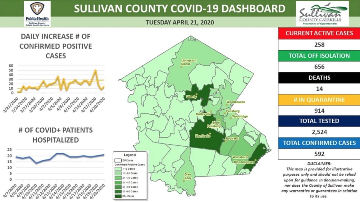

As of Wednesday, April 22, there have been 1,049 confirmed COVID-19 cases in Ulster, which have resulted in 19 deaths, while there have been 592 confirmed cases in Sullivan, which have led to 14 deaths since the outbreak began.
Sullivan County officials launched the map this week, which highlights the active cases throughout the county.
“This map generally displays where Sullivan County residents who have tested positive for COVID-19 live,” county officials noted. “It does not provide information on where the virus was actually transmitted, and you should assume that you can contract the virus anywhere. The map is based on the total number of positive tests results recorded since the start of the pandemic.”
Rather than providing exact numbers, Sullivan County is providing a range for each town “to protect privacy for the low number of residents who have tested positive in many of the county’s zip code,” officials said.
Cases in Sullivan County:
- Barryville: <10
- Bethel: <10
- Bloomingburg: 60+
- Burlingham: <10
- Callicoon: <10
- Callicoon Center: <10
- Claryville: <10
- Cochecton: <10
- Cuddebackville: <10
- Eldred: <10
- Fallsburg: 11-20
- Ferndale: <10
- Forestburgh: <10
- Fremont Center: <10
- Glen Spey: 11-20
- Glen Wild: <10
- Grahamsville: <10
- Hankins: <10
- Harris: <10
- Highland Lake: <10
- Hortonville: <10
- Hurleyville: <10
- Jeffersonville: <10
- Kauneonga Lake: <10
- Kenoza Lake: <10
- Kiamesha Lake: <10
- Lake Huntington: <10
- Liberty: 60+
- Livingston Manor: 11-20
- Loch Sheldrake: <10
- Long Eddy: <10
- Mongaup Valley: <10
- Monticello: 60+
- Mountaindale: <10
- Narrowsburg:<10
- Neversink: <10
- North Branch: <10
- Obernberg: <10
- Parksville: <10
- Phillipsport: <10
- Pond Eddy: <10
- Rock Hill: 21-30
- Roscoe: <10
- Smallwood: <10
- South Fallsburg: 31-40
- Summitville: <10
- Swan Lake: <10
- Thompsonville: <10
- Westbrookville: <10
- White Lake: <10
- White Sulphur Springs: <10
- Woodbourne: 11-20
- Woodridge: 11-20
- Wurtsboro: 31-40
- Youngsville: <10
- Yulan: <10
"It is important to note that positive cases of COVID-19 have been recorded in every town in Sullivan County. Face coverings and social distancing measures must be maintained," officials noted. "This map is provided for illustrative purposes only and should not be relied upon for guidance in decision-making, nor does the County of Sullivan make any warranties or guarantees in relation to its use."
In Ulster, COVID-19 cases were reported in:
- City of Kingston: 136;
- Plattekill: 105;
- Lloyd: 103;
- Shawangunk: 99;
- Wawarsing: 91;
- Marlborough: 79;
- New Paltz: 67;
- Saugerties: 65;
- Ulster: 64;
- Esopus: 46;
- Rochester: 32;
- Rosendale: 26;
- Hurley: 25;
- Gardiner: 21;
- Woodstock: 20;
- Marbletown: 16;
- Olive: 12;
- Shandaken: 6;
- Denning: 2;
- Kingston: 1;
- Hardenburgh: 0.
Click here to follow Daily Voice Ulster Sullivan and receive free news updates.