

An earlier storm system brought a wintry mix and light snowfall early Friday morning, Dec. 24, leading to many reports of crashes on area roadways, including multiple crashes that led to the closure of a stretch of the Long Island Expressway.
The new system will bring another round of sleet, freezing rain and some light snow Christmas Eve night into early Saturday morning on Christmas Day, Dec. 25 before transitioning to rain, according to the National Weather Service.
A Winter Weather Advisory is in effect from 10 p.m. Friday until 9 a.m. Saturday for most of the region north of areas near the coast, with slippery travel conditions expected, including very slippery sidewalks, roads, and bridges.
Skies will become partly sunny during the day Friday with a high temperature in the 40s before the next storm arrives.
The time frame for the newest round of precipitation is from late in the night on Christmas Eve through mid-morning on Christmas Day. For a look at areas expected to see spotty snow, click on the first image above.
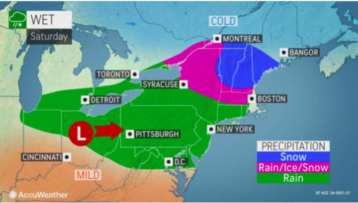
The high temperature on Christmas Day will be in the mid 40s with mostly cloudy skies and precipitation at times. For a look at areas where there will be rain (green), rain and ice (pink), and snow (blue) on Christmas Day, click on the second image above.
There's a chance for another round of precipitation Christmas night into Sunday, Dec. 26 in which areas farther north and inland could see snowfall.
Areas where snow is possible Christmas night into Sunday, Dec. 26 are shown in the third image above.
Check back to Daily Voice for updates.
Click here to follow Daily Voice Rivertowns and receive free news updates.