Find Your Daily Voice
Orangetown
Your Local News for Orangetown, New York
Saturday, apr 27
45°
Follow
News
Schools
Business
Obituaries
Police & Fire
Weather
Lifestyle
Politics
Sports
Traffic
Real Estate
Tags
Jobs
Shop
Support Us
Orangetown
Follow
Find Your Daily Voice
News
Schools
Business
Obituaries
Police & Fire
Weather
Lifestyle
Politics
Sports
Traffic
Real Estate
Tags
Jobs
Shop
Support Us
Home
About us
All sites
Advertise with us
Contact us
Terms of use
Privacy policy
Code of ethics
Site Map
© 2024 Cantata Media
45°
Saturday, apr 27
Tag:
Winter Storm Watch
Weather
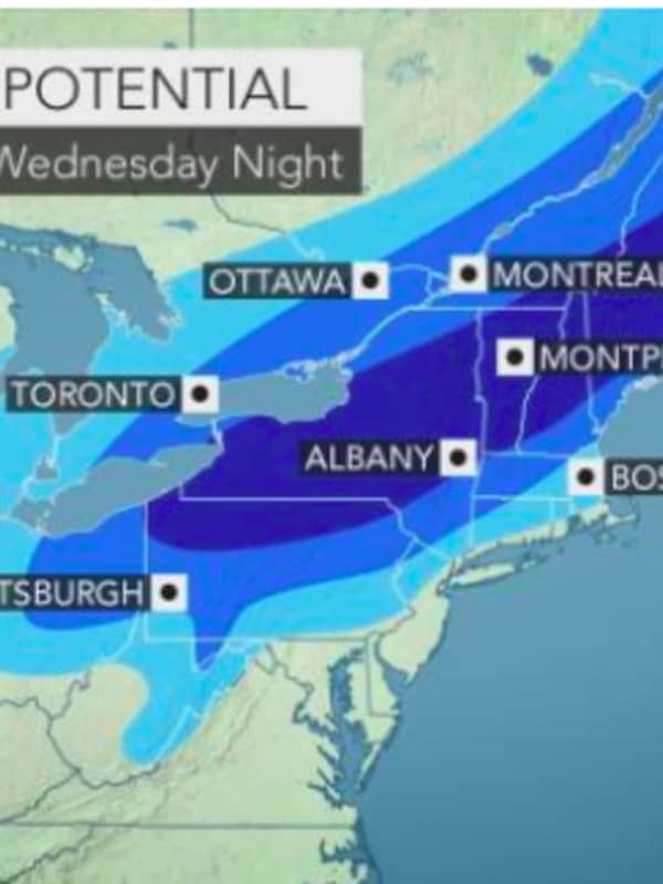
Snowfall Projections Increase For Blockbuster Storm, With 45 MPH Wind Gusts Now Possible
One of the most potent snowstorms in several years is set to slam the area with the latest forecast models calling for a foot or more of accumulation for most of the region and wind gusts of up to 45 miles per hour that could cause power outages. A Winter Storm Watch is now in effect from 2 p.m. Wednesday, Dec. 16 through 1 p.m. Thursday, Dec. 17. Travel could be very difficult to impossible during much of that time frame, the National Weather Service said in a Hazardous Weather Outlook statement issued early Tuesday morning, Dec. 15. Generally, total snow accumulations of 12…
Weather
Winter Storm Watch: Projected Snowfall Totals Released For Significant Storm Arriving Sunday
Moderate snowfall from the winter storm that moved arrived in the area overnight will taper off by mid to late morning on Saturday, March 2 after a widespread 3 to 5 inches of accumulation. As soon as the cleanup ends though, preparations will begin for the next -- and more significant -- snowstorm on Sunday, March 3, and projected snowfall totals have just been released. It is now expected to bring 5 to 8 inches of accumulation north of I-287 and the Merritt Parkway and 4 to 8 inches south of those roadways. A Winter Storm Watch has been issued for Sunda…
Weather
Significant Ice Accumulation From Major Storm Could Lead To Power Outages This Weekend
An overnight round of light snow resulted in a coating to up to an inch of accumulation on Friday morning. But that was just a very small taste of what's in store as a major storm the National Weather Service describes as "multi-hazard" comes this weekend. The storm's biggest threat will be ice, especially north of I-287 and the Merritt Parkway and just south of I-84, where a quarter-inch of ice accumulation is expected. (See first and second images above.) Coupled with wind gusts of up to 30 mph on Sunday, downed tree limbs and power lines could lead to widespread outages. The storm…
Weather
Snow, Ice Accumulation Projections Released For Major Storm That Will Follow Overnight Snow
Projected snowfall and ice accumulations for the major winter snow that will sweep through the area this weekend have been released, but a preview of that system will come with a separate system bringing light snow overnight into Friday. The back-to-back storms will be followed by a blast of Arctic Air and a dangerous wintry mix with an accumulation of ice that could cause power outages on Sunday. The first storm will come overnight Thursday night, Jan. 17 into Friday morning, Jan.18 with widespread 1 to 2 inches of accumulation. Snow is expected to arrive around 11 p.m. Thursday and …
Weather
Storm Watch: Here's The Latest As Nor'easter Takes Aim, Schools Announce Early Dismissals
Click here for an updated story: Projected Accumulations For Nor'easter Increase Again; Gusty Winds Could Cause Power Outages A Nor'easter roaring into the area Thursday afternoon will bring a mix of rain, sleet and the first accumulating snowfall of the season in a rare pre-Thanksgiving winter storm. School districts throughout the area have been announcing early dismissals during the early morning hours Thursday. Southern parts of Westchester, Rockland and Fairfield should see 1 to 2 inches of snow and sleet accumulation until the changeover to rain overnight into Friday.&…
Weather
Projected Snowfall Totals Increase As Nor'easter Roars Into Area From The South
Click here for an updated story: Storm Watch - Here's Latest As Nor'easter Takes Aim On Area, Schools Announce Early Dismissals A Nor'easter sweeping its way from the south will barrel through Washington, D.C., and Philadelphia before roaring into the area Thursday afternoon as new snowfall projections for the storm show a slight increase in accumulation. Southern parts of Westchester, Rockland and Fairfield should see 1 to 2 inches of snow and sleet accumulation until the changeover to rain overnight into Friday. North of I-287 and the Merritt Parkway, look for 2 to 4 inches of …
Weather
Winter Storm Watch: Midweek Nor'easter Could Bring 6-12 Inches Of Snow
Click here for an updated story: New Storm Snowfall Projections Increase Accumulation Range To 10-12 Inches A new winter storm now in the Upper Midwest is expected to develop into another Nor'easter bringing up to a half-foot or more of snow to the area in the middle of the workweek. The storm is moving across the country, producing blizzard conditions in the northern Plains and snow in the Midwest before becoming a coastal storm in the Northeast on Wednesday that could result in 3 to 6 inches or more of snow for much of the tristate area, according to the National Weather Service. Areas …
Weather
Projected Snowfall Totals Increase For Weekend Storm
Click here for an updated story: Half-Foot Of Snow Now Possible For Entire Area Don't let another mild day fool you, folks. A significant amount of snow is now expected to accumulate in the tristate area Saturday night into Sunday with as much as 4 to 5 inches being predicted from the quick-moving storm, according to the National Weather Service. Winter Storm Watches are in effect from early Saturday night to early Sunday morning for northern New Jersey, the lower Hudson Valley and Fairfield County. Friday will be cloudy with rain through the mid-afternoon, and the high temperature in …
Weather
Snowfall Projections Updated As Storm Nears Rockland
Tuesday morning updated report: New Update On Winter Storm: Latest Snowfall Projections Earlier report: How much snowfall should you expect from the winter storm system moving through the area Wednesday? It depends on where you are, and if you are north of I-287, get your shovels ready. Parts of Rockland and Northern Westchester could see up to 4 inches. North of I-84, even more. For Putnam, anywhere from 4 to 8 inches, Orange County 4 to 9 inches, Poughkeepsie could see 6 to 8 inches of accumulation and Pine Plains 8-12 inches. South of I-287, 1-3 inches is expected. A Winter Storm W…
Weather
Snowfall Projections Updated As Storm Nears Rockland
Tuesday morning updated report: New Update On Winter Storm: Latest Snowfall Projections Earlier report: How much snowfall should you expect from the winter storm system moving through the area Wednesday? It depends on where you are, and if you are north of I-287, get your shovels ready. Parts of Rockland and Northern Westchester could see up to 4 inches. North of I-84, even more. For Putnam, anywhere from 4 to 8 inches, Orange County 4 to 9 inches, Poughkeepsie could see 6 to 8 inches of accumulation and Pine Plains 8-12 inches. South of I-287, 1-3 inches is expected. A Winter Storm Wa…

 45°
45°