Tag:

Travel Safety

All New York Construction-Related Closures Paused For Memorial Day Weekend All New York Construction-Related Closures Paused For Memorial Day Weekend
All New York Construction-Related Closures Paused For Memorial Day Weekend Lane closures due to construction will be temporarily paused across New York State in the hopes of easing travel over Memorial Day weekend. On Thursday, May 25, Gov. Kathy Hochul announced that temporary lane closures on New York State highways will be paused to accommodate holiday travel. The construction will be suspended starting at 6 a.m. on Friday, May 26, and will last through 6 a.m. on Tuesday, May 30. "Memorial Day marks the unofficial start of the summer season, and New Yorkers across the state will be hitting the road to enjoy time with friends and family," Governor Hochul said…
NY Officials Urge Caution As Storm Expected To Bring Snow, Freezing Rain NY Officials Urge Caution As Storm Expected To Bring Snow, Freezing Rain
NY Officials Urge Caution As Storm Expected To Bring Snow, Freezing Rain New York state officials are urging residents to prepare as a winter storm is expected to bring snow and freezing rain to parts of the state. The storm is set to impact the region beginning the night of Thursday, Feb. 3, through Friday, Feb. 4.  Gov. Kathy Hochul said the Hudson Valley and downstate regions are expected to see freezing rain and icy conditions. She said parts of the Hudson Valley region may receive up to four inches of snow and up to two-tenths of an inch of ice. Parts of Central New York, the Southern Tier and the Finger Lakes could receive as much as 18 inches of sno…
High Wind Warning: Damaging Gusts Up To 70 MPH Could Cause Widespread Power Outages High Wind Warning: Damaging Gusts Up To 70 MPH Could Cause Widespread Power Outages
High Wind Warning: Damaging Gusts Up To 70 MPH Could Cause Widespread Power Outages A High Wind Warning is in effect for the potent post-Easter Storm that will hit the area. The warning starts at 6 a.m. on Monday, April 13 and lasts until 6 p.m. Monday. Sustained winds to 40 to 45 miles per hour and gusts up to 70 miles per hour could cause widespread power outages, the National Weather Service said. The overnight low temperature will hold steady in the mid 50s as a surge of mild air arrives ahead of the storm system. Rain is expected to start just before daybreak on Monday, with thunderstorm activity beginning around 9 a.m. Even sturdy and well-secured tent struct…
Storm Will Start As Snow Before Changing To Wintry Mix, Causing Potentially Hazardous Travel Storm Will Start As Snow Before Changing To Wintry Mix, Causing Potentially Hazardous Travel
Storm Will Start As Snow Before Changing To Wintry Mix, Causing Potentially Hazardous Travel The weekend winter storm that will start as snow will turn to ice and rain, creating potentially hazardous travel conditions. The entire region is expected to see snowfall sometime after 1 p.m. Saturday, Jan. 18. Areas south of I-287 in New York and the Merritt Parkway in Connecticut will see a changeover to a wintry mix of snow, sleet and rain late in the afternoon and then all rain after 8 p.m. Saturday, according to the National Weather Service. Farther north and inland, the changeover from snow to a wintry mix is expected to come several hours later. The entire region will see ra…
Projected Snowfall Totals Increase For Powerful Storm System That Will Sweep Through Area Projected Snowfall Totals Increase For Powerful Storm System That Will Sweep Through Area
Projected Snowfall Totals Increase For Powerful Storm System That Will Sweep Through Area This story has been updated. Projected snowfall totals have increased for the powerful storm that will bring a mix of snow, sleet and freezing rain to the region. The storm will arrive Monday night, Dec. 16 and continue through Tuesday evening, Dec. 17. A total of 3 inches of accumulation is now predicted for areas north of I-287 in New York and the Merritt Parkway in Connecticut, according to the National Weather Service in projections released late Monday afternoon. A total of 2 inches of snowfall is predicted for Southern Westchester and Southern Fairfield County. (See first i…
Here Are Latest Projected Snowfall Totals For Nor'easter That Will Slam Area Here Are Latest Projected Snowfall Totals For Nor'easter That Will Slam Area
Here Are Latest Projected Snowfall Totals For Nor'easter That Will Slam Area Click here for an updated story - Storm Watch: Here Are Latest Projections For Snow, Ice, Rain Accumulations, Timing 
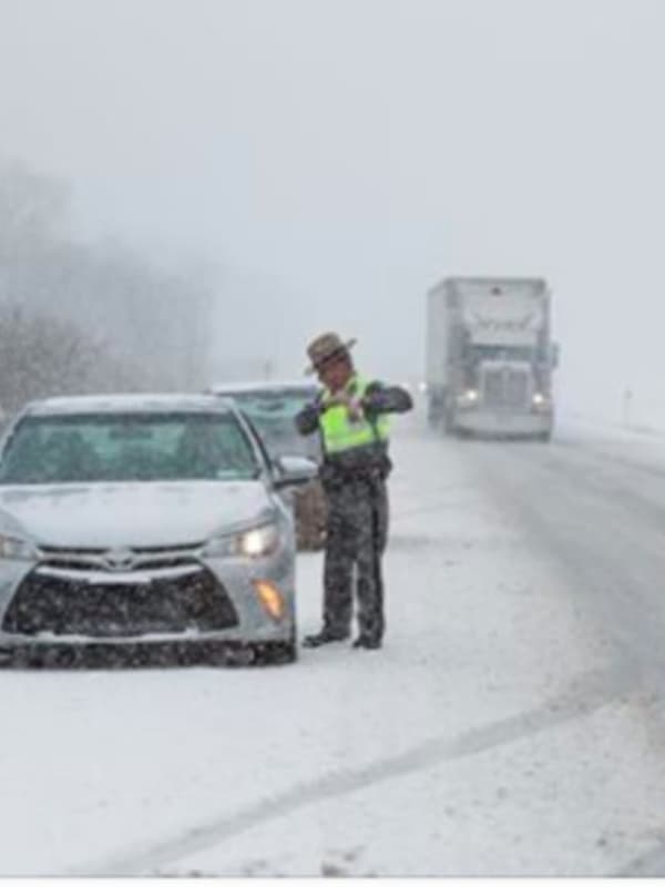
A slow-moving major Nor'easter will dump mixed precipitation along with heavy snow at times, creating dangerous and difficult travel for both those heading home from Thanksgiving on Sunday, Dec. 1 and those headed back to work on Monday, Dec. 2. Winter Storm Watches, in effect from 7 a.m. Sunday, Dec. 1 until 7 p.m. Monday, Dec. 2, now cover Northern Westchester, Putnam, Dutchess, Rockland, Orange, Ulster and Sullivan counties in New York and Northern Fairfield and L…
Winter Storm Warning: Projected Snowfall Totals Increase For Major Storm Winter Storm Warning: Projected Snowfall Totals Increase For Major Storm
Winter Storm Warning: Projected Snowfall Totals Increase For Major Storm Projected snowfall totals have been increased for the major, quick-moving storm that will sweep through the area and cause hazardous conditions for those traveling Sunday night into the Monday morning commute. It is now expected to bring about 7 inches of accumulation to the region. (See first image above.) A Winter Storm Watch will be in effect from 1 p.m. Sunday, March 3 until 7 a.m. Monday, March 4. Sunday will start off partly sunny before clouds roll in on a day in which the high temperature will be around 40 degrees. There's a 50-50 chance of rain early in the afternoo…
Dangerous Cold: New Yorkers Urged To Take Caution Ahead Of Arctic Blast, Frigid Temps Dangerous Cold: New Yorkers Urged To Take Caution Ahead Of Arctic Blast, Frigid Temps
Dangerous Cold: New Yorkers Urged To Take Caution Ahead Of Arctic Blast, Frigid Temps With temperatures ready to plunge, New York officials are warning the region to be ready to brave the cold. Several weather systems moving through the state will bring ice-cold temperatures and frigid temperatures. The Arctic blast expected to strike has prompted New York Gov. Andrew Cuomo to take emergency measures. Cuomo said that he has “directed a Level 3 activation of the State Emergency Operations Center in order to prepare for and assist with any potential emergency response activities.” Area residents are also being warned that there will be an increased risk of travel during the w…
Eye On The Storms: Here's The Latest On Back-To-Back Rounds Of Snowfall Eye On The Storms: Here's The Latest On Back-To-Back Rounds Of Snowfall
Eye On The Storms: Here's The Latest On Back-To-Back Rounds Of Snowfall Old Man Winter is about to wake up from his nap. Get set for back-to-back storms that will make it look and feel like it really is the middle of January. The first storm will come overnight Thursday night into Friday morning with widespread 1 to 4 inches of accumulation, with the higher amounts farther north. For the latest snowfall projections, see the third image above. Travel will be hazardous due to poor visibility and snow-covered roads, particularly across the interior for the Friday morning commute, the National Weather Service said.  Snow is expected to arrive around 11 …
White Christmas? There's Now A Chance Of Snow: Here's When, How Much We Could Get White Christmas? There's Now A Chance Of Snow: Here's When, How Much We Could Get
White Christmas? There's Now A Chance Of Snow: Here's When, How Much We Could Get It's beginning to look like we could have a White Christmas. There's now at least a chance for it. After earlier forecasts predicted clear skies through Tuesday, Dec. 25, the latest models released Saturday morning show there's now a chance for snow Sunday night into Christmas Eve, Monday, Dec. 24. Saturday, Dec. 22 has started out mainly cloudy, but there will be gradual clearing with mostly sunny skies in the afternoon and a high in the mid-40s. It will be windy with gusts up to 30 mph. Sunday, Dec. 23 will be much colder with partly sunny skies and a high in the mid-30s, but the wind-c…
Dividing Line: Snow, Ice Farther North, Rain For Rest Of Area Dividing Line: Snow, Ice Farther North, Rain For Rest Of Area
Dividing Line: Snow, Ice Farther North, Rain For Rest Of Area A wet, raw day will bring a mixed bag of precipitation to the area Sunday through the overnight into Monday. Areas farther north will see a wintry mix of snow, sleet and freezing rain while southern areas will see rain.  A look at the dividing line between rain (green) and a wintry mix (pink) appears in the first image above. North of I-84, precipitation will transition to mainly snow this evening before tapering off overnight. Amounts will be light but will be enough to make surfaces slick. Motorists should allow extra time for travel today and keep in mind that any untreat…
Weekend Washout? We'll See Warmer Temps, Plenty Of Rain Weekend Washout? We'll See Warmer Temps, Plenty Of Rain
Weekend Washout? We'll See Warmer Temps, Plenty Of Rain Light snow followed by temperatures hovering around the freezing mark resulted in black ice conditions in portions of the area during the Friday morning commute. Hazardous travel is possible, especially on bridges and overpasses, the National Weather Service said in a Special Weather Statement issued just before 6:30 a.m. But temperatures will steadily rise and Friday will be one of the warmest days in a while, with a high in the upper-40s. Friday will also mark the start of a stretch of rainy weather. There is a chance of light rain or drizzle Friday morning through late in the afternoon…
Storm Watch: Here's The Latest As Nor'easter Takes Aim, Schools Announce Early Dismissals Storm Watch: Here's The Latest As Nor'easter Takes Aim, Schools Announce Early Dismissals
Storm Watch: Here's The Latest As Nor'easter Takes Aim, Schools Announce Early Dismissals Click here for an updated story: Projected Accumulations For Nor'easter Increase Again; Gusty Winds Could Cause Power Outages A Nor'easter roaring into the area Thursday afternoon will bring a mix of rain, sleet and the first accumulating snowfall of the season in a rare pre-Thanksgiving winter storm. School districts throughout the area have been announcing early dismissals during the early morning hours Thursday.  Southern parts of Westchester, Rockland and Fairfield should see 1 to 2 inches of snow and sleet accumulation until the changeover to rain overnight into Friday.&…
Bed Bug Infestation Reported On Air India Flights From Newark Bed Bug Infestation Reported On Air India Flights From Newark
Bed Bug Infestation Reported On Air India Flights From Newark Passengers on multiple Air India flights out of Newark Liberty International Airport are reporting an infestation of bed bugs in the aircraft seats. Among them Pravin Tonsekar, who sat in the business class seats for a 17-hour flight Tuesday with his wife and kids. "All our seats infested with bed bugs," he said in a Tweet. "Sir , have heard of bed bugs on trains but shocked to experience on our maharaja and that too business." Air India replied with an apology. On Wednesday, Twitter user @roscrow reported bed bug bites all over his wife and kids' bodies after a flight…
Quick-Moving Storm Could Bring Accumulating Snow To Area Quick-Moving Storm Could Bring Accumulating Snow To Area
Quick-Moving Storm Could Bring Accumulating Snow To Area Click here for an updated story: Projected Snowfall Totals Increase For Storm That Will Sweep Through Area This is no early April Fool's Day joke, folks. Just when you thought it was safe to put away your snow and ice scrapers comes word that a storm system is expected to bring a return of wintry weather to the area overnight Sunday into Monday. The quick-moving low-pressure system will likely bring a light accumulating snowfall to the region, the National Weather Service said in a Hazardous Weather Statement released early Saturday morning.  The storm could result in hazardous travel c…
Travel Advisory Issued By Cuomo Includes Hudson Valley Travel Advisory Issued By Cuomo Includes Hudson Valley
Travel Advisory Issued By Cuomo Includes Hudson Valley Related stories: Schools Announce Delayed Starts, Closures For Tuesday Eye Of The Storm: Nor'easter Brings Heavy Snow, Wind As the latest round of snow begins to stick, making for slow, slippery travel conditions, Gov. Andrew Cuomo has issued a travel advisory for portions of New York, including the Hudson Valley. "I caution all New Yorkers within the path of the storm to stay off the roads unless travel is absolutely necessary," Cuomo said Tuesday morning. "Driving conditions during and after the storm will be challenging and we want to ensure that our personnel are able to …
Eye Of The Storm: Heavy Snowfall Before Storm Winds Down Early Sunday Eye Of The Storm: Heavy Snowfall Before Storm Winds Down Early Sunday
Eye Of The Storm: Heavy Snowfall Before Storm Winds Down Early Sunday Click here for an updated story: How Much Snow Did You Get? A Look At Totals From The Area A fast-moving storm system has arrived in the area, with snowfall totals expected to be more than half a foot in some spots. Snowfall accumulation of 4 to 8 inches is projected for most of the area before the system winds down early Sunday morning. Snowfall rates of 1 to 2 inches per hour are expected late Saturday night into the very early hours of Sunday morning, with visibility of less than a quarter-mile at times. The reduced visibility and snow-covered roads will make for difficult travel cond…
Freezing Rain, Drizzle Advisory Issued For Rockland Freezing Rain, Drizzle Advisory Issued For Rockland
Freezing Rain, Drizzle Advisory Issued For Rockland The National Weather Service has issued an advisory for freezing precipitation into Wednesday morning for much of the Hudson Valley. The advisory covers Northern Westchester, Putnam, Rockland and Orange. A weak disturbance southeast of the region may result in a few light freezing rain showers or patches of freezing drizzle late Tuesday night into early Wednesday morning. Travelers are advised to monitor the latest forecast before heading out. The chance for the freezing precipitation is for mainly after 2 a.m. Wednesday. There is a chance of patchy freezing drizzle with a slight chance …
Freeze-Up Following Storm Could Make For Another Slippery Morning Commute Freeze-Up Following Storm Could Make For Another Slippery Morning Commute
Freeze-Up Following Storm Could Make For Another Slippery Morning Commute A burst of Arctic air will sweep in following Wednesday's winter storm and result in a quick freeze-up that could make for more slippery travel for the Thursday morning commute. Overnight low temperatures will fall into the mid-teens, with wind-chill factors between 10 and 15 degrees. School delays and even some closings are possible. Thursday will be a sunny day but bitterly cold, with a high around 30 degrees and wind-chill values between 10 and 20. Friday will be mostly cloudy with a high around the freezing mark and a slight chance of light snow in the late afternoon and early evening…