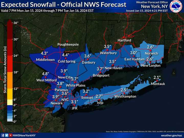
The time frame for the storm is late Monday night, Jan. 15 into early Tuesday evening, Jan. 16.
Total snow accumulations of 3 to 4 inches are now expected in much of the region, up from the earlier 2 to 3 inches of snow forecast, the National Weather Service said in brand-new predictions released around 5 p.m. Monday.
Parts of upstate New York and Western Massachusetts could now see up to around a half a foot of snow.
For snowfall forecasts by regions, click on the following images (the most snowfall is shown in areas shaded in darker blue):
- NYC metro area and coastal Connecticut: First image above.
- All of Connecticut and Massachusetts: Second image above.
- Eastern upstate New York and parts of western New England: Third image above.
"Plan on slippery road conditions," the National Weather Service said in a Winter Weather Advisory that's in effect from 10 p.m. Monday to 7 p.m. Tuesday. "The hazardous conditions could impact the Tuesday morning or evening commutes."
Wednesday, Jan. 17, and Thursday, Jan. 19 will be dry with a mix of sun and clouds on both days and the high temperature at or around the freezing mark.
The chances have increased for another winter storm on track to arrive during the day on Friday, Jan. 19 that could linger into Friday evening with the potential for accumulating snow.
There's uncertainty surrounding its potential strength and potential snowfall amounts.
Check back to Daily Voice for updates.
Click here to follow Daily Voice North Salem and receive free news updates.


