Tag:

Snow showers

New Storm System Expected To Bring Mix Of Snow, Sleet, Rain: Here's What To Expect New Storm System Expected To Bring Mix Of Snow, Sleet, Rain: Here's What To Expect
New Storm System Expected To Bring Mix Of Snow, Sleet, Rain: Here's What To Expect A new storm system is expected to bring the latest round of sleet and snowfall to the region. The time frame for the storm is from just after midnight on Monday, Feb. 7 until the early morning hours of Tuesday, Feb. 8. Though it's a 24-hour window, the good news is that a climb in temperatures during the day Monday means most of the precipitation will be in the form of rainfall, and no more than a coating of snow is expected. Sunday, Feb. 6 will be a clear and cold day with a high temperature in the upper 20s and wind-chill values in the teens (see the image above.) Clouds will thicken Su…
End-Of-Thanksgiving Weekend Storm Could Be First Of Several Snowmakers In Northeast End-Of-Thanksgiving Weekend Storm Could Be First Of Several Snowmakers In Northeast
End-Of-Thanksgiving Weekend Storm Could Be First Of Several Snowmakers In Northeast A widespread storm at the end of Thanksgiving weekend from a Clipper system moving from west to east could be the first of several snowmakers in the Northeast in the days to come, according to a new report. "These storms tend to organize over the western provinces of Canada and are dubbed Alberta clippers due to their fast movement and origin," AccuWeather says. The time frame for the first clipper system taking aim on the region is Sunday night, Nov. 28 into the early overnight hours before skies begin to clear prior to dawn on Monday, Nov. 29. For a look at areas expected to see a m…
Topsy Turvy Thanksgiving Week Now Expected To Bring First Snowfall Of Season Topsy Turvy Thanksgiving Week Now Expected To Bring First Snowfall Of Season
Topsy Turvy Thanksgiving Week Now Expected To Bring First Snowfall Of Season Thanksgiving week has started with the arrival of a cold front that will lead to a drop in temperatures, and it could end with many seeing snowflakes for the first time this season. Rain and showers will end with the passage of the front on Monday morning, Nov. 22, with gradual clearing in the afternoon. Temperatures will also slowly fall during the afternoon as colder air settles in. Between a quarter-inch and a half-inch of rainfall is expected from overnight Sunday into Monday. Brisker conditions and strong wind gusts of 30 to 40 miles per hour are in store for most of the region o…
Strong Wind Gusts Could Cause Power Outages As Cold Front Will Bring Chance Of Snow Showers Strong Wind Gusts Could Cause Power Outages As Cold Front Will Bring Chance Of Snow Showers
Strong Wind Gusts Could Cause Power Outages As Cold Front Will Bring Chance Of Snow Showers The active weather pattern that marked the month of February is continuing right into March. Two days of on and off rain will end late Monday morning, March 1, followed by an Arctic cold front that will push through the region, bringing strong, gusty winds, brutal wind chill, and a chance for snow showers and squalls.  A Wind Advisory has been issued for most of the region from 4 p.m. Monday into 6 a.m. Tuesday, March 2. During that time, winds will be out of the northwest at 15 to 30 miles per hour with gusts up 50 mph. "Gusty winds could blow around unsecured objects," th…
Storm Knocks Out Power To More Than 100,000 In Hudson Valley Storm Knocks Out Power To More Than 100,000 In Hudson Valley
Storm Knocks Out Power To More Than 100,000 In Hudson Valley 
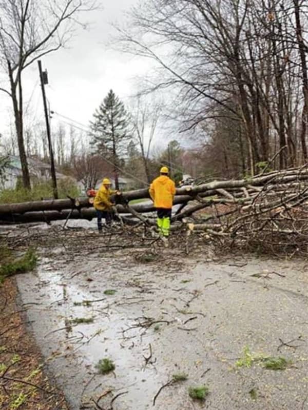
A powerful storm system bringing heavy downpours and damaging winds has resulted in numerous downed tree limbs, leading to road closures and more than 100,000 power outages in the Hudson Valley. Here are the number of customers without power just before 8:15 a.m. on Christmas Day, Friday, Dec. 25 by utility company (click on each link for breakdowns by community): Con Edison - 17,598 NYSEG - 24,469 Central Hudson - 33,163 Orange & Rockland County - 26,107 In areas hardest hit, residents are being urged to avoid travel Christmas morning to allow utility crews to clear roadways …
Cold Front Will Bring Damaging Wind Gusts Of Up To 55 MPH That Could Cause Power Outages Cold Front Will Bring Damaging Wind Gusts Of Up To 55 MPH That Could Cause Power Outages
Cold Front Will Bring Damaging Wind Gusts Of Up To 55 MPH That Could Cause Power Outages It's now November, but the arrival of a cold front will make it feel more like it's December, and will bring with it strong wind gusts of up to 55 miles per hour that could cause power outages. There will be a chance of showers on Sunday, Nov. 1, with rain becoming more likely and widespread in the evening as the cold front approaches.  Sunday will be mostly cloudy and warmer, with a high temperature in the mid 50s. Showers should arrive early in the afternoon Sunday, followed by rain, which could be heavy at times, through the early evening and more showers later in the evening. Win…
Here's When We Could See Snow On A Seasonably Cold Weekend Here's When We Could See Snow On A Seasonably Cold Weekend
Here's When We Could See Snow On A Seasonably Cold Weekend The strong storm system that brought with it gusty winds and caused thousands of power outages and plenty of road closures also led to a sharp drop in temperatures. With it will come two separate chances for some snow over the weekend. Saturday, Feb. 8 will be sunny but cold with a high temperature in the low to mid 30s north and inland with wind-chill values between 10 and 20 degrees. Farther south, Saturday's high will be near 40 degrees with the wind-chill factor between 15 and 25. The overnight low temperature will be in the mid 20s under mostly cloudy skies. With the temps …
Storm Track: Here's Latest Projected Path, Timing For Weekend System Storm Track: Here's Latest Projected Path, Timing For Weekend System
Storm Track: Here's Latest Projected Path, Timing For Weekend System A storm system moving northeast is now projected to pass well south of the region.  Friday, Jan. 31 will be a cloudy and dry day with a high temperature of around 40 degrees and wind-chill values between 30 and 40 degrees. As the storm moves northeast (see image above), there will be a slight chance of rain and snow late Friday night through the overnight. There could be snow showers until around 10 a.m. Saturday, Feb. 1, followed by a chance for rain showers through the early afternoon on a cloudy day with the high temperature in the low 40s. There will be another chance for snow sh…
Scattered Snow Showers, Flurries Possible To Start Workweek With Storm Threat For Weekend Scattered Snow Showers, Flurries Possible To Start Workweek With Storm Threat For Weekend
Scattered Snow Showers, Flurries Possible To Start Workweek With Storm Threat For Weekend Click here for an updated story: Potential Nor'easter Takes Aim On Area Just In Time For Groundhog Day Scattered snow showers and flurries are possible for much of the region to start the workweek, with the possibility of a winter storm looming for the weekend. The time frame for flurry activity is Monday morning, Jan. 27 through around 11 a.m. for areas south of I-287 in New York and the Merritt Parkway in Connecticut, where sprinkles and light rain will also be possible. North of those areas, the snow chance will last until the early afternoon Monday as the high temperature star…
Rainstorm Will Be Followed By Return Of Wintry Weather, Some Snow Rainstorm Will Be Followed By Return Of Wintry Weather, Some Snow
Rainstorm Will Be Followed By Return Of Wintry Weather, Some Snow Wintry weather will return in the second half of the weekend with blustery conditions and wind-chill values below the freezing mark, leading the way to a new storm system that will bring some snow to the region. Here's the five-day forecast: Saturday, Jan. 4: Steady morning rain will become more scattered with mainly light rain and drizzle in the afternoon. The high temperature will be in the low 40s.  There will be showers at times during the evening and in the early overnight hours. The low temperature will be around 34 degrees south of I-287 in New York and the Merritt Parkway…
Wild Weather Week: Damaging Winds, Power Outages, Plus Some Snow Wild Weather Week: Damaging Winds, Power Outages, Plus Some Snow
Wild Weather Week: Damaging Winds, Power Outages, Plus Some Snow Get set for a rocky week weather-wise and a cold finish to February.  It's starting off with winds of 25 to 35 mph with gusts near 65 miles per hour, leading to a High Wind Warning in effect 6 p.m. Monday, Feb. 25. (See first image above.) Hundreds of outages have already been reported throughout the region with more expected late Monday morning into the early afternoon. (Check back for separate outage updates from Daily Voice.) Monday will be partly cloudy with a high around the freezing mark and winds whipping through the region throughout the day, bringing down trees and tree limbs…
New Accumulation Projections: Here's What Areas Will Get The Most Snowfall New Accumulation Projections: Here's What Areas Will Get The Most Snowfall
New Accumulation Projections: Here's What Areas Will Get The Most Snowfall New snowfall projections for the complex storm that will sweep through the Northeast show widely varying totals, with parts of the region seeing up to nearly half a foot but areas farther south and east expected to get just an inch or less of accumulation. Higher accumulations will be farther north and west. (See first image above.) Dutchess County should get about 3 inches of accumulation, but more than a foot is expected is parts of upstate New York. (See second image above.) A Winter Weather Advisory is in effect for much of the area from 6 a.m. Tuesday, Jan. 29 until 6 a.m. We…