Find Your Daily Voice
 44°
44°
Here Comes Fred: Storm Will Bring Downpours, Localized Flooding, Isolated Tornadoes Possible
The remnants of Fred, which is now a Post-Tropical Cyclone, will bring locally heavy rainfall and localized flash flooding to the region, with isolated tornadoes possible.
The time frame for the main brunt of storm activity in the area will be Wednesday night, Aug. 18 into around noontime Thursday, Aug. 19.
For a look at the latest projected track and timing for Fred, see the first image above.
The highest chance for flooding will be to the north and west. (Click on the second image above.)
Generally, 1 to 2 inches of rainfall is now expected in this area, with locally high…
Severe Thunderstorm Watch In Effect For Parts Of Region With Strong Winds, Tornadoes Possible
A Severe Thunderstorm Watch has now been issued for parts of the region.
It lasts until 11 p.m. Monday, June 21, and covers Dutchess, Ulster, Sullivan, Greene, Albany, Columbia, Delaware, Otsego, Rensselaer, and Schenectady counties in New York, Litchfield County in Connecticut, and Berkshire County in Massachusetts.
Torrential rainfall is possible during storm activity. Large hail of 1 inch in diameter or greater, damaging winds, and an isolated tornado or two are the main threats, said the National Weather Service, which issued the watch.
More storms are expected again on Tuesd…
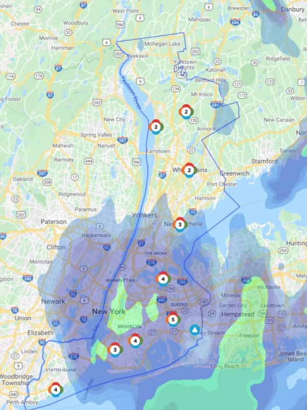
Line Of Strong Storms With Gusty Winds Knock Out Power In Westchester
Hundreds in Westchester have been left without power as a line of storms bringing gusty winds and heavy rain swept through the area.
As of 3:30 p.m. on Thursday, April 9, there were 13 reported outages in Westchester, Con Edison announced, impacting 418 of its 348,198 customers. An additional 40 NYSEG customers in Westchester were without power.
Of the Con Edison customers, 240 outages were reported in New Rochelle, followed by Mount Pleasant (82 outages), Sleepy Hollow (37); Scarsdale (29), New Castle (12), and Briarcliff Manor. Other municipalities reporting outages were: Greenburgh, Moun…