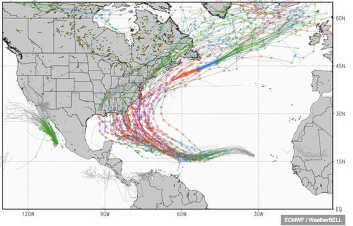
New data released by the European Centre for Medium-Range Weather Forecasts making up a "spaghetti model" (so called because the numerous possible paths look like spaghetti strands) shows the majority of possible paths for Irma, which became a Category 3 hurricane on Thursday, have it taking a northerly path up the East Coast after concluding its westerly trek somewhere in the area of south Florida.
Irma will take about a week to make its trek westward across the Atlantic and meteorologists will likely be tracking this storm through the middle of September, according to AccuWeather Hurricane Expert Dan Kottlowski.
"There is the potential for Irma to ramp up to an even more powerful hurricane this weekend," Kottlowski said. "While fluctuation in strength is likely, we expect Irma to become a Category 4 well before it reaches waters near the Lesser Antilles."
A Category 4 hurricane has sustained winds of 130-156 miles per hour.
According to info from the National Hurricane Center on Saturday, Irma is moving west at 15 miles per hour with sustained winds of 110 mph.
Subtle changes in water temperatures and atmospheric conditions, such as slightly drier air and a small patch of strong winds aloft, can cause significant fluctuations in strength in even the strongest of hurricanes.
Indeed, nothing is certain as far as Irma's path goes. As the "spaghetti model," shows, it's still possible the hurricane may end its westerly trek in the open waters and trek north while still out to sea.
"At this early stage, it is unclear whether a non-tropical storm will draw Irma toward the U.S., push it away or miss affecting it entirely prior to the middle of the month.," Kottlowski said.
Check back to Daily Voice for updates.
Click here to follow Daily Voice Armonk and receive free news updates.

