Earlier report:
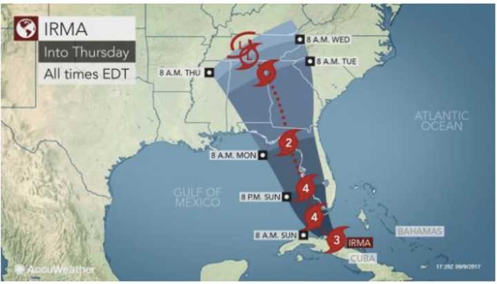
The eye of what has been described as potentially the most powerful hurricane to hit the United States is now expected to head up Florida's west coast, rather than the middle.
While this means highly populated Miami and Fort Lauderdale may be spared catastrophic damage, Hurricane Irma will result in tropical storm conditions throughout the entire peninsula and storm surges of up to 15 feet along the west coast, coupled with damaging winds.
Irma was centered about 145 miles southeast of Key West, Florida, at 2 p.m. Saturday, moving just north of due west along the north coast of Cuba at near 9 mph, packing winds of 143 mph.
After the center of Irma tracked along the northern coast of Cuba Saturday morning, Irma became a Category 3 hurricane. It is expected to regain strength in the 90 miles of warm, open water between Cuba and the Florida Keys.
"Irma remains a very powerful and destructive hurricane," AccuWeather Hurricane Expert Dan Kottlowski said.
Irma is projected to be at Category 4 strength when it makes landfall initially across the Keys and then southwest Florida on Sunday morning. Wind gusts past 140 mph in these areas could lead to catastrophic damage.
"Impacts within the projected path of Irma include life-threatening wind, storm surge and flooding rainfall hazards," Kottlowski said.
Check back to Daily Voice for updates.
Click here to follow Daily Voice Armonk and receive free news updates.

