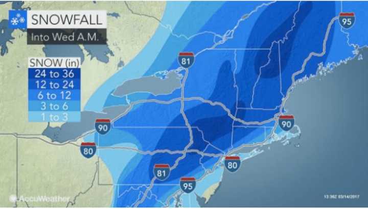
Newly released snowfall projections by both AccuWeather.com and the National Weather Service show higher accumulation amounts -- even up to two feet or more -- in areas farther north and west with about a foot or less of accumulation now expected in New York City. Long Island is expected to see 6 inches or less of accumulation. (See chart above.)
A Blizzard Warning is in effect until midnight Wednesday for Northern Westchester, Rockland, Putnam and Dutchess. During that time, the National Weather Service urges residents not to travel, saying in a statement: "Do not travel. If you must travel, have a winter survival kit with you. If you get stranded, stay with your vehicle."
Blizzard Warnings that had been in effect for Southern Westchester, Southern Fairfield and Northern New Jersey were lifted Tuesday morning around 9:30 a.m.
Dutchess County is in the "red zone" for high snowfall accumulations, with up to 25 inches expected, according to the National Weather Service.
Snow, which arrived in the pre-dawn hours, will become heavy at times, with snowfall rates of up to 2 to 3 inches per hour possible during the late morning and early afternoon north of I-287. It will continue through the evening in areas north and west, but taper off farther south in the afternoon.
New York Gov. Andrew Cuomo declared a State of Emergency that took effect midnight Tuesday covering all 62 counties in New York.
Metro-North service was shut off in and out of Grand Central at noon.
Cuomo also directed non-essential state employees impacted by the winter storm to stay home from work on Tuesday without having to charge accruals.
MTA express subway service was suspended after the rush hour Monday night in order to store trains underground on those tracks. Beginning at 4 a.m. Tuesday, above-ground service on the subway was also be suspended.
In Westchester, all Bee-Line Bus service is suspended until further notice.
Wednesday will be mostly cloudy with a high only reaching 30 and scattered snow showers after 11 a.m.
After mostly sunny but brisk days Thursday and Friday, there's a chance of some more snow Saturday.
Click here to follow Daily Voice Armonk and receive free news updates.


