Find Your Daily Voice
Pascack Valley
Your Local News for Pascack Valley, New Jersey
Saturday, apr 27
45°
Follow
News
Schools
Business
Obituaries
Police & Fire
Weather
Lifestyle
Politics
Sports
Events
Real Estate
Tags
Jobs
Shop
Support Us
Pascack Valley
Follow
Find Your Daily Voice
News
Schools
Business
Obituaries
Police & Fire
Weather
Lifestyle
Politics
Sports
Events
Real Estate
Tags
Jobs
Shop
Support Us
Home
About us
All sites
Advertise with us
Contact us
Terms of use
Privacy policy
Code of ethics
Site Map
© 2024 Cantata Media
45°
Saturday, apr 27
Tag:
Coastal Flooding
Weather
Drenching Rain, 45 MPH Winds: New Storm Moving Toward Northeast
Forecasters are warning of a weekend storm bringing widespread rain and gusty winds to the Northeast, creating yet another flood risk. Thursday, March 7 will be be mild with scattered showers while Friday, March 8 will be mostly sunny with temps in the mid-50s, forecasters say. Saturday, March 9 is when the new storm will begin moving into the region with rain beginning in the afternoon and lasting overnight, according to the National Weather Service. About an inch of rain is expected to fall, which the National Weather Service says isn't much, but given an already-wet ground "there is pot…
Weather
Murphy Urges NJ Residents Work From Home, Stay Off Roads Ahead Of Winter Storm
New Jersey Gov. Phil Murphy is urging residents to stay off the roads ahead of a winter storm expected Monday, Feb. 12 into Tuesday, Feb. 13. The National Weather Service was predicting up to 18 inches of snow in the northernmost part of the state, with between 6 inches and a foot possible across Sussex, Warren, Morris, Hunterdon, Somerset, Passaic, Bergen, and western Essex counties, where a Winter Storm Warning was issued. Murphy said the most intense stretch of precipitation, beginning as rain and turning to snow, will happen in the middle of the night and run into mid-morning…
Weather
Foot Of Snow Could Fall In Bergen County In Major Storm, NWS Says
The National Weather Service says parts of New Jersey and Pennsylvania could see more snow than what was initially predicted due to a shift in the storm track. In an updating briefing published Monday, Feb. 12, the NWS said 12 to 18 inches of snow could fall in parts of Sussex County, NJ and the Pocono Mountains. ALSO SEE: North Jersey School Closed, Delayed Ahead Of Major Winter Storm The weather map shows between 8 and 12 inches expected in parts of Bergen, Morris, Passaic, Essex, Warren, Somerset and Hunterdon counties, where winter storm warnings have been issued. Winter weather a…
Weather
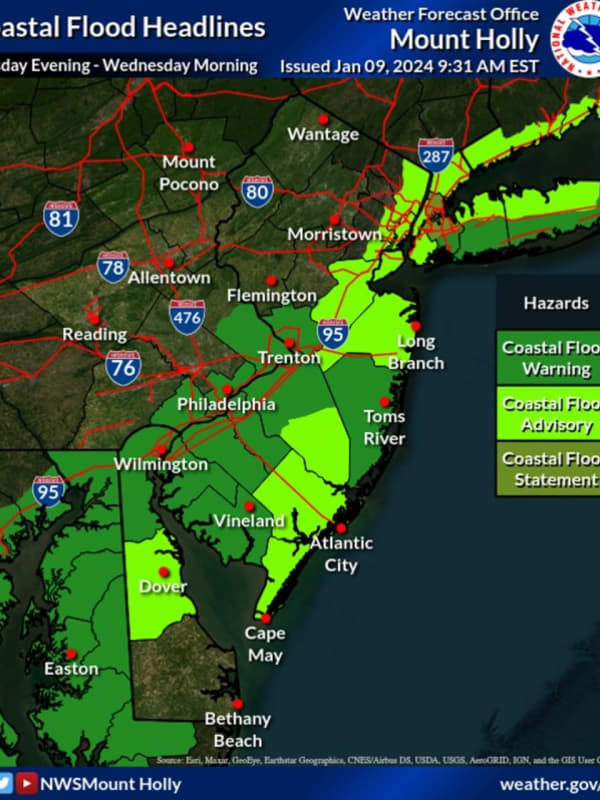
Hundreds Without Power In Bergen County As Storm Intensifies
Thousands of New Jersey residents were without power as of Tuesday evening, Jan. 9, as the storm intensified. A State of Emergency ordered by Gov. Phil Murphy went into effect at 5 p.m., with state and local officials urging residents to stay off the roads. As of 7:25 p.m., more than 2,000 residents in Hunterdon County were in the dark, according to JCP&L, including 123 in Delaware; 729 in Lambertville City; 733 in Raritan; 437 in West Amwell, and more. In Morris County, 3,360 JCP&L customers were without power. Those are residents of Mount Olive where 2,449 people w…
Weather
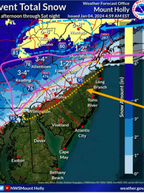
New Forecast Map: 7 Inches Of Snow Could Fall In Parts Of NJ This Weekend
Some parts of New Jersey and the Lehigh Valley/Pocono mountains could get up to seven inches of snow this weekend, according to newly-released forecast maps. The National Weather Service's Mount Holly office released a new forecast map on Thursday, Jan. 4 — two days before heavy snow is expected to make its debut after nearly two years in the Northeast. ⚠️❄️ A coastal system will bring widespread precipitation to our region. Snow and some mixed precip will occur northwest... Posted by US National Weather Service Philadelphia/Mount Holly on Thursday, January 4, 2024 ⚠️ A lot of …
Weather
Warm Start To Spooky Season Expected After NJ Can Get Itself Out From Under Water
We're going from one wacky weather pattern to another this weekend. New Jersey has one more day of drizzle before the skies begin to clear up, forecasters say. And when they do, the region will be in for another type of unseasonable weather. On Saturday, Sept. 30, several homeowners, particularly along the Jersey Shore, were left with several feet of water, which also lingered on roadways across the state. The rest of the day will be cloudy and cool, and not nearly as bad for precipitation, the National Weather Service says. Lingering coastal flooding with times of high-tide could make it…
Weather
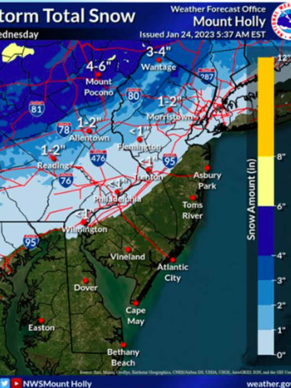
First Storm Of Season Bringing Snow, Gusty Winds To Much Of NJ, Eastern PA
The first storm of the season is shaping up for parts of New Jersey and eastern Pennsylvania, with snow and gusty winds expected all day Wednesday, Jan. 25. The National Weather Service issued a winter weather advisor for Morris, Sussex, Warren, western Passaic counties, Berks, Lehigh, Monroe and Carbon counties, from 7 a.m. to 7 p.m. Summary of weather hazards for the Wednesday winter storm. Snow, mixed precipitation, strong winds, coastal flooding, and marine impacts area all expected. Posted by US National Weather Service Philadelphia/Mount Holly on Tuesday, January 24, 2023 The wes…
Weather
Weekend Washout? Here's The Latest Memorial Day Weather Outlook
Well, it wasn't the Memorial Day holiday weekend most of us hoped and planned for. Cloudy skies, blustery, howling winds, on-and-off-showers -- none of the sights we usually see this time of year. Near record cold-high temperatures are expected, with highs in the 50s and lows in the 40s, the National Weather Service's Mount Holly office says. Continued drizzle is likely Sunday, possibly tapering off at night. Light winds Saturday and coastal flooding are both likely, forecasters say. "If the official high temperature in Philadelphia and Washington D.C., does not make it out of the lower …
Weather
Latest Snowfall Predictions, Timing Of Powerful Winter Storm Headed To NJ, PA This Afternoon
New Jersey and Pennsylvania are expected to see the first winter storm Wednesday afternoon into Thursday morning. Precipitation will begin early Wednesday afternoon in South Jersey, then head north to Central Jersey and Philadelphia, where 6 to 12 inches of snow are predicted, the National Weather Service says. Strong winds and heavy sleet were likely across South Jersey and Philadelphia, with a chance of rain leading along the Jersey Shore. Coastal flooding was possible, especially late Wednesday night and early Thursday morning, meteorologists say. Snowfall is expected to begin in N…
Weather
Here's New Projected Timing, Track For Hurricane Teddy, How It Will Affect Parts Of Region
Hurricane Teddy's latest projected path takes the center of the storm well east of the region, but it will still be felt in parts of the area. Minor to moderate coastal flooding (from half a foot to 2 feet of inundation depending on location) is expected at the times of high tide through Sunday afternoon, Sept. 20. Additionally, high surf of 8 to 12 feet and dangerous rip currents at ocean beaches will also occur, the National Weather Service said. Earlier report - Teddy Strengthens Over Atlantic, Expected To Be Major Hurricane Teddy was one of the final named storms from the English…
Weather
Latest Update On Timing, Strength Of Nor'easter Barreling Toward The Area
Click here for an updated story: Eye On The Storm: Here's What To Expect And When Nor'easter Roars Through Area As Hurricane turned Tropical Depression Willa dumps rain on the south while barreling north, more details on the timing and strength of the Nor'easter that will hit the area this weekend are emerging. On Friday, Mid-Atlantic states will see Gale-force winds at the coast of between 40-45 mph that could cause power outages and widespread heavy rain with flooding possible. The storm will rapidly make its way up the coast before arriving in the tristate area around midnight. Rain wi…
Weather
Weather Whiplash: Cold Front Will Bring Dramatic Temperature Drop, Rain
Click here for an updated story: Stormy Sunday, Monday: Cold With Rainfall Up To 3 Inches, Coastal Flooding, Freezing Rain Farther North Enjoying this spring-like Saturday? It may be a while till you have that chance again. A cold front will move through starting later in the afternoon Saturday, bringing a sharp drop in temperatures by the evening, according to the National Weather Service. Temperatures that reached highs in the low 70s in the early afternoon will drop to the 40s and 50s by nightfall. Temperatures will continue to fall thereafter into the 30s and 40s. Light rain is li…
Weather
New Nor'easter's Heavy Snow, Strong Winds Could Cause Power Outages
Click here for an updated story: Projected Snowfall Totals Increase As New Nor'easter Nears While some uncertainty still remains about the potential amount of snowfall from the fourth Nor'easter to hit the region this month, the heavy, wet snow, combined with strong winds, could lead to new power outages and tree damage. Winds will gust 30 to 35 mph along the coast during the height of the storm on Wednesday, 25 to 30 mph inland and 25 mph or less farther north. (See second image above.) Coastal flooding and beach erosion are also likely. Still, this will not be a powerhouse storm in terms…
Weather
Latest Storm Update: Timing Of Snowfall, New Accumulation Projections
Click here for an updated story: Whiteout! Monster Storm Will Bring Foot Or More Of Snow To Most Of Area The latest Nor'easter to slam the area will be most potent during the daytime hours Wednesday with the heaviest snow and strongest wind gusts from late morning through late afternoon. Snow will begin overnight with up to 2 inches of accumulation possible by daybreak before becoming heavy later in the morning, with the brunt of the snow falling between 10 a.m. and 6 p.m. Winds of 20 to 30 mph will gust to 50 mph along the coast at that time, possibly causing power outages. Snow will end …
Weather
New Storm Will Be Strongest Nor'easter Since January 'Bomb Cyclone'
Click here for an updated story: Flood Watch Issued As Nor'easter Nears Area Get set for the strongest storm since the "Bomb Cyclone" from early January as the area could see Nor'easter-type conditions on Friday. While this storm will fall short of the Bomb Cyclone's intensity and will not be as cold, it will still pack a wallop, according to AccuWeather.com. Wind gusts of 50 miles per hour or more are possible along the coast Friday night with beach erosion and coastal flooding possible. Light rain will arrive late in the afternoon Thursday and continue overnight into Friday …
Weather
Nor'easter Approaching Area Reaches 'Bomb Cyclone' Status
While the East Coast gears up for the rapidly approaching Nor'easter that’s expected to pummel the area overnight, locals can also expect to experience another weather phenomenon known as a “bomb cyclone.” The National Weather Service has predicted that the region may see anywhere from 2 to 4 inches of snow, with the storm expected to hit the area beginning around 1 a.m. on Thursday morning. According to the National Ocean and Atmospheric Administration, “bombogenesis, a popular term used by meteorologists, occurs when a mid-latitude cyclone rapidly intensifies, dropping at least 24 milliba…