CLIFFVIEW PILOT EXCLUSIVE REPORT: Massive power outages and flooding will likely continue past midnight tonight, as New York runoff swells the already overflowing Hackensack River, Pascack Brook and area reservoirs, making an already bad situation much worse, Bergen County leaders told mayors and other government officials during a 15-minute emergency conference call this afternoon. READ MORE ….
Two firefighters were injured in a pre-dawn Hillsdale gas station blaze, a tree fell through a house in Ridgewood, the Pascack Brook has overflowed its banks, floodgates are open at the Woodcliff Lake reservoir and streets in low-lying areas have become rivers. A tree fell through a house at 492 Westbrook Road in Ridgewood. No details were immediately available.
In Westwood, the Prospect Avenue bridge is under water and the entire Harding Avenue area is flooded.
CLIFFVIEW PILOT has an amazing array of photos from FDU grad Jayme Lisiewski, who has been on top of the storm out of Hoboken since the first clouds rolled in. These include shots from Hoboken Terminal, Waterfront Park and several streets in town. SEE MORE….
River Drive in Elmwood Park is closed from Willow Street to the Fair Lawn border. New Bridge Road in New Milford is closed west of River Road. Sporadic outages have been reported, and the town DPW superintendent says the sewer system is about to overflow. Police Chief Frank Papapietro told CLIFFVIEW PILOT he’s relieved that 21 families “heeded our request and self-evacuated.” Route 80 is flooded out in several areas, including the Summit Avenue/Route 17 exit in Hackensack, the River Road exit in Elmwood Park, and the Route 120/Paterson Plan Road exit in East Rutherford — where a downed pole is reported, State Police said.
Forget about Route 46 as an alternative: East Union Avenue in East Rutherford is shut down, as are the areas around the Little Ferry circle and west of Summit Avenue in Lodi. A few trees are down in Fair Lawn. Wagaraw Road is flooded.
“We’re far from being out of the woods,” Papapietro told CLIFFVIEW PILOT at 6:30. “Everyone everywhere tonight — police department, fire departments, EMS, DPWs — did some job, but there’s no sign that many of them can go home yet.”
Residents, as well, are bracing for the worst — especially with reports of high winds headed our way and the accumulation of rain through the night sending streams, and in some cases, torrents of water down highways as well as local roads.
“Small branches are down on our street,” said Tracy Feely Glock of Washington Township, just below the Woodcliff Lake reservoir. “The kids and I are all set up in the basement just in case. We have water pouring in through our fuse box already.” “We contained it with one of the 50 tupperware bins purchased to prepare for the storm….,” she told CLIFFVIEW PILOT, just after 3 a.m.“We set up the towel dam around the permiter of our basement. Just moved the big guys comic book collection in case the water starts seeping through.”
“Leaning trees in Teaneck: I actually think they’re ‘down’ and just being propped by other trees,” Tamira Sperling told CLIFFVIEW PILOT. “Too dark to tell.”
Sperling
, a marketing expert and former broadcast producer, said she’s “never seen wind this fierce, and cannot fathom that it’s going to get several times worse than this.”281,014 power outages were reported throughout New Jersey, as of 3:30 a.m. But daylight is no longer just peeking, and Irene will soon be peaking. The big hit will begin with a storm surge of 4 to 8 feet above ground level along the Atlantic — one day short of six years since Hurricane Katrina crashed into southeast Louisiana.
Here’s the catch: Storm surge is the leading coastal killer in hurricanes. And: We’re headed toward a new moon, which means an abnormally high tide right about now.
And get this: A tornado wouldn’t shock anyone.
In a phrase: The worst is yet to come.
“Hurricane Irene will become one of the more destructive tropical cyclones to hit the East Coast in at least several decades,” The Weather Channel warns. And while it may “only” be a Category 1 hurricane, “it remains large and formidable, somewhat akin to Hurricane Ike in 2008 when it made landfall. We remain very concerned about life-threatening storm surge, damaging winds, and flooding rainfall riding up the East Coast through Sunday.”
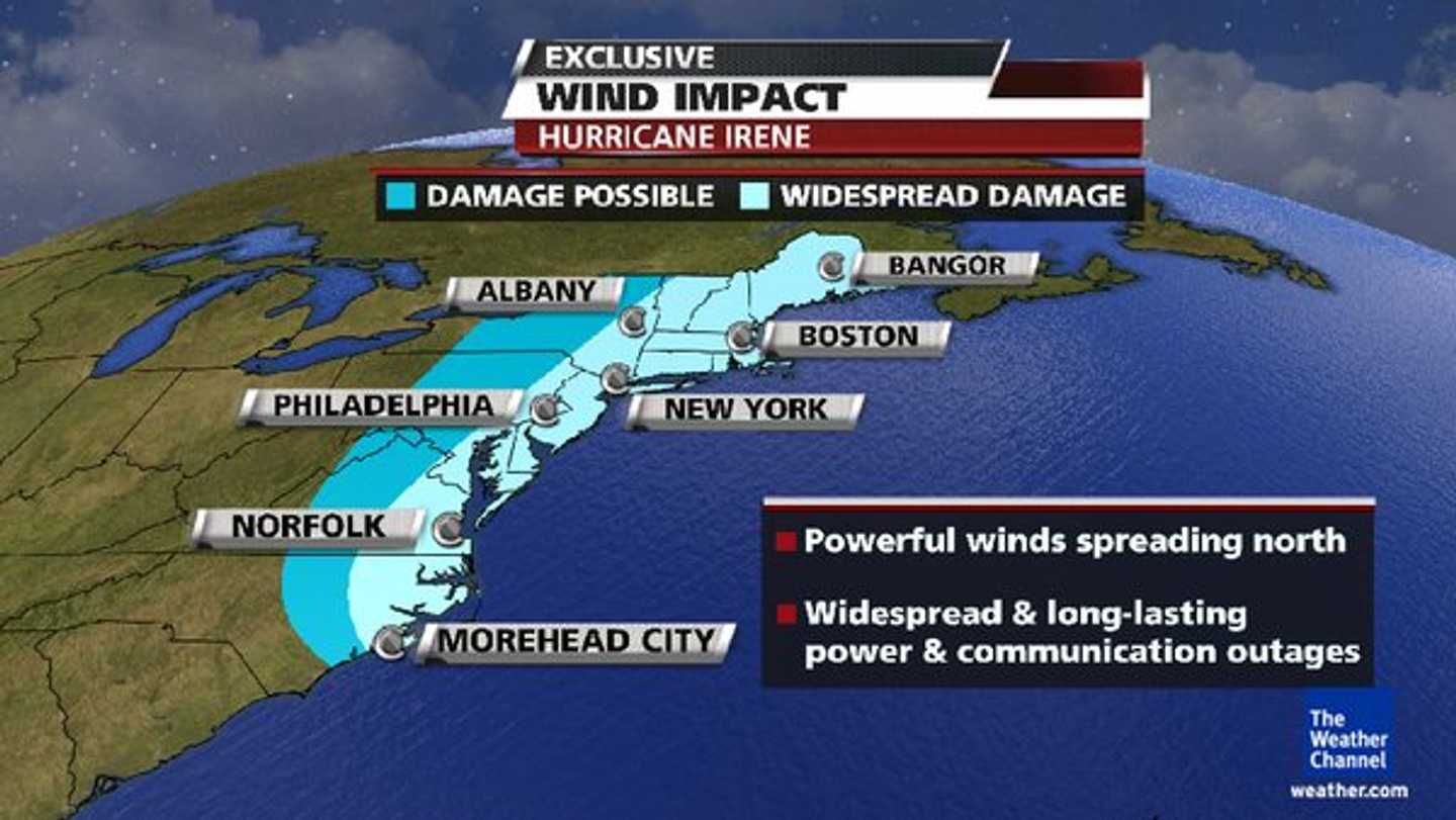
Irene’s last reported wingspan was up to 500 miles, its winds topping 110 mph, according to Weather Channel meteorologists. Trace a fairly straight line northeast along the Jersey coast and you’ll see how Bergen, Hudson and areas above will get popped not only with winds of 55 to 75 miles an hour but also up to a foot of rain.
Bergen ordinarily floods at 3 inches. It’s worse in Westwood, Hillsdale and other low-lying areas. August’s record rainfall has weakened tree roots, which could mean not only the risk of damage but severe power outages.
As local municipalities catch their collective breath, if for just a moment, Bergen County’s command center in Mahwah is gearing up to be at full capacity before 8 a.m. Reports so far have been expected. Intense planning, under Bergen County Emergency Management Coordinator Dwane Razzetti, has kept a relative lid on any serious trouble.
“Everyone everywhere — police departments, fire departments, EMS, DPWs — have done a heck of a job so far. But there’s no sign of too many going home yet,” Papapietro told CLIFFVIEW PILOT.
“Nobody outside of emergency workers and military personnel knows what it feels like to leave your home and family behind on days like this to serve others,” the veteran chief added. “Luckily we are the kind of people who watch out for our own so that people can do their jobs secure in the knowledge that there’s a whole network of people looking out for your family.
“Very few outside of us have that network and the comfort level that it brings,” he said. “It’s nights like this that I thank God I chose this profession.”
The Little Ferry circle was one of Bergen’s first areas to flood, as usual. And good ol’ Route 1/9 closed early at Secaucus Road. All of Staten Island and parts of Hoboken, New York City and Long Island have been or are being evacuated.
The NJSP also reported:
- A roof collapsed on Ocean Avenue in Long Branch, but no one was hurt. The people living there were taken to a shelter;
- Emergengy crews rushed to a cluster of senior community trailer homes in Atlantic County’s Buena Vista, where rising water trapped nearly three dozen people;
- Oyster Creek has shut down as a precaution. Salem/Hope Creek remains at 100% power.
All told, nearly 1 million people have been shuttled off Long Beach Island and just about all of Cape May and Atlantic counties. And AC’s casinos are all closing for only the third time since gambling there was legalized in 1978.
Further north, the floodgates at Pompton Dam were closed in the middle of the night as the flow rate on the Ramapo River began increasing.
Let’s step back a moment, for perspective: In the past 160 years, the centers of only FIVE hurricanes passed within 75 MILES of New York City.
Predictions are that the eye will pass directly over Barnegat and Toms River. Last time a hurricane made landfall around here? 98 years ago.
Irene is then supposed to bank toward New York, just like a LaGuardia-bound jet from Miami. In fact, the Rockaways and all of the Jamaica Bay islands, near JFK, have all been ordered evacuated. Same for the Brooklyn waterfront, and for the southern tip of Manhattan east of Pearl Street and west of the West Side Highway, including all of Battery Park City.
New York City subways close at noon Sunday. Thousands of flights have been cancelled at all five major New York-area airports. And although the Port Authority is keeping the bridges and tunnels open, for now, PATH service stopped Saturday afternoon.
More than 1.5 million people along the Eastern Seaboard were without power as of 1 a.m.. Ironically, meteorologists earlier tonight said there was no longer need to worry in Cape Fear. In one North Carolina town, a large limb that blew off a tree crushed a man. An 11-year-old boy in Virginia was killed when a tree crashed through his window. Another reported death involved a tree that fell onto a car.
Earlier this morning, six deaths were directly tied to Irene: In Virginia, an 11-year-old boy in was killed when a tree crashed through his roof and a passenger died when one fell on a car; In North Carolina, a child died in a crash at an intersection where traffic lights were out and a man was killed by a flying tree; Heavy waves claimed a Florida surfer. Details of the sixth death weren’t immediately available.
TELL US YOUR STORY. YOU CAN DO SO BELOW, OR WRITE: cliffviewpilot@gmail.com (It will appear in this space). Operators are on-duty throughout the night and past dawn. Godspeed ….
{loadposition log}
Click here to follow Daily Voice Hackensack and receive free news updates.