Find Your Daily Voice
Fort Lee
Leonia Palisades Park
Your Local News for Fort Lee, Leonia, and Palisades Park
Saturday, apr 27
45°
Follow
News
Schools
Business
Obituaries
Police & Fire
Weather
Lifestyle
Politics
Sports
Events
Real Estate
Tags
Jobs
Shop
Support Us
Fort Lee
Leonia Palisades Park
Follow
Find Your Daily Voice
News
Schools
Business
Obituaries
Police & Fire
Weather
Lifestyle
Politics
Sports
Events
Real Estate
Tags
Jobs
Shop
Support Us
Home
About us
All sites
Advertise with us
Contact us
Terms of use
Privacy policy
Code of ethics
Site Map
© 2024 Cantata Media
45°
Saturday, apr 27
Weather
Air Quality Index Reaches Unhealthy Levels As Wildfire Smoke Descends On NJ
Skies are looking hazier than usual this week in New Jersey, where Canadian wildfire smoke has yet again drifted into the area. While it's nothing like it was in early June, the smoke on Thursday, June 29 was enough to prompt a "code orange" in most of the state. In other words, unhealthy air quality out there. According to maps from AirNow.Gov, the majority of New Jersey had an air quality index (AQI) of about 100. Western areas closer to Philadelphia were under "code red" with an AQI around 155. Northeastern areas bordering the Hudson Valley were "code yellow" with an AQI in the 6…
Weather
Air Quality Quickly Worsening As Wildfire Smoke Returns
Another wave of Canadian wildfire smoke is making its way to the East Coast — and things were already not looking great as of Wednesday, June 28. Air quality index (AQI) values were in the triple digits in Philadelphia, Washington DC, and Baltimore as of Wednesday afternoon, AccuWeather says citing Plume Labs (see map above). The AQI in Pittsburg was particularly bad, with levels reaching 285. Click here to watch the skyline vanish. ALSO SEE: Philadelphia Air Quality Hits Code Red Due To Canadian Wildfire Smoke, Officials Warn Worst day of smoke from the Canadian wildfires we’ve had y…
Weather
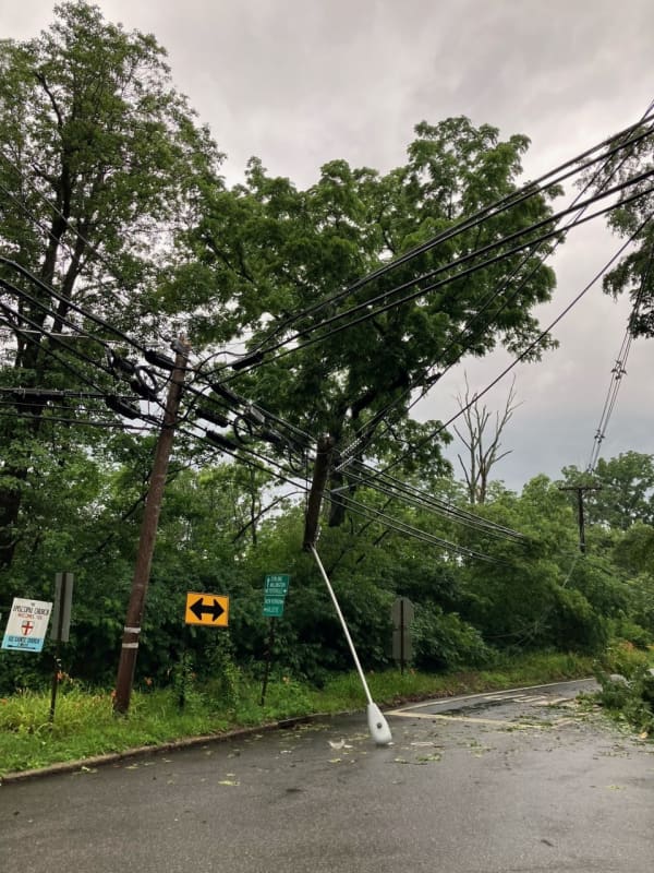
Tornado Touchdowns Confirmed In NJ, PA
A pair of tornados touched down in New Jersey and Pennsylvania during Monday, June 26's afternoon storms, the National Weather Service confirmed. Few details have been released in the twisters that touched down in Bernardsville (Somerset County, NJ) and Lower Mt. Bethel Township (Northampton County, PA). The PA tornado — rated an EF-o on the Enhanced Fujita scale — started at 2:58 p.m. and ended at 3:04 p.m., CBS reports citing the National Weather Service. The tornado reached winds of 65 mph and traveled 3.37 miles, the National Weather Service said. As of Tuesday morning, June …
Weather
Storms With Possibility Of Isolated Tornadoes To Threaten East Coast
Severe storms with the possibility of isolated tornadoes will be threatening the East Coast Monday, June 26, and will be followed by at least two more days of stormy weather, meteorologists say. Damaging winds, flash flooding, and hail are all possible by late in the afternoon Monday, forecasters are predicting. Hail could be around 1 inch in diameter, the National Weather Service said in a Hazardous Weather Outlook statement issued early Monday morning. A moderate threat was issued across North Jersey, the Poconos, and Central Pennsylvania, while a high threat was issued in South Jersey,…
Weather
Here's Cindy: New Tropical Storm Develops In Active Atlantic
It's starting to get crowded in the Atlantic basin. A brand-new tropical storm has formed just as an earlier system, Bret, continues its westward movement: Meet Cindy. As of around midday Friday, June 23, the center of Tropical Storm Cindy was about 900 miles east of the Lesser Antilles, according to the National Hurricane Center. Cindy is moving toward the west-northwest at around 16 miles per hour and this general motion is expected to continue over the next few days. Maximum sustained winds have increased to nearly 50 mph with higher gusts, the hurricane center sai…
Weather
Separate Rounds Of Thunderstorms Take Aim On Region
Bouts of rain showers and thunderstorms heading to the region are expected to make up for the abnormally-dry end of spring and start to summer. There will be scattered showers throughout the day on Thursday, June 22, which will be cooler with a high temperature in the mid-60s, according to the National Weather Service. About a quarter of an inch of precipitation is possible. Conditions will then become more stormy starting on Friday, June 23, which will be warmer and more humid with a high temperature in the mid-70s. See thunderstorms and rain being forecast along the East Coast.AccuW…
Weather
Newly-Formed Tropical System In Atlantic Expected To Become Hurricane
A new system that formed in the Atlantic basin is expected to strengthen to tropical storm status before possibly becoming the first hurricane of the 2023 season. Tropical Depression 3, which developed on Monday, June 19 in the central Atlantic, is expected to continue to move toward the west for the next several days, according to the National Hurricane Center. "The system should be approaching the Lesser Antilles late this week," said the hurricane center. "Maximum sustained winds are near 35 mph with higher gusts. Some strengthening is forecast, and the depression is forecast to be…
Weather
Tornado Touchdowns Confirmed In These NJ, PA Towns
Two small tornados touched down in New Jersey and Pennsylvania amid thunderstorms Friday, June 16, the National Weather Service confirmed, The both were EF-0 twisters: One in Pemberton (Burlington County, NJ), and the other in West Caln Township (Chester County, PA). The Pemberton tornado's trail began in Southampton Township near Burrs Mill Road south, uprooting six trees as it traveld 3.4 miles to Ongs Hat Road, Stockton Bridge Road, and across Magnolia Road, at 12:55 p.m. in Pemberton, the NWS said. Confirmed tornado in Pemberton Township Burlington County, NJ. The image shows the p…
Weather
These Maps Show Realtime Smoke, Air Quality As Canadian Wildfires Rage
Can't tell if it's smoke or cloudy skies above? The following realtime configurations and air quality maps won't have you guessing anymore. A realtime configuration from Fire Smoke Canada — the Canadian portal for information about wildland fire weather and smoke — shows exactly where each of the more than 150 wildfires are raging and predicts roughly how heavy the smoke will be and where. The New York Times, meanwhile, has a similar smoke forecast map that indicates light, medium, or high levels of smoke from the fires, based on the National Oceanic and Atmospheric Administration. The rea…
Weather
Smoky Summer: Could Week Of Wildfires Be Preview Of What's Ahead?
Are this week's smoky skies a preview of Summer 2023 in the Northeast? According to U.S. National Weather Service meteorologist Bryan Ramsey, that depends. Ramsey is quoted by CBS New York saying "it's really just going be all about the wind shift." According to AccuWeather Senior Meteorologist Brett Anderson, the Canadian wildfires are showing no signs of slowing down and will "likely continue to burn over Quebec into the summer, as they are in remote, heavily wooded areas," he said. But, if what Ramsey is saying is true, then raging fires in Canada — and locally, for that matter — …
Weather
Here's How To Check Conditions In Your Area As Canadian Wildfires Burn
Widespread smoke from Canadian wildfires continue to bring hazardous air quality levels across the region. Air quality levels in outdoor air are predicted to be greater than an Air Quality Index value of 100 for the pollutant of fine particulates again on Thursday, June 8, according to the National Weather Service. Check air quality conditions in your area, visit AirNow.gov by clicking here. "The higher the AQI value, the greater the health concern," said the weather service. ALSO SEE: Smoke Relief Coming Next Week, Unhealthy Air Quality Here To Stay (Mostl…
Weather
Smoke Relief Coming Next Week, Unhealthy Air Quality Here To Stay (Mostly) Until Then
Looks like the East Coast has a smoky few days in store. But fear not, relief is allegedly on the way. As of Thursday, June 8, levels in North Jersey were considered very unhealthy and in greater Philadelphia/the Lehigh Valley were considered hazardous. Levels in the Baltimore and Washington DC area were also considered very unhealthy as of Thursday morning. ALSO SEE: Here's How To Check Conditions In Your Area As Canadian Wildfires Burn Canadian wildfire smoke expends south Thursday and Friday.AccuWeather Smoke improvement forecast from AccuWeather.AccuWeather Areas around New Yor…
1
2
3
4
5
6
7
8
9
10
Archive