Find Your Daily Voice
Cresskill-Closter
Demarest
Your Local News for Cresskill, Closter, and Demarest
Saturday, apr 27
45°
Follow
News
Schools
Business
Obituaries
Police & Fire
Weather
Lifestyle
Politics
Sports
Events
Real Estate
Tags
Jobs
Shop
Support Us
Cresskill-Closter
Demarest
Follow
Find Your Daily Voice
News
Schools
Business
Obituaries
Police & Fire
Weather
Lifestyle
Politics
Sports
Events
Real Estate
Tags
Jobs
Shop
Support Us
Home
About us
All sites
Advertise with us
Contact us
Terms of use
Privacy policy
Code of ethics
Site Map
© 2024 Cantata Media
45°
Saturday, apr 27
Tag:
Nor'easter
Weather
Airlines Waive Some Fees As Flight Delays, Cancellations Climb At Newark Airport
Multiple airlines are waiving travel fees for flight changes as a powerful Nor'Easter moves through the region. Newark Airport experienced 124 flight delays and 129 cancellations as of noon on Tuesday, March 14, according to FlightAware. The highest number of flight delays at Newark Airport were for United Airlines, with a total of 56 in the last 24 hours, while Republic reported 53 cancellations and 22 delays. The following airlines are allowing passengers to change their flights at no additional cost: American Airlines Delta Spirit Southwest United A wintry mix of precipita…
Weather
It's Time To 'Spring Forward,' But Storm Packed With Strong Winds Is Coming
We're just hours away from the start of Daylight saving time with clocks moving ahead one hour at 2 a.m. Sunday, March 12. Though it's "Spring Forward" time, a potent storm that will be packed with a mix of snow, sleet, rain, and strong winds that could cause power outages is headed to the region. The time frame for the storm is Monday, March 13 into Tuesday, March 14, according to the National Weather Service. A look at projected snowfall totals from the early week Nor'easter.AccuWeather.com It will be the second winter storm in the span of days as the weekend is off to a messy storm…
Weather
Post-Easter Nor'easter? Brace For Freezing Temps, Wintry Mix
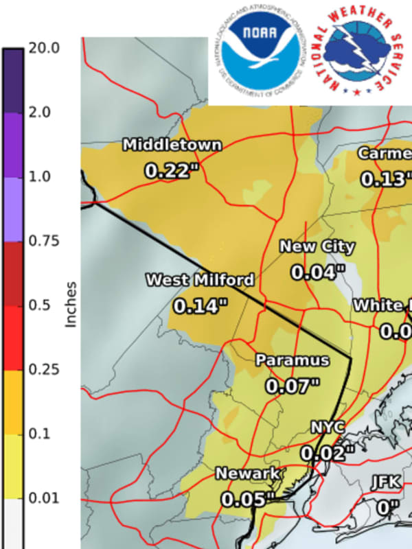
A post-Easter Nor'easter could dump snow on parts of the region this week as winter clings on for dear life, AccuWeather meteorologists say. The projected time frame for the storm is from early Monday evening, April 18 until around midday on Tuesday, April 19. Rain and thunderstorms were likely in New Jersey, Maryland and the Philadelphia region, save for a wintry mix including snow in much of Central PA, forecasters say. Easter Sunday, April 17 will be mostly sunny and brisk with a high temperature only in the upper 40s, according to the National Weather Service. Freeze watche…
Obituaries
New York Kayaker Mourned After Death During Nor'easter
Memorial services have been scheduled to honor the life of a Westchester County man who died after a powerful Nor'easter rolled in while he was kayaking on the Long Island Sound. Laurence Broderick, age 45, of Scarsdale, was reported overdue by his family on Tuesday, Oct. 26, after he left Hempstead en route to Mamamronek in his kayak at about 9 p.m. on Monday, Oct. 25, authorities reported. He was found unresponsive by the US Coast Guard on Tuesday afternoon, and he was taken to the hospital where he was pronounced dead. A visitation will be held from 2 p.m. to 9 p.m. on Monday, Nov…
News
NJ Schools Closed, Delayed Due To Nor'easter
Several New Jersey school districts were closed or had delayed openings on Tuesday due to the Nor'easter. Between 1 and 4 inches of rain were possible during the storm across the Garden State. The following districts were closed: Bayonne Public Schools Butler Public Schools Hazlet Township Public Schools Jersey City School District Montclair Orange Public Schools Paterson Public Schools The following districts had delayed openings: Harrison School District Madison Public Schools Mendham Boro Milltown School District Piscataway School District Riverdale Boro South Brunswick Union D…
Weather
Storm Scenarios: Will Potential Super Bowl Sunday Nor'easter Move Up Coast Or Farther Inland?
Two major blockbuster Nor'easters in the span of a week? It could happen. Another potentially major storm is taking aim on the region, this one on Super Bowl Sunday, Feb. 7 into Monday, Feb. 8. American models now predict the storm track will be farther north and inland than the Nor'easter earlier this week. (See image 1 above.) European forecast models have the storm following a similar track to this week's Nor'easter. (See image 2 above.) "One particularly important piece will be a weak storm moving through the Ohio Valley and Great Lakes ahead of the big storm," AccuWe…
News
Nasty Nor'easter (
Update
): Expect Blizzard-Like Effects On Travel, Power
UPDATE: It's not snowfall totals of more than a foot and a half in some New Jersey counties and parts of Pennsylvania that have forecasters concerned about the nasty nor'easter heading our way: It's the blizzard-like conditions. That means travel will be “very difficult to impossible” beginning with the arrival of the prolonged storm around 7 p.m. Sunday and continuing through 1 p.m. Tuesday, the National Weather Service said Sunday morning. There will also be power outages from downed trees and snagged wires, as well as flooding in coastal areas. Morris, Sussex and Warren counties are ex…
Weather
Nor'easter: Sleet, Freezing Rain Combo – Not Snow – Will Be The Problem In North Jersey
A combination of sleet and freezing rain could cause serious trouble when a hit-and-run Nor'easter clips North Jersey on Thursday, the area's local weather expert says. Rush-hour driving will get treacherous in some areas late Thursday afternoon into the evening, said meteorologist Joe Cioffi. So motorists need to stay alert and build in extra time getting to their destinations, he said. “This is especially true since the last time anyone drove in winter precipitation was back in March,” Cioffi said. “So everyone will likely be a bit rusty.” Be sure to have your ice scraper handy – and dr…
Weather
Eye Of The Storm: Quick-Moving Nor'easter Roars Through Area
The first Nor'easter of the season has arrived Saturday morning, bringing heavy rain and gusty winds across the area as the precipitation spreads north ahead of strong low pressure. A half-inch of rain had already fallen by 8 a.m. Up to 2 inches is possible before the quick-moving storm moves east late Saturday afternoon. Winds may gust to near 50 mph may bring down tree limbs and cause power outages. It will be chilly and rainy throughout the day. While the high temperature will climb to around 50 degrees, the gusty winds will make it feel like it's in the low-40s. In some spots farthes…
Weather
Eye On The Storm: Here's What To Expect And When Nor'easter Roars Through Area
Click here for an updated story: Eye Of The Storm: Quick-Moving Nor'easter Roars Through Area The Nor'easter that will roar through the region overnight Friday through Saturday will be accompanied by heavy rain that could cause flooding and strong winds gusts that could lead to power outages. Rain will be heavy at times on Saturday, accompanied winds of 15-25 mph with gusts of 40 and higher, along with a storm surge capable of causing coastal flooding with the high tide cycle late Saturday morning into early Saturday afternoon. "The winds may be strong for a few hours, to break tree…
Weather
Latest Update On Timing, Strength Of Nor'easter Barreling Toward The Area
Click here for an updated story: Eye On The Storm: Here's What To Expect And When Nor'easter Roars Through Area As Hurricane turned Tropical Depression Willa dumps rain on the south while barreling north, more details on the timing and strength of the Nor'easter that will hit the area this weekend are emerging. On Friday, Mid-Atlantic states will see Gale-force winds at the coast of between 40-45 mph that could cause power outages and widespread heavy rain with flooding possible. The storm will rapidly make its way up the coast before arriving in the tristate area around midnight. Rain wi…
Weather
How Much Snow Did You Get? A Look At Totals From The Area
The first full day of spring brought the fourth Nor'easter of the month. Perhaps fittingly, in what has been an unpredictable stretch of weather, the complex storm arrived later than expected on Wednesday, and affected different parts of the area at different times. That's reflected in snowfall totals. Here now is a sampling. If you don't see your town's total listed, be sure to leave it by posting a comment here. Westchester County Armonk 5.4 inches, 10 p.m. Wednesday Croton-On-Hudson 2.7 inches, 10:45 p.m. Wednesday Harrison 9.5 inches, 11 p.m. Wednesday Somers 2.3 inches, 11:25 p.…
Schools
Morning Update: Bergen County Schools Announce Wednesday Closings
Projected Snowfall Totals Increase As Fourth Nor'easter Nears The following area school districts and schools have announced they will be closed on Wednesday, March 21 as a result of the latest Nor'easter. Some districts that first announced early dismissals are now closed (Haworth, Little Ferry, Garfield, Closter). REFRESH LINK FOR UPDATES Ben Porat Yosef Bergenfield Bogota Carlstadt Clifton Closter Cresskill Dumont East Rutherford Edgewater Elmwood Park Emerson Englewood Englewood Cliffs Fair Lawn Fairview Fort Lee Franklin Lakes Garfield Glen Rock Hackensack Hasbrouck Heights Haworth …
Weather
Latest Projected Snowfall Totals For Fourth Nor'easter
The first full day of spring will bring as much as a foot or more of snow to the tristate area as the fourth Nor'easter of the month moves through the region on Wednesday. The latest snowfall projections, by the National Weather Service and AccuWeather.com, can be viewed in the first two images above. Snow is expected to begin sometime Wednesday morning and continue throughout the day, becoming heavy at times Wednesday afternoon and evening with snowfall rates of 1 to 3 inches per hour are possible for the afternoon and evening, said the National Weather Service. Visibility will be one-quar…
Weather
Projected Snowfall Totals Increase As Fourth Nor'easter Nears
Following what was a relentless winter, in a cruel twist, the first full day of spring will bring as much as a foot or more of snow to the tristate area as the fourth Nor'easter of the month moves through the region on Wednesday. The latest snowfall projections, issued late Tuesday afternoon by the National Weather Service, can be viewed in the first image above. Snow is expected to begin sometime Wednesday morning and continue throughout the day, becoming heavy at times Wednesday afternoon and evening with snowfall rates of 1 to 3 inches per hour are possible for the afternoon and evening,…
Weather
New Nor'easter's Heavy Snow, Strong Winds Could Cause Power Outages
Click here for an updated story: Projected Snowfall Totals Increase As New Nor'easter Nears While some uncertainty still remains about the potential amount of snowfall from the fourth Nor'easter to hit the region this month, the heavy, wet snow, combined with strong winds, could lead to new power outages and tree damage. Winds will gust 30 to 35 mph along the coast during the height of the storm on Wednesday, 25 to 30 mph inland and 25 mph or less farther north. (See second image above.) Coastal flooding and beach erosion are also likely. Still, this will not be a powerhouse storm in terms…
Weather
Possible Fourth Nor'easter Could Last For Days
Click here for an updated story: New Forecast Models Released For Start-Of-Spring Storm A fourth possible Nor'easter to hit the area this month could bring a combination of rain, snow and strong winds to a storm-weary region over a period of three days next week, according to the latest models. The updated possible time frame for the start-of-spring storm is now Tuesday afternoon through early Thursday morning. It’s still too early to project how much rain and snow the storm may bring, or what parts of the area would see rain, snow, or a wintry mix. The first three Nor'easters, from Marc…
Weather
Nor'easter No. 4? Latest Storm Brewing Could Arrive As Spring Starts
Click here for an updated story: Start Of Spring Storm Now Likely, With Potential For Snow, Strong Winds Not even the start of spring may be able to prevent a fourth possible Nor'easter from affecting the area next week. While we will not have a better idea as to the severity of the storm for several days, the system is expected to track over the Central states before turning eastward early next week, according to AccuWeather.com. Parts of the mid-Atlantic, or New England, or both areas, may face yet another Nor'easter with gusty winds, snow inland and rain or snow at the coast, AccuWeat…
Weather
Eye On The Storm: New Snowfall Projections As Nor'easter Nears
Click here for an updated story: Nor'easter Brings Heavy Snow, Wind As the third Nor'easter in two weeks moves into the area overnight, new snowfall projections were released by the National Weather Service late Monday afternoon. Most of the tristate area is expected to see 3-4 inches of accumulation, with a range of 4 to 6 inches in the eastern sections of Westchester, Putnam and Dutchess and all of Fairfield County. (See images above.) A Winter Storm Warning is in effect for Fairfield County from 8 p.m. Monday until 6 p.m. Tuesday. A Winter Weather Advisory has been issued for the entire…
Weather
Latest Snowfall Projections Show Higher Amounts For Parts Of Area
Click here for an updated story: Winter Weather Advisory: Latest Info On New Nor'easter The latest snowfall projections for the third Nor'easter that will hit the area in a 12-day span once again show a range of 3 to 6 inches of accumulation for most of the tristate, but areas in Fairfield County along the coast could now see up to 8 inches, according to the National Weather Service. (See image above.) In addition, farther west and north, Orange County went from 3-4 projected inches Sunday morning to 4-6 in the new projections released late Sunday afternoon. Clouds will increase on Monda…
News
Powerless: Parts Of Bergen County Remain In The Dark
Four days after the latest Nor'easter, thousands of North Jersey residents remain without power. PSE&G on Sunday it is still working to restore power to 3,950 of its customers -- several hundred in Bergen and Passaic counties. Here are the areas that remain without power as of Sunday afternoon: Cliffside Park: 1,000 customers Englewood Cliffs: 540 customers Hawthorne/Haledon: 100 (approximate) A handful of customers in Woodcliff Lake, Montvale, Bergenfield and Garfield/Lodi. Less than 100 JCP&L customers are without power in Wayne. Most of the company's customers who lost power…
Weather
Time Frame Changes For Third Possible Nor'easter
Click here for an updated story: Snowfall Projections Released For Early Week Storm There is still much uncertainty surrounding the path of a possible Nor'easter that could affect the area early in the workweek, but the time frame for the storm has changed. The storm, if it pans out, would arrive later than originally predicted, with possible impact now Monday night into Tuesday morning for a region that already has been battered by two other Nor'easters this month. According to the latest forecast from the National Weather Service, there is now a 40-percent chance of snow Monday night i…
Weather
Winter Storm Watch: Midweek Nor'easter Could Bring 6-12 Inches Of Snow
Click here for an updated story: New Storm Snowfall Projections Increase Accumulation Range To 10-12 Inches A new winter storm now in the Upper Midwest is expected to develop into another Nor'easter bringing up to a half-foot or more of snow to the area in the middle of the workweek. The storm is moving across the country, producing blizzard conditions in the northern Plains and snow in the Midwest before becoming a coastal storm in the Northeast on Wednesday that could result in 3 to 6 inches or more of snow for much of the tristate area, according to the National Weather Service. Areas …
Weather
Snow Way: New Nor'easter Could Slam Area With Up To Half-Foot
Click here for an updated story: Midweek Storm Could Bring 6-12 Inches Of Snowfall To Area A new winter storm brewing in the Upper Midwest could develop into another Nor'easter bringing up to a half-foot or more of snow to the area in the middle of the workweek. The storm will move across the country, producing blizzard conditions in the northern Plains early in this week before bringing snow in the Midwest and then possibly becoming a coastal storm in the Northeast on Wednesday that could result in 3 to 6 inches or more of snow for much of the tristate area, according to the National We…
Police & Fire
Hawthorne Man Killed, Passenger From Paterson Hurt When Tree Falls On Car
A 25-year-old motorist from New Jersey was killed Friday afternoon when a large tree fell on his car on the Merritt Parkway in Fairfield County amid the damaging Nor'easter. Jonathan Rodriguez-Melendez of Hawthorne was traveling southbound near the Stamford-Greenwich border south of Exit 33 at about 1:20 p.m. amid rain and severe crosswinds when the tree fell on his Mini Cooper, Connecticut State Police said. Rodriguez-Melendez was pronounced dead at the scene. Francisco Berdecia, 33, of Paterson, New Jersey, a passenger in the vehicle, was transported to Greenwich Hospital with minor, non-…
Weather
Not Over Yet: Treacherous Travel With Downed Trees, Slick Roads In Area
It's not over yet. The Nor'easter tearing through the area has left thousands without power, hundreds of downed trees and power lines and numerous road closures, resulting in treacherous travel that will continue through Saturday morning. In the Hudson Valley, an 11-year-old boy was killed Friday afternoon when a tree crashed through a home amid the storm in Putnam County. One town in the area, Greenburgh, had 13 downed tree incidents as of late Friday afternoon. A total of 70,000 were left without power early Friday afternoon in Dutchess County, making it what a Central Hudson spokesman …
Weather
Eye Of The Storm: Morning Update As Dangerous Nor'easter Arrives
Taconic Closure, I-684 Crash Among Numerous Incidents On Slick Roadways Projected Snowfall Totals Increase A dangerous Nor'easter will hit the tristate area from Thursday night into Saturday morning, bringing with it something of everything: Snow, heavy rain, damaging winds that could cause power outages and possible flooding. Here's a look at the timeline of the storm: Friday morning: Rain will mix with snow and be all snow at times farther north. Temperatures will fall during the day Friday into the low 30s during the afternoon, with winds between 25 and 30 miles per hour, gusting to as…
Weather
Eye On The Storm: A Look At Timing For Dangerous Nor'easter
Click here for an updated story: Projected Snowfall Totals Increase As Fierce Nor'easter Nears A dangerous Nor'easter will hit the tristate area from Thursday night into Saturday morning, bringing with it some snow, heavy rain, damaging winds that could cause power outages and possible flooding. Here's a look at the timeline of the storm: Thursday evening: Rain arrives, mainly after 7 p.m. with up to an inch of accumulation possible overnight Friday morning: Rain will mix with snow and be all snow at times farther north. Temperatures will fall during the day Friday into the low 30s during…
Weather
New Storm Will Be Strongest Nor'easter Since January 'Bomb Cyclone'
Click here for an updated story: Flood Watch Issued As Nor'easter Nears Area Get set for the strongest storm since the "Bomb Cyclone" from early January as the area could see Nor'easter-type conditions on Friday. While this storm will fall short of the Bomb Cyclone's intensity and will not be as cold, it will still pack a wallop, according to AccuWeather.com. Wind gusts of 50 miles per hour or more are possible along the coast Friday night with beach erosion and coastal flooding possible. Light rain will arrive late in the afternoon Thursday and continue overnight into Friday …
Weather
Nor'easter Approaching Area Reaches 'Bomb Cyclone' Status
While the East Coast gears up for the rapidly approaching Nor'easter that’s expected to pummel the area overnight, locals can also expect to experience another weather phenomenon known as a “bomb cyclone.” The National Weather Service has predicted that the region may see anywhere from 2 to 4 inches of snow, with the storm expected to hit the area beginning around 1 a.m. on Thursday morning. According to the National Ocean and Atmospheric Administration, “bombogenesis, a popular term used by meteorologists, occurs when a mid-latitude cyclone rapidly intensifies, dropping at least 24 milliba…