Find Your Daily Voice
 48°
48°
'Get Ready For A Winter Wonderland': Old Farmer's Almanac Releases 2023-24 Forecast
The mild winter of 2022-23 may become a distant memory with more typical conditions expected in 2023-24, according to the Old Farmer's Almanac.
"The 2024 Old Farmer’s Almanac predicts snow, seasonable cold, and all of winter’s delights," states the publication, which has been making long-term weather forecasts since 1792.
"This winter’s forecast is sure to excite snow bunnies and sweater lovers alike, promising a whole lot of cold and snow across North America."
In the Northeast, snow will arrive beginning in November, with storms, showers, and flurries continuing through …
Here's Your Best Chance To Catch Upcoming Perseid Meteor Shower
The highly-anticipated Perseid meteor shower will return with a stunning sky show for viewers around the world.
Considered the most scenic meteor shower of the year, viewers can enjoy spectacular sights each July and August.
The shower became active on July 17, and the number of meteors increase every night until the shower's peak, on Saturday, Aug. 12, and Sunday, Aug. 13, according to Royal Museums Greenwich (RMG).
The best time to step outside for a sky-gaze? Head out in the early-morning hours, before sunset, the week before or after the August peak.
According to RMG, the m…
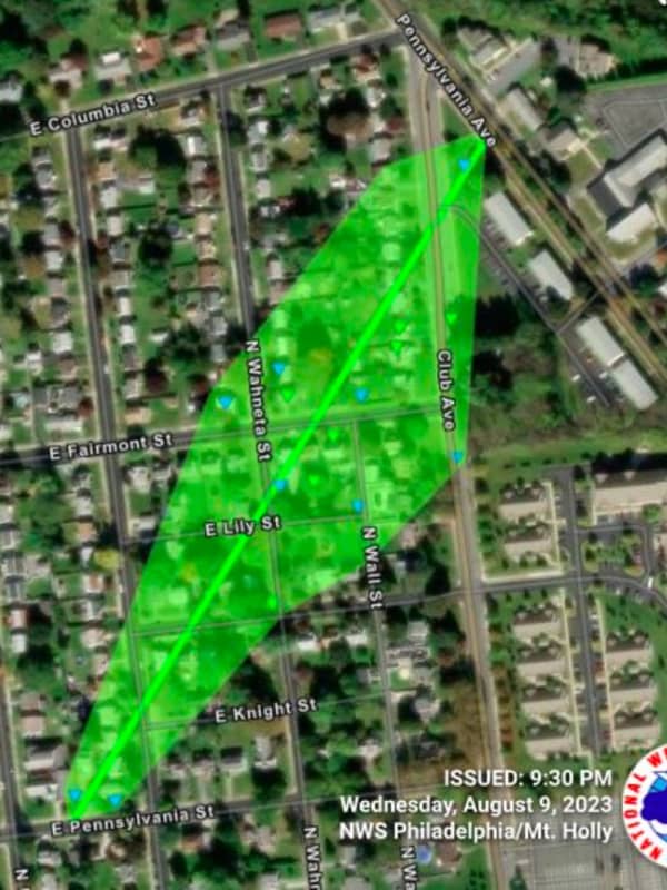
Severe Thunderstorm, Tornado Watch In Effect For South Jersey
Strong to severe thunderstorms will move through the area Monday afternoon, Aug. 7 and Monday evening, according to the National Weather Service.
The storms will bring the potential for damaging wind gusts, a few tornadoes, and localized flash flooding, the NWS said.
The tornado watch includes Mercer, Atlantic, Burlington, Camden, Cape May, Cumberland, Gloucester and Salem counties, the NWS said.
A slighter chance of thunderstorms exists along the Jersey Shore.