Tag:

Severe Thunderstorms

Tornado Hit Region During Round Of Storms, National Weather Service Says Tornado Hit Region During Round Of Storms, National Weather Service Says
Tornado Hit Region During Round Of Storms, National Weather Service Says New Update - Tornado: Detailed Info Released On Strong Twister With 115 MPH Winds That Hit Sullivan County A tornado touched down in New York during a round of severe thunderstorms Saturday night, April 22, the National Weather Service said. The twister tore through an area in the Catskills, in northwestern Sullivan County, at around nightfall Saturday from Roscoe to Calicoon Center, damaging several buildings. Specific information about the tornado, including its exact path, length, and intensity has not yet been released. Traffic Alert: Wires and trees are down in the Roscoe and Cal…
Storm Watch: System With Damaging Winds Could Include Hail, Isolated Tornadoes Storm Watch: System With Damaging Winds Could Include Hail, Isolated Tornadoes
Storm Watch: System With Damaging Winds Could Include Hail, Isolated Tornadoes The month of April will get off to a stormy start with steady rainfall at times followed by severe thunderstorms with damaging winds that could cause power outages. The system arrived in the pre-dawn hours on Saturday, April 1 with rain and showers. Storm activity is expected to pick up in the afternoon through the evening. For a look at the wide area where severe storms are possible, see the first image above from AccuWeather.com. "The primary threat is from damaging wind gusts, but hail and an isolated, brief tornado are also possible," the National Weather Service said in…
Scattered Strong To Severe Thunderstorms Will Sweep Through Region Scattered Strong To Severe Thunderstorms Will Sweep Through Region
Scattered Strong To Severe Thunderstorms Will Sweep Through Region A new round of scattered strong to severe thunderstorms is on track for the region. The system will arrive following a sunny and hot day on Thursday, Aug. 25 with a high temperature around 90 degrees. The storm chance will start in the morning on Friday, Aug. 26, but showers and thunderstorms are expected mainly during the afternoon into the evening, the National Weather Service said.  Some storms could produce drenching downpours and gusty winds.  The high temperature Friday will be in the upper 80s. The chance for storms and showers from the system will last into the early mo…
New Round Of Strong Storms With Gusty Winds, Possible Hail Will Sweep Through Region New Round Of Strong Storms With Gusty Winds, Possible Hail Will Sweep Through Region
New Round Of Strong Storms With Gusty Winds, Possible Hail Will Sweep Through Region It's not over yet. Following scattered severe thunderstorms overnight, a new round of showers and storms is expected to develop on Saturday, May 28. The expected time frame for storm activity from around midday into early Saturday evening. A slow moving cold front will trigger storm activity, the National Weather Service in a Hazardous Weather Outlook statement issued early Saturday morning. Isolated flash flooding is possible. "Some storms could produce strong gusty winds, small hail, and locally heavy rain," the weather service said. Saturday won't be a complete washout though, but sk…
Line Of Severe Storms Will Bring Downpours, Strong Winds, Possible Isolated Tornadoes Line Of Severe Storms Will Bring Downpours, Strong Winds, Possible Isolated Tornadoes
Line Of Severe Storms Will Bring Downpours, Strong Winds, Possible Isolated Tornadoes Potentially severe thunderstorms with strong wind gusts will sweep through the region on the final day of the winter season on Saturday, March 19. "The threat will stem from an area of low pressure and its associated cold front that will march eastward through the Ohio Valley and Northeast through the day Saturday and into the evening hours Saturday night," said AccuWeather Meteorologist Brandon Buckingham. For a look at areas most at risk for torrential downpours, damaging wind gusts, and possible isolated tornadoes, see the first image above. The entire region will see showers …
Line Of Strong Storms With Damaging Winds Sweeping Through Region: Here's Latest Line Of Strong Storms With Damaging Winds Sweeping Through Region: Here's Latest
Line Of Strong Storms With Damaging Winds Sweeping Through Region: Here's Latest A line of severe thunderstorms with damaging wind gusts that could cause power outages is moving from west to east as a strong cold front sweeps through the region. A Wind Advisory that went into effect Monday, March 7 at 6 p.m. lasts through 4 a.m. Tuesday, March 8, the National Weather Service announced. Gusts of up to 50 miles per hour are possible during that time. "Gusty winds could blow around unsecured objects," the weather service said. "Tree limbs could be blown down and a few power outages may result." Earlier report  - Weather Whiplash: Storms With Strong Wind Gusts …
New Round Of Severe Storms With Damaging Wind Gusts Possible New Round Of Severe Storms With Damaging Wind Gusts Possible
New Round Of Severe Storms With Damaging Wind Gusts Possible There's a chance for a new round of potentially severe thunderstorms to sweep through the region. The time frame in which storm activity is possible is from the early afternoon on Wednesday, July 14 until close to midnight. There will be scattered showers and drizzle at times in the morning on Wednesday, which will be a warmer and more humid day, with the high temperature in the mid 80s. There will be some sunshine in the afternoon before a line of showers and storms is expected to sweep through the region from the west to the east. Some of the storms could have damaging wind gu…
Tornado Warning Issued For Parts Of Region Tornado Warning Issued For Parts Of Region
Tornado Warning Issued For Parts Of Region The National Weather Service has issued a Tornado Warning for parts of the region. The warning, issued at 6:15 p.m. Monday, July 12 by the National Weather Service, covers two New York counties near the New Jersey border: Southcentral Orange County  Rockland County The warning is in effect until 7 p.m. Monday. Severe thunderstorms and isolated tornadoes are possible Monday night throughout the area. A severe thunderstorm capable of producing a tornado in Bloomingdale, New Jersey, was moving slowly east at 15 mph. Quarter-size hail is possible, and radar indicated rota…
New Round Of Severe Storms Sweeping Through Region New Round Of Severe Storms Sweeping Through Region
New Round Of Severe Storms Sweeping Through Region 
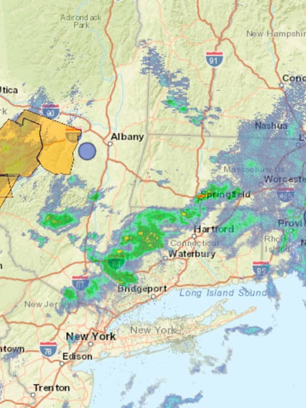
For the third straight day, a line of severe thunderstorms is moving through the region from west to east. Scattered storm activity is expected Thursday afternoon, July 8, and into the evening. At 12:45 p.m., storms with heavy rain have arrived in New York, north of I-84 in Orange, Ulster, and Dutchess counties. Storm activity could become more widespread later. Damaging winds gusts of around 60 miles per hour are the main threat, the National Weather Service said. Related story: Here Comes Elsa: Tropical Storm Will Bring Heavy Rain, Gusty Winds To Region In addition, localized heav…
Strong To Severe Storms With Damaging Wind Gusts Possible In Region Strong To Severe Storms With Damaging Wind Gusts Possible In Region
Strong To Severe Storms With Damaging Wind Gusts Possible In Region A surge in temperatures will be accompanied by a system that could bring strong to severe thunderstorms with gusty winds to the region. The time frame for storm activity is late Tuesday afternoon to late Tuesday evening, July 6. The primary threat from the potential storms is damaging winds, the National Weather Service said in a Hazardous Weather Outlook statement issued early Tuesday. A Heat Advisory is in effect for the entire region starting around midday Tuesday and lasting until Wednesday evening, July 7. There will be a mix of sun and clouds during the day with a high temp…
Severe Weather Alert: Storms With Damaging Winds, Heavy Rain, Possible Hail Will Sweep Through Severe Weather Alert: Storms With Damaging Winds, Heavy Rain, Possible Hail Will Sweep Through
Severe Weather Alert: Storms With Damaging Winds, Heavy Rain, Possible Hail Will Sweep Through Scattered, severe thunderstorms will bring heavy rain and strong winds with gusts up to 60 miles per hour to the region. The window for storm activity will be from about 2 p.m. until 8 p.m. Tuesday, Aug. 25. Hail is also possible, the National Weather Service said in a Hazardous Weather Statement issued Tuesday morning. Tuesday will be another hot day with temperatures climbing into the upper 80s and lower 90s.  After a mostly sunny start, clouds will increase before the afternoon arrival of a cold front, triggering the storms. Following the passage of the cold front,…
Tornado Watch Issued, With 70 MPH Wind Gusts, Large Hail Also Possible Tornado Watch Issued, With 70 MPH Wind Gusts, Large Hail Also Possible
Tornado Watch Issued, With 70 MPH Wind Gusts, Large Hail Also Possible A Tornado Watch has just been issued for much of the region. It's in effect until 10 p.m. Sunday, Aug. 2.  Main threats include the potential for tornadoes, scattered damaging wind gusts up to 70 mph, and isolated large hail. Scattered severe thunderstorms are also expected through around 11 p.m. Sunday. The watch does not currently include New York City or Long Island. For a look at areas covered by the watch, see the first image above. Earlier report: Severe Thunderstorms With Damaging Winds, Possible Tornadoes Expected Ahead Of Isaias' Arrival
Severe Thunderstorms With Damaging Winds, Possible Tornadoes Expected Ahead Of Isaias' Arrival Severe Thunderstorms With Damaging Winds, Possible Tornadoes Expected Ahead Of Isaias' Arrival
Severe Thunderstorms With Damaging Winds, Possible Tornadoes Expected Ahead Of Isaias' Arrival Scattered severe thunderstorms with heavy rain, strong winds and hail are expected, with isolated tornadoes possible, ahead of the anticipated arrival of Hurricane turned Tropical Storm Isaias.  Showers and storms are possible starting Sunday morning, Aug. 2. The likelihood of storms increases Sunday afternoon and evening. The highest chance for storms will be north and west of New York City from about 2 p.m. until 11 p.m. Sunday. Damaging winds, heavy rain and large hail are the main threats, however, an isolated tornado cannot be ruled out, the National Weather Service said in …
Severe Weather Alert: Scattered Storms With Drenching Rain, Gusty Winds Will Sweep Through Area Severe Weather Alert: Scattered Storms With Drenching Rain, Gusty Winds Will Sweep Through Area
Severe Weather Alert: Scattered Storms With Drenching Rain, Gusty Winds Will Sweep Through Area A round of scattered, severe thunderstorms will sweep through the region on another day of hazy, hot and humid conditions. The time frame for storm activity on Tuesday, July 28 is from about 2 p.m. until about 9 p.m. Damaging winds are the main threat, the National Weather Service said in a Hazardous Weather Outlook statement issued early Tuesday morning.  The storms will be capable of producing locally heavy downpours which could lead to urban flooding of low lying and poor drainage areas, the weather service noted. Areas in darker green shown in the two images above have a higher r…
Here's When New Round Of Thunderstorms With Damaging Wind Gusts Are Possible Here's When New Round Of Thunderstorms With Damaging Wind Gusts Are Possible
Here's When New Round Of Thunderstorms With Damaging Wind Gusts Are Possible Isolated, severe thunderstorms with dangerous winds are possible throughout the region. The highest likely time frame for the storms on Monday, July 13 is in the afternoon. "Localized damaging wind gusts and flash flooding are the main threats with these storms," the National Weather Service said in a Hazardous Weather Outlook statement issued on Monday morning. Monday will be partly sunny with the high temperature in the mid 80s. Tuesday, July 14 will be mostly sunny with a high temperature in the low to mid 80s. Check back to Daily Voice for updates.
More Strong Thunderstorms Expected, With Damaging Winds, Lightning, Hail Possible More Strong Thunderstorms Expected, With Damaging Winds, Lightning, Hail Possible
More Strong Thunderstorms Expected, With Damaging Winds, Lightning, Hail Possible A brand-new round of severe thunderstorms with damaging winds is expected to sweep through the region for the second straight day. After some lingering fog on Sunday morning, June 28, the high temperature will climb into the mid 80s to around 90 in the afternoon. The most likely time frame for strong to severe thunderstorms will be from around 2 p.m. to 6 p.m. Sunday, but there is a chance for showers and storms through around 11 p.m. Sunday. Strong to damaging winds gusts will be the main threat with these storms, with a secondary threat of one-inch hail and dangerous cloud…
Severe Weather Alert: Rounds Of Strong Thunderstorms With Damaging Winds Headed To Area Severe Weather Alert: Rounds Of Strong Thunderstorms With Damaging Winds Headed To Area
Severe Weather Alert: Rounds Of Strong Thunderstorms With Damaging Winds Headed To Area There will be a big change in the weather pattern following another sunny and warm day. Friday, June 26 will be mostly sunny and a bit more humid with the high temperature in the mid 80s. Then comes the big change as a warm front approaches the area overnight. Possible strong to severe thunderstorms are possible on Saturday, June 27 both in the afternoon into the evening across the region. Heat indices of 90 to 95 degrees possible over the weekend.  The storm chance starts around 3 p.m. Saturday, which will be mostly cloudy with a high temperature in the low 80s. The window for stron…
Severe Weather Alert: Storms With Strong Winds Will Sweep Through; Hail, Tornadoes Possible Severe Weather Alert: Storms With Strong Winds Will Sweep Through; Hail, Tornadoes Possible
Severe Weather Alert: Storms With Strong Winds Will Sweep Through; Hail, Tornadoes Possible Potentially severe thunderstorms capable of producing damaging winds and small to large hail are expected to sweep through the region. An isolated tornado cannot be ruled out, the National Weather Service said. After a partly cloudy start to the day on Wednesday, June 3, showers will become likely after noontime on a day in which the high temperature will be around 80 degrees. It will be blustery with 6-10 mile-per-hour winds and gusts up to 25 miles per hour. The window for thunderstorm activity is from around 2 p.m. until 9 p.m. Wednesday, with the highest likelihood in the early evening…
Severe Weather Alert: Here Are Areas At Highest Risk For Strong Storms With Damaging Winds Severe Weather Alert: Here Are Areas At Highest Risk For Strong Storms With Damaging Winds
Severe Weather Alert: Here Are Areas At Highest Risk For Strong Storms With Damaging Winds A slow-moving cold front will bring a round of scattered severe thunderstorms with damaging winds that could cause power outages. The strongest chance for showers and storms on Friday, May 29 will be in the afternoon into the evening.  Expect multiple lines/rounds of storms, the National Weather Service said, noting that heavy downpours could cause flooding, especially in low-lying areas with poor drainage.  The strong wind gusts could bring down trees and utility poles, causing power outages. Cloud to ground lightning strikes will also accompany the storms. Areas farther north…