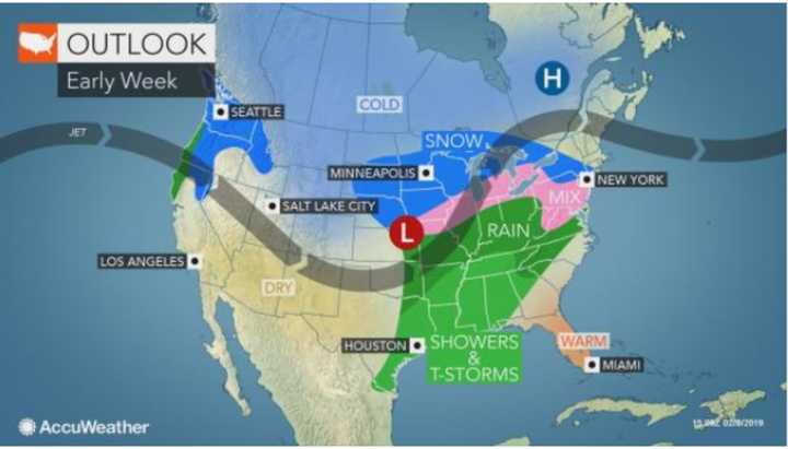
The timing has been adjusted for the winter storm that is expected to bring accumulating snow and then a wintry mix to the area early in the week
The storm is now expected to arrive earlier on Tuesday, Feb. 12 with snow now predicted for the morning after the system spreads into the area from the Midwest.
Generally, 3 to 6 inches of snowfall is expected for much of the region before a changeover to sleet south of I-287 and the Merritt Parkway at around noontime Tuesday. The changeover will occur around 3 p.m. Tuesday north of those roadways and in the early evening north of I-84 where higher accumulation amounts are expected.
According to AccuWeather.com, there is now a 41 percent chance of 3 to 6 inches of accumulation in the area, an 18 percent chance of 6 to 10 inches and 29 percent chance of between 1 and 3 inches.
In a Hazardous Weather Statement issued on Saturday morning for Tuesday for southeast New York, southern Connecticut and northeast New Jersey, saying, "A wintry mix of precipitation, which may begin as early as late Monday night, is expected Tuesday and Tuesday night. There is a chance that the combined amount of snow, sleet and freezing rain reach levels that would eventually warrant a warning."
Here's what to expect in the days leading up to the storm.
Saturday, Feb. 9: Sunny and cold with a high in the low-to-mid 30s with wind-chill values between 5 and 15 and gusts as high as 30-35 mph.
Sunday, Feb. 10: Sunny, with a high again n the low-to-mid 30s, but calmer winds.
Monday, Feb. 11: Partly sunny, with a high near 40.
Tuesday, Feb. 12: The chance for snow starts at around 1 a.m. with morning snow throughout the area before changing over to a wintry mix and sleet in the afternoon and, farther north, in the evening. The day's high temperature will be right around the freezing mark.
There is still uncertainty regarding the track and potential strength of the storm. Check back to Daily Voice for updates.
Click here to follow Daily Voice Darien and receive free news updates.

