Find Your Daily Voice
Weather
Follow
News
Schools
Business
Obituaries
Police & Fire
Weather
Neighbors
Lifestyle
Politics
Sports
Events
Traffic
Legal
Real Estate
Tags
Jobs
Shop
Support Us
Weather
Follow
Find Your Daily Voice
News
Schools
Business
Obituaries
Police & Fire
Weather
Neighbors
Lifestyle
Politics
Sports
Events
Traffic
Legal
Real Estate
Tags
Jobs
Shop
Support Us
Home
About us
All sites
Advertise with us
Contact us
Terms of use
Privacy policy
Code of ethics
Site Map
© 2024 Cantata Media
Arlington
Weather
White Christmas This Year? Here's What Meteorologists Are Projecting
If you're dreaming of a white Christmas, it might be time to snap back to reality. According to weather prediction centers and meteorologists, warmer temps are putting a damper on the chances of snow this year. Dec. 22 to 28 temperature outlook. National Weather Service The National Weather Service Climate Prediction Center is showing temps 40 to 50 percent higher than average from Dec. 22 to 28, with normal precipitation. While the Rockies and interior parts of the Northeast have a high probability of at least one inch of snow — the definition of a white Christmas — it's not looking g…
Arlington
Weather
'Deja Vu:' Another Storm With Heavy Rain, Gusty Wind Takes Aim At East Coast
Meteorologists are tracking another storm headed to the region early next week. This storm could look a lot like last weekend's storm, which brought several inches of rain, snow, and gusty winds to the region, AccuWeather says. "For millions, it will end up being a case of déjà vu," AccuWeather Senior Meteorologist Joe Lundberg said. "This next storm coming up the Eastern Seaboard will have similar characteristics to the one that slammed the mid-Atlantic and Northeast with heavy rain and wind just days ago." The rest of the week will be sunny with increasing temps, and dry. But come S…
Suffolk MA
Weather
Dreaming Of A White Christmas In Boston? It's Not Looking Good
Eastern Massachusetts residents hoping for a White Christmas likely aren't going to get their wish, according to the National Weather Service. In fact, it's going to be a warmer holiday than usual this year. Boston is already behind in its snowfall total this year with just 0.2 inches of flakes falling as of Monday, Dec. 11. For context, that's tied with Richmond, Virginia, which is not exactly known as a winter wonderland. ☃Winter Fun Fact ☃ Richmond, VA recorded 0.2" of snow today which was the first accumulating snow since March 12, 2022... Posted by US National Weather …
Montgomery MD
Weather
These Maryland, Virginia Towns Got The Most Snow During Overnight Storm
Some parts of the DMV region fared better than others as slushy snow caused several major crashes and forced schools and other government agencies to open late to provide more time for the commute. Overnight, some areas were hit with as much as six inches of snow, according to the National Weather Service, which reported the totals for each county and municipality on Monday, Dec. 11. What started as rain slowly turned to snow as temperatures dipped, though some areas were able to largely avoid Mother Nature's wrath. National Weather Service These Maryland and Virginia towns received the …
Morris
Weather
These NJ Towns Got The Most Rain, Snow In Weekend Storm
The National Weather Service has released rainfall totals from the weekend storm. Between Sunday morning, Dec. 10 and Monday morning, Dec. 11, the area that got the most amount of rain was Deerfield with 4.45 inches, then Flemington/Hopewell, with 4.29 inches. Franklin Lakes saw 4.09 inches, the NWS says. Flanders only got .13 inches, and Florham Park only had .38 inches of rain. High Point got 5.1 inches of snow, according to the NWS, the most across the state, while Wantage saw 5 inches and Hardyston saw .4 inches. Here are the average inches of rain that feel from across the s…
Union
Weather
Hundreds Without Power In These Morris, Warren, Burlington County Towns
Hundreds of New Jersey residents were left in the dark following the storm that swept through the region over the weekend. Gusty winds blew across the region Monday, Dec. 11, as hundreds waited for power to be restored. ALSO SEE: These NJ Towns Saw The Most Snow, Rain In Weekend Storm According to JCP&L, the following customers were without power as of 10:15 a.m. Monday, Dec. 11: Hunterdon County: 433 (East Amwell, 95; Lebanon, 165; High Bridge, 38). Restorations vary between 11 a.m. and 2 p.m. Morris County: 292 (Chester, 47; Harding, 55; Morris Twp., 115; Randolph, 33). Restoration…
Warren Hunterdon
Weather
Timing On Powerful Storm Dropping Up To 4 Inches Of Rain On NJ
The National Weather Service has released an event summary of the powerful storm expected Sunday, Dec. 10. Heavy rain, damaging wind, and some snow is expected in parts of New Jersey and Pennsylvania beginning with rain mid-morning Sunday, Dec. 10. ⚠️🌧️🌬️🌨️ A strong storm system will impact our region beginning today through Monday. Heavy rain, strong winds, and some... Posted by US National Weather Service Philadelphia/Mount Holly on Sunday, December 10, 2023 We are anticipating strong winds & heavy rainfall in the northern parts of the state, starting Sunday afternoon and …
Arlington
Weather
Thunderstorms, Possible Snow Heading Toward DMV
Meteorologists are cautioning that some wicked weather may be barreling towards Maryland and Virginia. While temperatures were on the rise over the weekend, the fun may be over as forecasters are calling for thunderstorms, and possibly even some snow to parts of the region. According to the National Weather Service, snow is most likely in the western parts of Maryland and Virginia, with accumulations of less than one inch expected in the majority of the area, though some extreme forecasts have called for upwards of four inches in more rural areas. Flood Watches have been expanded …
Dauphin
Weather
Snow Coming To PA In Powerful Weekend Storm (
Timing
,
Updates
)
Several inches of snow could fall across parts of Pennsylvania in a powerful storm headed to the region this weekend. While the weekend will begin with a warmup with temps expected to reach 59 come Sunday, Dec. 10, a cold front isn't far behind. By Sunday night, temps will hit a low of 33. Rain and thunderstorms that will have begun in the morning will turn to snow in the northernmost swath of Pennsylvania and greater Pittsburgh (see weather map above). "One zone that has a higher chance of picking up 6 inches of snow during Sunday night is from north and east of Scranton, Pennsylvania to …
Arlington
Weather
Screaming Winds, Pouring Rain Could Trigger Outages In Powerful Weekend Storm (
Timing
)
You can kiss the cold goodbye, but the warmer weather comes with a price. A weekend warmup will culminate in "screaming" winds and heavy rain along the East Coast come Sunday evening, Dec. 10, forecasters say. According to the National Weather Service, Friday, Dec. 8 will be sunny with a high around 50, and a low of 32. Saturday, Dec. 9 with be even warmer: 55 with patchy fog in the morning, then partly sunny. Temps will reach a high of 65 on Sunday, with rain expected to begin in the late afternoon. "Winds will be screaming a couple thousand feet up from the ground on Sunday and Sun…
Union
Weather
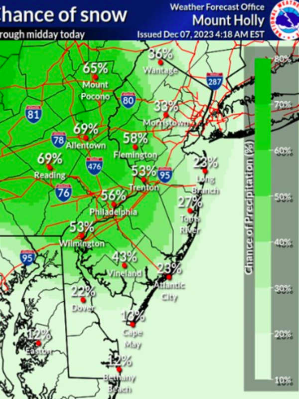
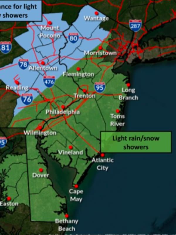
Snow Could Disrupt Travel Across New Jersey
Snow across New Jersey and Pennsylvania was expected to cause some travel disruptions Thursday, Dec. 7. Snow was already falling in the Lehigh Valley and Poconos as of 7:30 a.m., but according to the National Weather Service, flurries were headed into New Jersey. The best chance of snow was being forecast in the north and northwestern counties of New Jersey. There was a smaller chance along the Jersey Shore. Accumulations were possible but no more than an inch, the NWS said. Snowfall was expected to stop by the early afternoon. Watch for a bit of snow through midday, especially NW of …
Hackensack
Weather
Snow Flurries Fall Across North Jersey: What To Expect, Timing
Parts of New Jersey and Pennsylvania were expected to see a dusting of snow Wednesday, Dec. 6. The National Weather Service was showing wintry weather in northwest New Jersey, the Lehigh Valley, and the Poconos, with flurries already falling as of 2 p.m. We can expect to see some light snow showers and flurries throughout the day Wednesday, with the greatest chance across... Posted by US National Weather Service Philadelphia/Mount Holly on Wednesday, December 6, 2023 Parts of Bergen and Passaic counties were also expected to get light snow Wednesday afternoon, and Thursday afternoo…
1
2
3
4
5
6
7
8
9
10
Archive