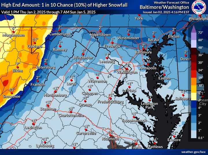
While snow lovers may be disappointed with predictions of just 1 to 2 inches for most of the area, the National Weather Service is warning that bursts of snow could create slushy roads and tricky commutes Friday afternoon and evening.
A Winter Weather Advisory is in place for parts of Frederick, Carroll, Baltimore, and Howard counties as well as other areas of central Maryland.
The storm kicks off Friday afternoon, with snow showers likely between 1 p.m. and 4 p.m. These quick bursts of snow could overwhelm warmer road temperatures and lead to slushy, slippery conditions.
- Thursday Night: Increasing clouds, with temps dipping to 28°F.
- Friday: Snow showers likely in the afternoon, possibly mixed with rain. Expect highs near 42°F, with gusts up to 20 mph. Snowfall accumulations of less than half an inch are possible for most areas.
- Friday Night: A chance of lingering snow showers before 7 p.m., then clearing skies and a frigid low of 23°F.
- Saturday: Sunny but brisk, with highs near 31°F and gusts up to 31 mph.
- Sunday: A mostly sunny morning with a high near 36°F, but snow is back in the forecast by the evening and continues into Monday.
Travel Advisory:
Drivers, take note: slippery roads are likely Friday afternoon and evening. Be prepared for reduced visibility during heavier snow showers, especially during the evening commute. Treat untreated roads with caution, as slushy accumulation is possible on bridges and overpasses.
The National Weather Service urges residents to keep travel to a minimum during the snow and to use extreme caution if driving is necessary.
Click here to follow Daily Voice Round Hill and receive free news updates.
