SHARE

Brand-New Snowfall Projections: These Areas Will See Most Accumulation

Updated snowfall projections have been released by the National Weather Service as a fast-moving Alberta Clipper system nears the region.

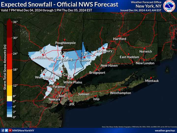
A trace to up to nearly 2 inches of snow is possible in the interior areas in the darker shades of blue. Farther south, including on Long Island, rain and freezing rain are predicted, with little or no accumulation.

A trace to up to nearly 2 inches of snow is possible in the interior areas in the darker shades of blue. Farther south, including on Long Island, rain and freezing rain are predicted, with little or no accumulation.

Photo Credit: National Weather Service

The system will sweep in from west to east starting at around 8 p.m. Wednesday, Dec.  4, with precipitation lasting until around 10 a.m. Thursday, Dec. 5.

A trace to up to nearly 2 inches of snow is possible in the interior areas in the darker shades of blue. 

Farther south, including on Long Island, rain and freezing rain are predicted, with little or no accumulation.

See the image above for the projected snowfall map.

A Wind Advisory is in effect throughout the region from 6 a.m. to 10 p.m. Thursday.

Winds will be out of the west at 20 to 30 miles per hour, with gusts up to 45 to 50 mph.

Check back to Daily Voice for updates.

to follow Daily Voice Ronkonkoma and receive free news updates.
SCROLL TO NEXT ARTICLE