SHARE

Snowfall Projections Updated For New Winter Storm Set To Hit Northeast

Snowfall projections have been updated for a new winter storm headed to the Northeast.

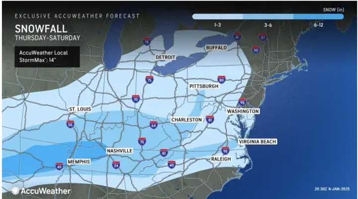
Areas in the lightest shade of blue are projected to see 1 to 3 inches of snowfall from the storm Friday, Jan. 10, into Saturday, Jan. 11. Up to 6 inches is possible in the next shade, and up to a foot in the darkest shade.

Areas in the lightest shade of blue are projected to see 1 to 3 inches of snowfall from the storm Friday, Jan. 10, into Saturday, Jan. 11. Up to 6 inches is possible in the next shade, and up to a foot in the darkest shade.

Photo Credit: AccuWeather.com
The heaviest snow and ice are predicted for the south of Washington, DC, but accumulating snow and slippery travel will range from the Midwest to southern New England.

The heaviest snow and ice are predicted for the south of Washington, DC, but accumulating snow and slippery travel will range from the Midwest to southern New England.

Photo Credit: AccuWeather

The timing for the system is Friday night, Jan. 10, into Saturday, Jan. 11, according to the National Weather Service.

The heaviest snow and ice are predicted for the south of Washington, DC, but accumulating snow and slippery travel will range from the Midwest to southern New England, where snow should be "intermittent and spotty in nature," AccuWeather says.

New Snow Accumulation Projections

See the first image above

  • Light blue areas: 1 to 3 inches
  • Next shade: up to 6 inches
  • Dark blue areas: up to a foot

"While a general 1 to perhaps 3 inches of snow is forecast, there can be pockets where a coating or a dusting of snow could be all that falls from the storm, especially along the upper mid-Atlantic coast," AccuWeather Senior Meteorologist Brett Anderson said.

Check back to Daily Voice for updates.

to follow Daily Voice Haddonfield and receive free news updates.
SCROLL TO NEXT ARTICLE