Severe Thunderstorm Watch In Effect For 10 NJ Counties, NWS Warns Severe Thunderstorm Watch In Effect For 10 NJ Counties, NWS Warns
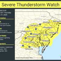
Severe Thunderstorm Watch In Effect For 10 NJ Counties, NWS Warns A Severe Thunderstorm Watch is in effect for 10 New Jersey counties through 7 p.m. Wednesday, June 18, as damaging storms threaten to slam the region with hail, wind, and lightning, according to the National Weather Service. The counties under watch include: Atlantic, Burlington, Camden, Cape May, Cumberland, Gloucester, Mercer, Monmouth, Ocean, and Salem. The Storm Prediction Center says conditions are right for frequent lightning, heavy downpours, and wind gusts strong enough to cause property damage and power outages. Meanwhile, residents in northeast New Jersey—including Passaic, Berg…
Heat Advisory Issued In NJ/PA: Here’s Where Temps Will Feel Like 100° Heat Advisory Issued In NJ/PA: Here’s Where Temps Will Feel Like 100°
Heat Advisory Issued In NJ/PA: Here’s Where Temps Will Feel Like 100° The National Weather Service has issued a Heat Advisory for parts of New Jersey and Pennsylvania, with “heat index values up to 99 expected” and the potential for it to feel even hotter in the sun. The advisory is in effect from 11 a.m. Wednesday, June 18, through 8 p.m. Thursday, June 19, as dangerously high temperatures and humidity grip the region. ⚠️ Heat Advisory Areas Include: Camden County Gloucester County Northwestern Burlington County Philadelphia County Delaware County “Hot temperatures and high humidity may cause heat illnesses,” officials said in the advisory issued at 2:22 a…
Essex County Faces Air Quality Alert As Temps Climb Into 90s Thursday Essex County Faces Air Quality Alert As Temps Climb Into 90s Thursday
Essex County Faces Air Quality Alert As Temps Climb Into 90s Thursday It’s not just hot — it’s hazardous. Air quality across New Jersey and New York is expected to be unhealthy for sensitive groups on Thursday, June 12, as temperatures climb into the 90s and Code Orange Alerts are in effect. Health officials say that ground-level ozone and fine particulates will combine with heat to pose risks for children, seniors, and people with heart or lung conditions. ⚠️ Air Quality Alerts Code Orange Air Quality Alerts issued by the NJ Department of Environmental Protection Counties affected: Bergen, Essex, Union, Hudson, Passaic, Middlesex, Mercer, Ocean, Burling…
90-Degree Temps Could Feel Like 100 Later This Week: Here's Your Forecast 90-Degree Temps Could Feel Like 100 Later This Week: Here's Your Forecast
90-Degree Temps Could Feel Like 100 Later This Week: Here's Your Forecast Get the sunglasses and iced coffee ready—New Jersey is in for its hottest stretch since last September, according to AccuWeather. Temperatures are on the rise across the Northeast this week, with afternoon highs in the 80s from Wednesday through Friday, and possibly pushing 90 degrees on Thursday in places like New York City, Philadelphia, and Washington, D.C., the weather outlet said. Even if thermometers don’t hit their peak, increased humidity will make it feel like full-on summer, AccuWeather meteorologists said. AccuWeather RealFeel® temps could reach up to 15 degrees higher than …
Winds Up To 70 MPH, Hail, Lightning Expected In NJ, PA: Here's The Timing Winds Up To 70 MPH, Hail, Lightning Expected In NJ, PA: Here's The Timing
Winds Up To 70 MPH, Hail, Lightning Expected In NJ, PA: Here's The Timing Flash flooding is slamming parts of New Jersey and southeastern Pennsylvania Friday, May 16, with more severe weather possible on Saturday, forecasters say. At 11:32 a.m., the National Weather Service in Mount Holly issued a Flash Flood Warning after Doppler radar showed rainfall rates of 2 to 4 inches per hour. Some areas have already recorded an inch of rain. “Flash flooding caused by thunderstorms,” the NWS said. “Flash flooding is ongoing or expected to begin shortly.” The warning is in effect until 3:30 p.m. for the following counties: In New Jersey: Southwestern Mercer, Northwester…
Videos Show Tornado Confirmed In PA, National Weather Service Says Videos Show Tornado Confirmed In PA, National Weather Service Says
Videos Show Tornado Confirmed In PA, National Weather Service Says A tornado touched down near Bangor in Northampton County on Tuesday afternoon, May 6, the National Weather Service in Mount Holly confirmed. “We have confirmed a tornado occurred this afternoon near Bangor in Northampton County, PA,” the agency said. “Additional details will follow later this week after a storm damage assessment is completed.” Multiple videos of the twister surfaced before it was confirmed. LIKELY TORNADO ON THE GROUND…Moving towards Bangor, PA. Shot from Bushkill Township, PA. #PAwx @NWS_MountHolly pic.twitter.com/mr1MVtBYAA — joseph martucci (@jtooch07) May 6, 2025 …
Ping Pong-Sized Hail, 70 MPH Winds Threaten North Jersey, Lehigh Valley Ping Pong-Sized Hail, 70 MPH Winds Threaten North Jersey, Lehigh Valley
Ping Pong-Sized Hail, 70 MPH Winds Threaten North Jersey, Lehigh Valley A Severe Thunderstorm Watch is in effect until 8 p.m. Tuesday, May 6, for parts of New Jersey and Pennsylvania, the National Weather Service Storm Prediction Center said. Residents in Philadelphia, Trenton, Allentown, Reading, and across North and Central Jersey are impacted, the NWS said. “Isolated thunderstorms have developed over portions of the region,” the National Weather Service said in a Tuesday afternoon update. “The primary threat will be for hail and damaging winds across eastern PA and northern/central NJ.” Threats include: Scattered hail up to ping-pong ball size Wind gusts …
Isolated Tornado Possible, Severe Thunderstorm Watch Issued For 14 NJ Counties Isolated Tornado Possible, Severe Thunderstorm Watch Issued For 14 NJ Counties
Isolated Tornado Possible, Severe Thunderstorm Watch Issued For 14 NJ Counties A Severe Thunderstorm Watch has been issued for 14 counties in New Jersey, with storms expected to bring wind gusts up to 60 MPH, the National Weather Service said on Saturday, May 3. The watch remains in effect until 11 p.m. for Atlantic, Burlington, Camden, Cumberland, Gloucester, Hunterdon, Mercer, Middlesex, Monmouth, Morris, Ocean, Salem, Somerset, and Warren counties, according to the NWS Storm Prediction Center. Forecasters say the main threat is damaging winds, especially in areas north and west of the I-95 corridor. Showers and isolated thunderstorms will move in later today and co…
Possible Tornados, High Winds, Severe Storms Threaten New Jersey Possible Tornados, High Winds, Severe Storms Threaten New Jersey
Possible Tornados, High Winds, Severe Storms Threaten New Jersey A powerful storm system moving through the East Coast is expected to bring severe thunderstorms, strong winds, and the possibility of isolated tornadoes to parts of New Jersey and Pennsylvania late Sunday, March 16, into the evening, forecasters say. According to the National Weather Service (NWS) and AccuWeather, the storm poses several risks, including: Damaging wind gusts between 55-65 mph, with isolated gusts up to 90 mph possible. Heavy rain leading to flash flooding in low-lying areas. Possible isolated tornadoes, particularly in eastern Pennsylvania and the Delmarva region. "Widespr…
Is The Nice Weather Here To Stay In NJ? Here's What Forecasters Say Is The Nice Weather Here To Stay In NJ? Here's What Forecasters Say
Is The Nice Weather Here To Stay In NJ? Here's What Forecasters Say The stretch of unseasonably warm temperatures has many wondering: is spring coming early, or will winter make a comeback?  The answer: A little bit of both. Tuesday, March 11, will bring the warmest day of the week, with temperatures near 70 degrees in both New Jersey and the Philadelphia area, according to the National Weather Service. Sunshine and light winds will make for perfect outdoor conditions, but don’t get too comfortable—a midweek cooldown is on the way. “Today will be the first of several days ahead of above-normal temperatures, with highs well into the 60s in most areas,”…
Severe Flooding, Storm Damage Shut Down NJ Roads, Leave Thousands Without Power Severe Flooding, Storm Damage Shut Down NJ Roads, Leave Thousands Without Power
Severe Flooding, Storm Damage Shut Down NJ Roads, Leave Thousands Without Power Torrential downpours Wednesday evening, March 5, left several New Jersey roadways underwater and impassable, while thousands of residents lost power due to the storm. As of 6:15 p.m., the following roads were closed due to flooding and storm-related hazards, according to the NJDOT site: Route 130 in both directions in Brooklawn Route 46 in both directions in Clifton Route 49 in Maurice River—all lanes closed due to downed wires and a utility pole Route 79 in Freehold—northbound lanes closed due to a downed utility pole The storm also knocked out power to thousands of residents, with outage…
50+ MPH Winds, Thunderstorms To Slam NJ, PA: Here’s When It Hits 50+ MPH Winds, Thunderstorms To Slam NJ, PA: Here’s When It Hits
50+ MPH Winds, Thunderstorms To Slam NJ, PA: Here’s When It Hits A strong storm system will sweep across New Jersey and Pennsylvania on Wednesday, March 5, delivering damaging winds, torrential rain, and possible severe thunderstorms, according to the National Weather Service (NWS) Mount Holly. Wind gusts between 45 and 50 mph are expected across much of the region, with higher gusts nearing 60 mph possible along the Jersey Shore and Delmarva Peninsula, forecasters said. “The heavily populated I-95 corridor will finally experience the gusty winds on the final day of this multi-day episode on Wednesday, as the storm intensifies and moves into Canada,” Acc…