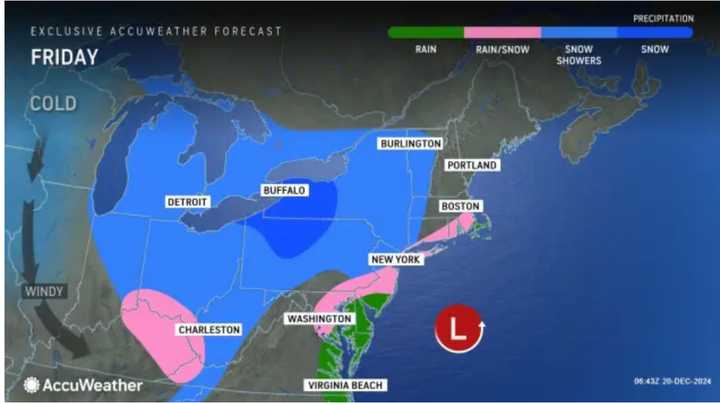
The merging of the two low pressure systems will occur late in the afternoon and into the evening on Friday, Dec. 20, the National Weather Service says.
Prior to that, there will be a chance for a mix of rain and slow in the morning.
Light snow is expected inland, while rain changing over to snow is expected along the coast.
"The danger is the snow can quickly erupt and come down at a steady clip in some areas during the afternoon and evening rush hour on Friday in the Northeast," said AccuWeather Chief On-Air Meteorologist Bernie Rayno, noting the risk includes the metro areas of New York City, Baltimore and Philadelphia, Allentown, Scranton and Harrisburg, Pennsylvania.
For a look at precipitation types by region, see the first image above from AccuWeather: rain (green), wintry mix (pink), snow showers (blue), and snow (dark blue).
"However, this will not be a heavy precipitation event, and 1 to 2 inches of snowfall is expected across the interior, while under an inch is in the forecast most everywhere else," says the National Weather Service.
Click on the second image above to see areas where accumulating snowfall is expected.
How quickly that the clipper's energy transfers to a budding coastal storm will have a detrimental impact on the intensity, duration and amount of snow that falls from the mid-Atlantic coast and central Appalachians through New England, said AccuWeather Senior Director of Forecasting Operations Dan DePodwin.
Areas farther south and east will see mainly rain or mixed precipitation at times.
Wind gusts could be as high as 20 miles per hour Friday night and up to 25 mph on Saturday, Dec. 21 as much colder air arrives.
The storm will move out from south to the north overnight into Saturday morning, followed by mostly sunny skies the rest of the day on Saturday and again on Sunday, Dec. 22.
Overnight low temperatures both Saturday into Sunday and Sunday into Monday, Dec. 23 will be in the teens and 20s.
Monday will be sunny with the high temperature generally in the upper 20s.
Check back to Daily Voice for updates.
Click here to follow Daily Voice East Windsor-Hightstown and receive free news updates.

