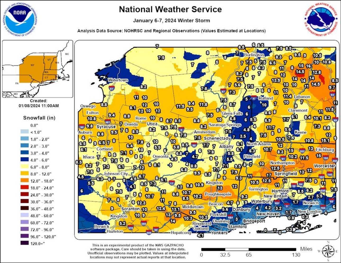
Totals are from the National Weather Service:
New York
Westchester County
Shrub Oak 4.0 inches 0600 AM 01/07 COOP
2 WNW Jefferson Valley 4.0 inches 0600 AM 01/07 CO-OP Observer
Hartsdale 3.5 inches 1040 PM 01/06 Trained Spotter
Croton-on-Hudson 2.9 inches 0945 PM 01/06 Public
White Plains 2.8 inches 1037 PM 01/06 Trained Spotter
Ossining 2.5 inches 0845 PM 01/06 Public
Peekskill 5.6 inches 01/07 Official NWS
Putnam County
Cold Spring 6.5 inches 0700 AM 01/07 COCORAHS
Nelsonville 0.3 S 6.0 inches 0700 AM 01/07 COCORAHS
Cold Spring 6.0 inches 0700 AM 01/07 Cocorahs
Nassau County
Manhasset Hills 0.5 inches 0736 PM 01/06 COCORAHS
Plainview 0.3 inches 0847 PM 01/06 Public
Suffolk County
Commack 1.3 SW 0.4 inches 0700 AM 01/07 COCORAHS
Commack 0.3 inches 0800 PM 01/06 Public
Ridge T inches 1159 PM 01/06 COCORAHS
Upton T inches 0700 AM 01/07 Official NWS Obs
Islip Airport T inches 0700 AM 01/07 Official NWS Obs
Orient Point T inches 0700 AM 01/07 COOP
Manhattan
Central Park 0.2 inches 0700 AM 01/07 Official NWS Obs
Dutchess County
Beacon, 4.7 inches 01/07 Official NWS
Poughkeepsie, 13 inches 01/07 Official NWS
Orange County
2 SE Port Jervis 13.1 inches 0630 AM 01/07 COCORAHS
3 NNE Unionville 12.4 inches 1253 AM 01/07 Public
Middletown 11.8 inches 1215 AM 01/07 Fire Dept/Rescue
Montgomery 11.0 inches 1130 PM 01/06 Public
3 SSW Pine Bush 9.5 inches 1201 AM 01/07 Public
Salisbury Mills 9.2 inches 0500 AM 01/07 Trained Spotter
Newburgh 9.0 inches 1125 PM 01/06 Public
2 SSW Stewart Airport 9.0 inches 1205 AM 01/07 Public
1 WNW Monroe 8.0 inches 1230 AM 01/07 Trained Spotter
2 E Highland Mills 7.5 inches 1212 AM 01/07 Public
Warwick 7.0 inches 1030 PM 01/06 Public
Chester 5.5 inches 1015 PM 01/06 COCORAHS
Highland Mills 4.8 inches 1026 PM 01/06 Public
Firthcliffe 2.9 inches 0954 PM 01/06 Public
West Point 2.5 inches 0940 PM 01/06 Trained Spotter
Rockland County
Stony Point 4.0 inches 0700 AM 01/07 COCORAHS
Blauvelt 3.5 inches 0922 PM 01/06 Public
New City 3.0 inches 1135 PM 01/06 Trained Spotter
2 W Buchanan 3.0 inches 0720 AM 01/07 Public
Capital Region
Albany, 5.8 inches 01/07 Official NWS
Saratoga Springs, 10 inches 01/07 Official NWS
Schenectady, 7.7 inches 01/07 Official NWS
Ulster County
Kingston, 8.8 inches 01/07 Official NWS
Sullivan County
Monticello, 11 inches 01/07 Official NWS
Queens County
NYC/La Guardia 0.3 inches 0700 AM 01/07 Official NWS Obs
Little Neck 0.3 SE 0.3 inches 0700 AM 01/07 COCORAHS
NYC/JFK 0.1 inches 0700 AM 01/07 Official NWS Obs
Howard Beach T inches 0700 AM 01/07 COCORAHS
Connecticut
Fairfield County
4 SSE Sherman 6.0 in0701 AM 01/07 Trained Spotter
Greenwich 4.5 inches 1200 AM 01/07 Public
Redding 4.0 inches 1209 AM 01/07 Public
Ridgefield 2.4 NNE 3.9 inches 0700 AM 01/07 COCORAHS
Stamford 3.5 inches 1022 PM 01/06 Public
2 S New Canaan 3.0 inches 0850 PM 01/06 Public
1 SE Wilton 3.0 inches 1016 PM 01/06 Public
1 NNW Rowayton 3.0 inches 1138 PM 01/06 COCORAHS
Bridgeport Airport 3.0 inches 0700 AM 01/07 Official NWS Obs
Norwalk 3.0 inches 0700 AM 01/07 COCORAHS
Norwalk 2.8 inches 1100 PM 01/06 Public
Bethel 2.5 inches 0620 AM 01/07 Emergency Mngr
3 E Easton 2.4 inches 1140 PM 01/06 Public
3 WSW Shelton 2.1 inches 0710 AM 01/07 Trained Spotter
Stratford 2.0 inches 0600 AM 01/07 COCORAHS
Newtown 5.3 S 1.9 inches 0700 AM 01/07 COCORAHS
Stratford 1.8 inches 1028 PM 01/06 Trained Spotter
Ridgefield 1.8 inches 0630 AM 01/07 COCORAHS
Newtown 1.3 inches 1045 PM 01/06 Public
Trumbull 2.6 SSE 1.3 inches 0730 AM 01/07 COCORAHS
Middlesex County
Durham 3.2 inches 0700 AM 01/07 COCORAHS
Middlefield 1.4 W 2.5 inches 0600 AM 01/07 COCORAHS
Moodus 0.7 SSW 1.7 inches 0700 AM 01/07 COCORAHS
Westbrook 0.8 inches 0742 AM 01/07 Trained Spotter
Westbrook 0.5 inches 0942 PM 01/06 Trained Spotter
New Haven County
1 E North Haven 3.0 inches 1215 AM 01/07 Trained Spotter
Naugatuck 3.0 inches 0700 AM 01/07 COCORAHS
Guilford 2.5 inches 0645 AM 01/07 CO-OP Observer
Seymour 1.2 WSW 2.5 inches 0700 AM 01/07 COCORAHS
Wallingford 2.0 inches 1200 AM 01/07 Trained Spotter
Milford 1.2 inches 0910 PM 01/06 Public
Madison 0.7 inches 0700 AM 01/07 Public
Meriden 0.5 inches 0915 PM 01/06 Trained Spotter
East Haven 0.3 inches 0915 PM 01/06 Trained Spotter
New London County
Norwich 2.7 inches 0600 AM 01/07 COCORAHS
Norwich 2.0 inches 0700 AM 01/07 COOP
Waterford 0.8 inches 0700 AM 01/07 COCORAHS
Preston 0.7 inches 0730 AM 01/07 COCORAHS
Niantic 0.5 inches 0600 AM 01/07 COCORAHS
Uncasville 0.5 inches 0700 AM 01/07 COCORAHS
Niantic 0.3 inches 0915 PM 01/06 Trained Spotter
Old Lyme 0.3 inches 0700 AM 01/07 COCORAHS
Hartford County
2 SW North Granby 11.0 inches 0840 AM 01/07
1 SE West Hartford 10.0 inches 0700 AM 01/07
3 N Canton 9.5 inches 0656 AM 01/07 Trained Spotter
Windsor 8.5 inches 0935 AM 01/07
Bradley AP 8.2 inches 0700 AM 01/07 ASOS
3 S Simsbury 8.0 inches 0700 AM 01/07
North Granby 7.0 inches 0900 AM 01/07
2 WNW Farmington 7.0 inches 1053 AM 01/07
3 ENE East Windsor 5.0 inches 1032 AM 01/07
Southington 4.2 inches 0855 AM 01/07
3 SE Enfield 4.0 inches 0804 AM 01/07
1 NNE Wethersfield 4.0 inches 0830 AM 01/07
1 WSW Marlborough 3.0 inches 0700 AM 01/07
Tolland County
Staffordville 6.5 inches 0500 AM 01/07 COOP
4 S Tolland 6.0 inches 0852 AM 01/07
1 NNE Somers 4.5 inches 0700 AM 01/07
1 NW Andover 4.0 inches 0911 AM 01/07
Windham County
Woodstock 6.0 inches 0930 AM 01/07
1 NE Eastford 5.5 inches 0820 AM 01/07
3 ENE Killingly 4.0 inches 0805 AM 01/07
Moosup 1.7 NE 3.3 inches 0600 AM 01/07 COCORAHS
East Killingly 1.3 SW 2.8 inches 0645 AM 01/07 COCORAHS
Click here to follow Daily Voice White Plains and receive free news updates.