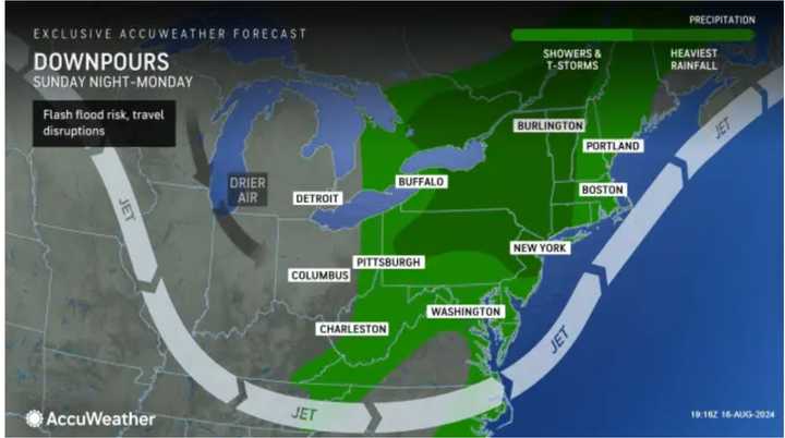
AccuWeather.com states the storms will "tap into a growing zone of warm and moist air from the Appalachians to the Atlantic coast. This will lead to drenching showers, thunderstorms, and the possibility of localized severe weather and flash flooding."
There will be repeated downpours at times throughout Sunday and Monday.
"Isolated to scattered instances of flash flooding are possible today and tonight," the National Weather Service said in a Hazardous Weather Outlook statement issued early Sunday morning.
Hurricane Ernesto will continue to produce waves around six feet at ocean beaches through Sunday. Dangerous rip currents can be expected into the early part of the week.
Areas in the darkest shade of green in the first image above from AccuWeather.com are expected to see the heaviest rainfall in the afternoon and evening on Sunday into Monday.
The National Weather Service said flash flooding may be possible due to the locally heavy rain, noting rainfall rates of 1 to 2 inches an hour are possible in some spots. About 4 inches of total rainfall is possible.
Hurricane Ernesto, which made landfall on Bermuda just before daybreak on Saturday, Aug. 17, is now headed north-northeast.
Though Ernesto's projected path takes it hundreds of miles from the East Coast, dangerous rip currents and rough surf will occur in coastal areas marked in red in the second image above through early this week.
Rain, which will be heavy at times, and scattered showers will occur throughout Sunday.
Storms will become likely from the early afternoon into Sunday night and at times on Monday into early Monday morning, which will start off with patchy morning fog.
More storms are possible Monday night into Tuesday, Aug. 20. There will be gradual clearing Tuesday and skies will become partly sunny. The high temperature will be around 70 degrees.
Wednesday, Aug. 21, will be mostly sunny with a high in the low to mid-70s.
The outlook for Thursday, Aug. 22 calls for sunny skies, with a high in the upper 70s.
Check back to Daily Voice for updates.
Click here to follow Daily Voice White Plains and receive free news updates.

