Find Your Daily Voice
 45°
45°
Severe Weather Threat Upgraded For Region: Here's Time Frame For Approaching Thunderstorms
The threat of severe weather from an approaching round of thunderstorms has just been upgraded for most of the region.
Storm activity is expected from west to east from 6 p.m. to 11 p.m. Saturday, April 1.
The area covers New York City, Long Island, Westchester, Rockland, Putnam, and Orange counties, and Fairfield, New Haven, Middlesex, and New London counties in Connecticut. (See the image above.)
"The Storm Prediction Center has placed the area in an enhanced risk of severe thunderstorms this evening," the National Weather Service said in a statement issued mid-Saturday afternoon. "…
Ida Rips Through Region, Causing Power Outages, Flooding, Road, School Closures
Three days after making landfall in Louisiana as a Category 4 hurricane, Ida ripped through the Northeast, wreaking havoc with numerous power outages, flooding, and road and school closures on Thursday, Sept. 2.
Several tornadoes triggered by the massive storm were reported in New Jersey and Pennsylvania.
At least eight people were killed in New York during the height of the storm, including three men, three women and a 2-year-old boy died in flooding incidents in the city.
States of emergency have been issued for much of the Northeast, including New York City and surrounding counties, whe…
Severe Thunderstorm Watch In Effect For Parts Of Region With Strong Winds, Tornadoes Possible
A Severe Thunderstorm Watch has now been issued for parts of the region.
It lasts until 11 p.m. Monday, June 21, and covers Dutchess, Ulster, Sullivan, Greene, Albany, Columbia, Delaware, Otsego, Rensselaer, and Schenectady counties in New York, Litchfield County in Connecticut, and Berkshire County in Massachusetts.
Torrential rainfall is possible during storm activity. Large hail of 1 inch in diameter or greater, damaging winds, and an isolated tornado or two are the main threats, said the National Weather Service, which issued the watch.
More storms are expected again on Tuesd…
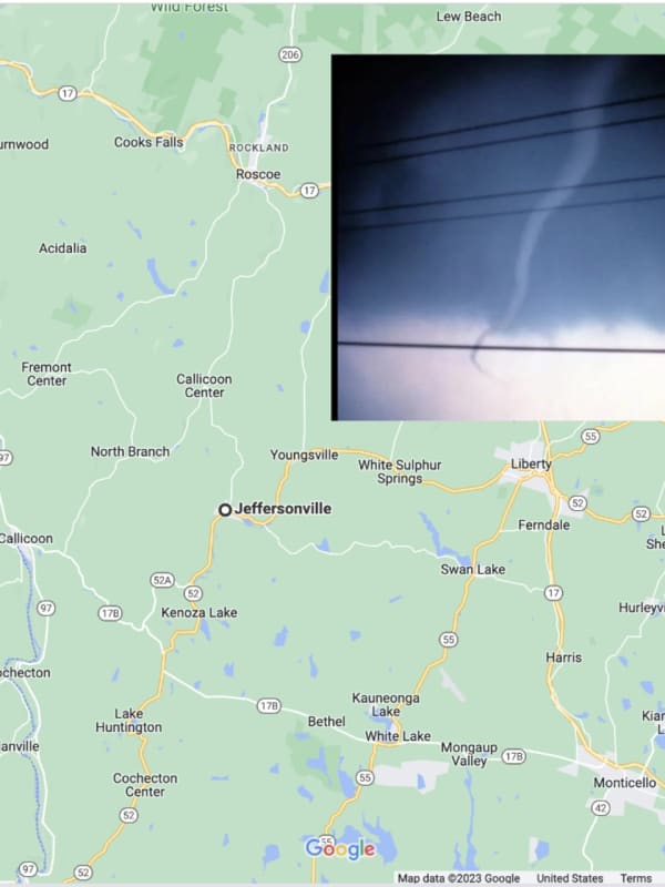
Possible Tornado Touches Down In Area
Crews from the National Weather Service are on their way to New York's Hudson Valley to assess damage from a storm that many say produced a tornado.
The storms ripped through Dutchess County just before 3 p.m., on Wednesday, April 21, leaving in its wake downed power lines, split and toppled trees, and many without electricity.
Brian Montgomery, a lead meteorologist with the National Weather Service, said specialized crews left Albany early Thursday, April 22, and are expected in the Hopewell Junction area around noon to view damage in order to determine if a tornado touched down and if so,…
New Tornado Touchdown Confirmed In Region, Bringing Total To Three
A new tornado touchdown from severe storm activity in the region on Thursday, Aug. 27 has been confirmed.
The National Weather Service announced on Sunday, Aug. 30 that an Enhanced Fujita Scale (EF) 0 twister touched down in Kent, Connecticut, near the Dutchess County border in Litchfield County, at 3:31 p.m. Thursday.
An EF-0 twister, with winds of 65 to 85 miles per hour, is the weakest of six types of twisters. (See the scale at the bottom of this page.)
The Kent tornado had maximum wind speed of 80 to 85 miles per hour, an estimated path of 75 yards, and path length of about…