Find Your Daily Voice
Ulster Sullivan
Your Local News for Ulster and Sullivan Counties, New York
Sunday, apr 28
43°
Follow
News
Schools
Business
Obituaries
Police & Fire
Weather
Lifestyle
Politics
Sports
Traffic
Real Estate
Tags
Jobs
Shop
Support Us
Ulster Sullivan
Follow
Find Your Daily Voice
News
Schools
Business
Obituaries
Police & Fire
Weather
Lifestyle
Politics
Sports
Traffic
Real Estate
Tags
Jobs
Shop
Support Us
Home
About us
All sites
Advertise with us
Contact us
Terms of use
Privacy policy
Code of ethics
Site Map
© 2024 Cantata Media
43°
Sunday, apr 28
Tag:
Heat Index
Weather
Separate Rounds Of Storms Will Follow Hot, Humid Stretch
A days-long stretch of hot and humid weather will be followed by separate rounds of showers and thunderstorms that will lead to a change in the weather pattern. According to AccuWeather Senior Meteorologist Heather Zehr: "Temperatures early this week are topping out 10-15 degrees above normal from interior New England down through the mid-Atlantic, while coastal areas in New England will be closer to the historical average. Even those areas will warm up heading toward the middle of the week." The high temperature on Tuesday, Sept. 5, and Wednesday, Sept. 6 will range from the upper 80s to …
Weather
Widespread Round Of Storms Will Bring Gusty Winds, Drenching Downpours To Region
As dangerously hot summer conditions persist in the region, there will be multiple chances for thunderstorms during an unsettled stretch of weather that will last through the weekend. Storms will be widespread on Friday, Aug. 5, and linger into Saturday, Aug. 6, with areas in dark green in the first two images above seeing the heaviest rainfall. Heat index values (the combination of the temperature and humidity) between 95 to 100 degrees are expected, according to the National Weather Service. Friday will be mostly cloudy for most of the day, and the high temperature will reach the lo…
Weather
Separate Rounds Of Storms Will Bring Drenching Downpours To Region
Separate rounds of thunderstorms will bring drenching downpours to the region, marking the start of an unsettled weather pattern that will linger into next week. Heat index values (the combination of the temperature and humidity) between 95 to 105 degrees are expected on Thursday, Aug. 4, and between 95 to 100 on Friday, Aug. 5, according to the National Weather Service. Thursday will be mostly sunny will a high temperature in the mid 90s. Clouds will thicken in the late afternoon, and there will be a possibility of scattered thunderstorms, with the storm chance becoming more likely in…
Weather
Simply Scorching: 'Misery Index' Could Hit 115 Degrees Before Storms Bring Relief
The combination of the temperature and humidity of the air is officially known as the heat index. But the informal label -- called the Misery Index - will be a lot more appropriate on Monday, July 20. Steamy, unhealthy, dangerously hot conditions will reach their heat on Monday as that Misery Index which will soar between 110 to 115 degrees in some parts of the region. (See image above.) A Heat Advisory issued by the National Weather Service, is in effect until 8 p.m. Monday, July 20. Monday will be partly sunny with the actual high temperature in the low to mid 90s. Due to the high …
Weather
Get Set For Long Stretch Of Stormy, Hazy, Hot Days
It will be hazy, hot and humid with several chances for thunderstorms this week. Sunday, July 5 will see skies clear after morning clouds, with the high temperature around 90 degrees. It will be sunny on Monday, July 6 with the high temperature again around 90 degrees. There will be a 50-50 chance for scattered showers and thunderstorms after 1 p.m. Monday through the evening. Tuesday, July 7 will be partly sunny with the high temperature in the mid 80s. The storm chance returns Wednesday, July 8, which will be partly sunny with the high temperature around 90 degrees. Temperatures could…
Weather
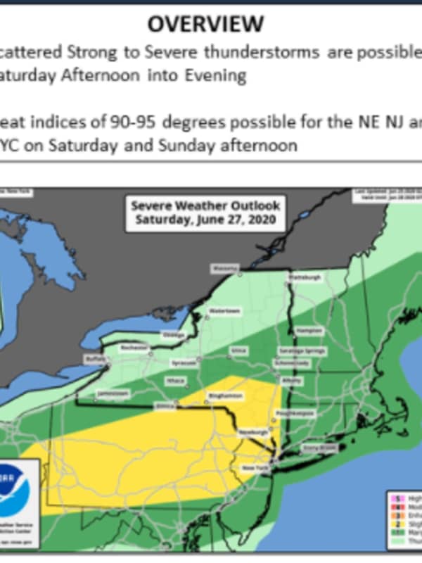
Severe Weather Watch: Strong Thunderstorms With Damaging Wind Gusts Expected
Severe thunderstorms with damaging winds are expected across the region this weekend. The storms will be scattered and in the afternoon and evening on Saturday, June 27. The most likely time frame for storms is between 3 p.m. and 9 p.m. Saturday. Damaging winds that could cause power outages are the biggest threat, the National Weather Service said in a Hazardous Weather Statement issued early Saturday morning. It will be a hazy, hot and humid day with the high temperature in the mid 80s, but heat indices of 90 to 95 degrees. Showers are possible from around 9 a.m. through late Satu…
Weather
Severe Weather Alert: Rounds Of Strong Thunderstorms With Damaging Winds Headed To Area
There will be a big change in the weather pattern following another sunny and warm day. Friday, June 26 will be mostly sunny and a bit more humid with the high temperature in the mid 80s. Then comes the big change as a warm front approaches the area overnight. Possible strong to severe thunderstorms are possible on Saturday, June 27 both in the afternoon into the evening across the region. Heat indices of 90 to 95 degrees possible over the weekend. The storm chance starts around 3 p.m. Saturday, which will be mostly cloudy with a high temperature in the low 80s. The window for stron…