
The massive system is expected to move in from the south and west Saturday, Jan. 6 into Sunday, Jan. 7.
Widespread plowable snowfall of more than 3 inches is possible in a large portion of the region (areas shown in teal in the first image above from the National Weather Service.)
Areas expected to see the most snowfall are shown in red and sky blue.
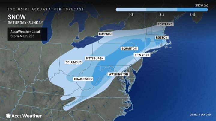
In the second image above from AccuWeather.com areas in the darker shade of blue could see between 6 and 12 inches of snowfall, including parts of upstate New York, northern Connecticut, and areas in Massachusetts as well as parts of New Jersey, Pennsylvania, Maryland, Virginia, and West Virginia.
Snowfall could result in hazardous driving conditions and travel disruptions.
“The timing of this storm is also problematic because many colleges and universities resume classes early next week," AccuWeather Chief Meteorologist Jon Porter said, "so students and families should make sure to stay updated on the latest forecast along the route of their trip back to school and consider adjusting travel plans accordingly.
"Flight cancellations and delays are also expected at the major airports in the Northeastern United States, which can have cascading effects resulting in cancellations and delays in other parts of the country, especially later Saturday into Sunday.”
The days leading up to the storm's arrival will be dry with a mix of sun and clouds and temperatures generally in the 40s before falling into the 30s on Friday, Jan. 5.
Clouds will increase on Saturday in advance of the storm's arrival. The high temperature will be in the mid-30s and the overnight low will dip just below the freezing mark.
According to current models, most of the snowfall will be between Saturday night and Sunday morning and should wind down around midday Sunday.
There's still uncertainty surrounding the timing and strength of the system and it's still unclear where "the heaviest axis of snow" could form, according to the National Weather Service.
This continues to be a developing story. Check back to Daily Voice for updates.
Click here to follow Daily Voice Suffolk and receive free news updates.