Find Your Daily Voice
Putnam
Your Local News for Putnam County, New York
Saturday, apr 27
44°
Follow
News
Schools
Business
Obituaries
Police & Fire
Weather
Lifestyle
Politics
Sports
Traffic
Real Estate
Tags
Jobs
Shop
Support Us
Putnam
Follow
Find Your Daily Voice
News
Schools
Business
Obituaries
Police & Fire
Weather
Lifestyle
Politics
Sports
Traffic
Real Estate
Tags
Jobs
Shop
Support Us
Home
About us
All sites
Advertise with us
Contact us
Terms of use
Privacy policy
Code of ethics
Site Map
© 2024 Cantata Media
44°
Saturday, apr 27
Tag:
Winter Weather Advisories
Weather
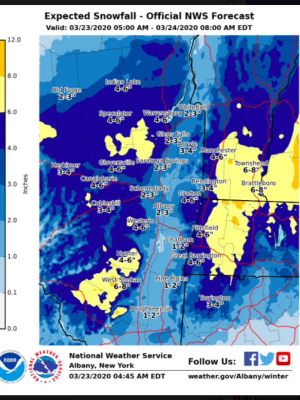
Eye Of The Storm: Here Are Brand-New Snowfall Projections
A storm system bringing accumulating snow to inland areas and rain at times to the entire region has arrived. Precipitation arrived as light, wet snow north of I-287 and the Merritt Parkway and as rain farther south just before daybreak on Monday, March 23. After a lull later in the morning, precipitation will return around 2 p.m. As the temperature will be above freezing south of I-84, it will be rain. But north of I-84, anywhere from 2 to 6 inches is expected with locally higher amounts. (See first image above.) For a look at counties where winter storm warnings (pink) and winter w…
Weather
Projected Snowfall Totals Updated As Nor'easter Arrives
Click here for rundown of school closures, delays New projected snowfall for the Nor'easter arriving early Thursday morning show the storm's strongest impact will be east of the Hudson River, especially areas south and east. Much of Westchester and Fairfield counties should see 6-10 inches or more of accumulation. West of the Hudson, including Rockland and Orange counties, lesser amounts are predicted. Winter Storm Warnings now include all of Westchester, Putnam, Rockland, Fairfield and Bergen counties from 1 a.m. Thursday until 1 a.m. Friday. Winter Weather Advisories are in effect elsewh…

 44°
44°