Find Your Daily Voice
 47°
47°
Chance Of Snow For NJ, PA In Sunday Soaker: Forecasters
Temperatures are expected to surge near 60 by the end of the week, but come next, parts of New Jersey and Pennsylvania could be back in old man winter's grip, forecasters say.
According to AccuWeather, a storm on Sunday, Jan. 29 will bring rain to major cities.
For northwest New Jersey, northern Pennsylvania and parts of Central Pennsylvania, however, a mix of rain and snow — or perhaps just snow — is expected.
Thursday, Jan. 25 will be rainy and foggy with a high near 50 while Friday, Jan. 26 will be the same but slightly cooler, the NWS said. Saturday will be partly sunny with a hi…
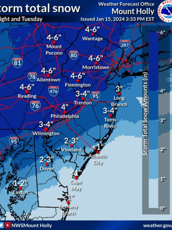
Six Inches Of Snow Could Slam Parts Of NJ, PA: Latest Forecast, Timing Updates
Newly-released forecast maps from the National Weather Service show up to six inches of snow could fall across eastern Pennsylvania and much of New Jersey.
Accumulating snowfall will begin Monday, night Jan. 15, mainly after 7 p.m., and carry into Tuesday morning, Jan. 16, impacting the morning commute as it changes over to a wintry mix, the NWS said in its latest briefing.
ALSO SEE: North Jersey School Delays For Tuesday, Jan. 16
Between 4 and 6 inches of snow was being forecast for most of North Jersey (including Morris, Sussex, pars of Bergen/Essex/Hudson, Warren, and Hunterdon Counties…
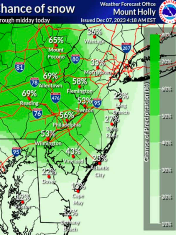
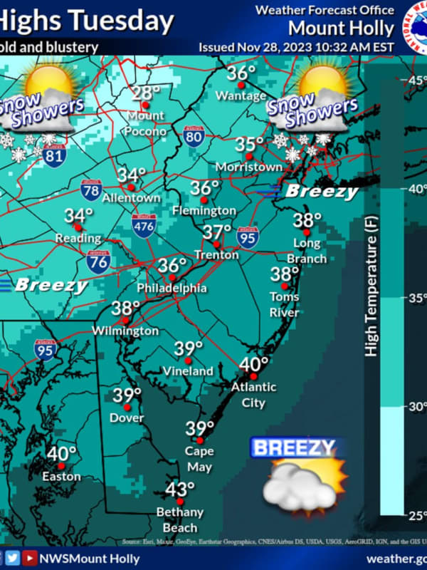
Snow Flurries Possible This Evening In Parts Of North Jersey
Wintry weather may be working its way through parts of North Jersey later today, Tuesday, Nov. 28.
The National Weather Service was predicting up to a 40 percent chance of flurries in the northern and westernmost parts of the state in the late afternoon and evening hours.
Bergen, Passaic, Essex, Morris, Union, Sussex, Warren, and Hunterdon counties could all see snow through the evening, according to the NWS.
The greatest chance of snow is in Sussex County, where the NWS predicted a 40% chance of flurries before 5 p.m.
🥶🧥 Temperatures will remain steady in the 30s for the remainder o…
'Temperature Turnaround:' Unseasonably Warm Weather Coming To Northeast
Mother Nature isn't ready for winter yet — or fall, for that matter.
While this week got off to a chilly start in the Northeast, the finish will be anything but, forecaster say.
Tuesday, Oct. 24, and Wednesday, Oct. 25 will be sunny with temps in the high 60s, Thursday, Friday, and Saturday will reach highs around 75.
In Philadelphia, Washington DC, and Baltimore, temperatures could climb as high as 80, AccuWeather says, calling it a "temperature turnaround."
The forecast low tonight in Philly is 40°. The last time the low was 40° or less in Philly this year was April 10, when... Pos…
Two Inches Of Snow Possible 'If Everything Lines Up Just Right' In Northeast
If everything lines up just right this weekend, parts of the Northeast could get up to two inches of snow, the National Weather Service says.
More likely than not, though, those areas will see just a light coating, "if that," the NWS said.
Good morning! If you're hoping for snow, this is the best we can do for now. A weak system will pass to our south Sunday... Posted by US National Weather Service Philadelphia/Mount Holly on Friday, January 6, 2023
Temps on Saturday, Jan. 7 will be in the mid-40s with a low of 29, and on Sunday, the high will be 42 with a low of 32.
A map from AccuWe…