Find Your Daily Voice
 45°
45°
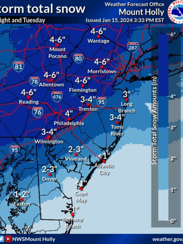
Six Inches Of Snow Could Slam Parts Of NJ, PA: Latest Forecast, Timing Updates
Newly-released forecast maps from the National Weather Service show up to six inches of snow could fall across eastern Pennsylvania and much of New Jersey.
Accumulating snowfall will begin Monday, night Jan. 15, mainly after 7 p.m., and carry into Tuesday morning, Jan. 16, impacting the morning commute as it changes over to a wintry mix, the NWS said in its latest briefing.
ALSO SEE: North Jersey School Delays For Tuesday, Jan. 16
Between 4 and 6 inches of snow was being forecast for most of North Jersey (including Morris, Sussex, pars of Bergen/Essex/Hudson, Warren, and Hunterdon Counties…
Stormy Sunday, Monday: Cold, Rainfall Up To 3 Inches, Freezing Drizzle
Don't adjust your calendar.But it definitely does feel more like mid-February than mid-April, especially following a stretch of back-to-back days of true spring weather.
That trend will continue the next couple of days with heavy rain, possible thunderstorms, brisk winds and even the possibility of freezing rain in areas farther north.
The potential for pockets of freezing rain and drizzle into Sunday evening, mainly in higher elevations, is for Northern Westchester, Putnam Dutchess, Rockland, Orange, Northern Fairfield and Western Passaic. A glaze of ice accretion is possible.
A period of…