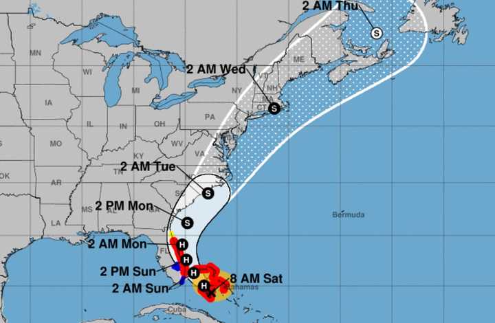
“What usually happens with tropical cyclones as they move northward is the heaviest rain tends to fall to the west of the track and the center, while the strongest winds tend to be to the east of the track,” meteorologist Joe Cioffi said.
Predicting weather accurately days in advance is next-to-impossible, with meteorologists making their most educated guesses and hoping for the best.
Now and then, certain expectations are more reasonable, though.
To Cioffi, Isaias looks like “a minimal hurricane, at best, or a strong tropical storm.”
“Tuesday will be the main threat day,” he said Saturday. “It will be a 6- to 8-hour period of rain and wind.
“If it goes according to plan, by Wednesday morning daybreak, it should be gone and weather conditions will improve rather quickly.”
Isaias’s heaviest New Jersey rainfall will likely be two to four inches, Cioffi said.
The heaviest winds are more likely to hit New York City, Long Island and southern New England late Tuesday, with speeds of 30 to 50 mph, he said.
“In the meantime we have a nice start to [Saturday], with lots of blue skies and sunshine,” Cioffi said. “It will be a warm and moderately humid day with highs in the 80s.
“Most lows overnight will be in the upper 60s to middle 70s.”
Tropical air surges in on Sunday, “priming the atmosphere for the arrival of Isaias on Tuesday,” Cioffi said. “Sunday will be very warm and very humid....[It] will make it feel like Florida.
“Monday we will probably see some sun and high clouds with highs in the low to mid 80s,” he added. “We could see some showers Monday night into Tuesday well ahead of Isaias, which will come barreling up the coast later in the day Tuesday and Tuesday night.”
Click here to follow Daily Voice Mahwah-Ramsey and receive free news updates.
