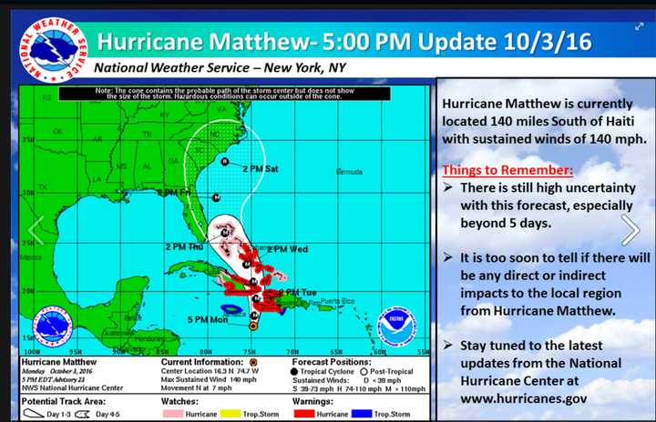
"The track and structure would suggest that the effects for New Jersey northeastward to Southern New England would be much like a winter time nor’easter and a fairly strong one," Cioffi said late Monday.
There very likely will be no direct landfall in New Jersey, he said.
"However, it could be a stormy Saturday night and Sunday morning especially along the New Jersey shore," Cioffi said.
The "reflexive comparisons" between the latest threat and the historic superstorm that slammed New Jersey are understandable, Cioffi said, but there are some significant differences.
"What made Sandy especially destructive was the fact that it came in from the Southeast, which resulted in the tidal surge being pushed from the Bahamas right into our shoreline," he said. "There was no prior landfall.
"This was a generational event, since very few storms have ever tracked this way."
What's more, Cioffi said, the weekend will have the first quarter-moon, "which puts us in a low tide cycle."
"Sandy came at a high tide cycle near a full moon and came in near the actual high tide," he said. "It was a deadly and damaging combination.
"Even if Hurricane Matthew were to come at high tide, it would not cause the tidal flood to the extent that Hurricane Sandy did."
"The center does not cross any land mass until it gets to southeastern Massachusetts," Cioffi said. "This transition and track would bring heavy and potentially drought breaking rains to much of the rain starved areas of the Northeast."
Matthew might have started at Category 4 status, but the chances of it being stronger than Category 2 when arrives here are "very low," the veteran meteorologist said.
"In fact, it is quite possible that Hurricane Matthew will transition over to a post tropical storm or hurricane," he said.
"The pattern we have here is much less dynamic [than with Sandy]", Cioffi said. "If this transition to a post tropical system takes place, it would shift the heaviest rains to the west side of the center of low pressure.
"The result of this is that it might just behave like a winter type noreaster albeit a rather fierce one."
This isn't to minimize Matthew, Cioffi said.
"We may not know that for sure for a few more days," he said. "But I think its important to realize that hurricanes like Sandy are once-in-a-generation-type event.
"It is understandable that in everyone’s mind it is the 'go-to' storm when the word hurricane comes up," Cioffi said. "I just want to put it in perspective.
"You still will need to prepare if Hurricane Matthew is a threat but do so in a calm logical way. You should follow the recommendations of local officials if the time comes that any decision has to be made."
Click here to follow Daily Voice Hackensack and receive free news updates.
