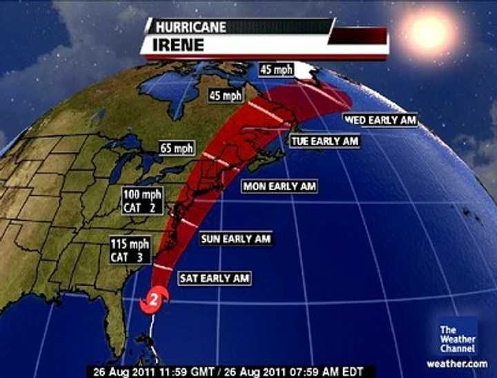
Tropical storm conditions will stretch into western New Jersey and upstate New York through the Hudson River Valley. New England could end up getting the worse of it, although we have no reason at this point NOT to be concerned.
Florida, Georgia and most of South Carolina are relatively safe, except for rainstorms, at this point. But forecasters are figuring rain and wind will definitely create havoc in Maryland, Delaware and South Jersey tonight.
As of 12:30 this afternoon, the center of Hurricane Irene was bound for Cape Hatteras, NC, at winds near 105 miles per hour, and is expected to bump the Carolina coastline sometime tonight before making landfall tomorrow.
Hurricane Irene was upgraded to Category 2 around 8 a.m. today, as fears grew that it may be one of the hardest ever to hit our area.
“We added an ‘EXTREME’ threat level category from eastern North Carolina to southern New England,” the Weather Channel reported around the same time.
CLIFFVIEW PILOT EXCLUSIVE REPORT: Massive power outages and flooding will likely continue past midnight tonight, as New York runoff swells the already overflowing Hackensack River, Pascack Brook and area reservoirs, making an already bad situation much worse, Bergen County leaders told mayors and other government officials during a 15-minute emergency conference call this afternoon. READ MORE ….
The wind coverage was 430 miles wide — larger than Katrina (2005) and Ike (2008).
“This is a particularly threatening situation and it’s best for people to be on alert,”said its hurricane expert, Dr. Rick Knabb.
Unless the path changes, we’re expected to get the brunt of it beginning Saturday night and into Monday. At the moment, we are one notch below “Catastrophic” following the 8 a.m. upgrade.
“Computer models are currently trending toward a forecast solution of rare potency for portions of the Northeast,” the Weather Channel was reporting. “Hurricane Irene is likely to be the most impactful hurricane to hit the East Coast in at least several decades.”
That includes Norfolk, Washington, D.C., Baltimore, Philadelphia, New York City, Hartford, and Boston.
United Water OKs controlled releases as Christie considers executive order
Thursday, 25 August 2011 20:26 Jerry DeMarco
CLIFFVIEW PILOT BREAKS THE STORY: Following intervention by Assemblyman Robert Schroeder, with the potential of a direct order from Gov. Christie, United Water began controlled releases of water from its reservoirs Thursday afternoon to mitigate expected flooding from Hurricane Irene. READ MORE….
Don’t need to tell you the casinos are closing. Margate Bridge: one way out.
There have been only 5 hurricanes whose centers of circulation have passed within 75 miles of New York City since 1851. The last was Hurricane Gloria, which did significant damage to the Jersey Shore and Long Island, 26 years ago.
The last large-scale destructive one to hit New Jersey was the Great Hurricane of 1944.
“This hurricane has the potential to produce flooding rains, high winds, downed trees (on houses, cars, power lines) and widespread power outages,” weather.com reports. “Significant impacts along the immediate coast include high waves, surge and beach erosion.”
The silver lining? There remain “critical uncertainties” about the Irene’s exact track and intensity. Maybe she zigs instead of zags and we are spared the worst.
Hurricane tips you might not have considered
Friday, 26 August 2011 09:07 Jerry DeMarcoCLIFFVIEW PILOT SPECIAL: If Hurricane Irene kills your electricity, don’t dial 911. If you need a machine to keep organs working, call your local emergency management office — TODAY. And do not, under any circumstances, drive through standing water. Why? Here are some critical tips you might not know. READ MORE….
{loadposition log}
Click here to follow Daily Voice Hackensack and receive free news updates.
