Excessive Heat Watch Issued For Most Of DMV Region With Temperatures Approaching 100 Degrees Excessive Heat Watch Issued For Most Of DMV Region With Temperatures Approaching 100 Degrees Excessive Heat Watch Issued For Most Of DMV Region With Temperatures Approaching 100 Degrees
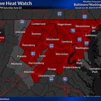
Excessive Heat Watch Issued For Most Of DMV Region With Temperatures Approaching 100 Degrees Forecasters are cautioning that oppressive heat may be headed to the DMV region with temperatures possibly approaching 100 degrees in the area. The National Weather Service announced that an Excessive Heat Watch has been issued for Saturday, June 20 with possible heat index values touching 105 to 110 degrees in certain parts of DC, Maryland, and Virginia. National Weather Service It will be in effect from noon through 8 p.m. on Saturday, June 22. Residents have been advised to:  Stay in air conditioning and out of the sun, if possible; Check on friends, family, neighbors, and…
6 Tornados Touched Down In VA, MD: Here's Where 6 Tornados Touched Down In VA, MD: Here's Where 6 Tornados Touched Down In VA, MD: Here's Where
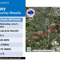
6 Tornados Touched Down In VA, MD: Here's Where The National Weather Service confirmed seven tornados touched down in Maryland, West Virginia, and Virginia on Wednesday, June 5 — six of them in the DMV alone. The NWS sent four teams to cities across the region to survey storm damage and found a warm front slowly lifted northeast across the eastern Panhandle of West Virginia into northern Virginia, along with central and northeastern Maryland.  At the same time, low pressure tracked along the warm front causing severe thunderstorms and tornadoes to develop. Peak winds were between 85 and 105 mph, the strongest in  Seven of them. Here's w…
New Round Of Severe Thunderstorms Expected To Hit Maryland New Round Of Severe Thunderstorms Expected To Hit Maryland New Round Of Severe Thunderstorms Expected To Hit Maryland
New Round Of Severe Thunderstorms Expected To Hit Maryland A Severe Thunderstorm Watch has been issued by the National Weather Service one day after parts of Maryland had to contend with tornados that touched down. Hours after twisters tore through parts of the state, some residents are bracing for a fresh round of rain and thunderstorms that are expected to roll through the region on Thursday, June 6. National Weather Service Forecasters say that the area expected to get hit the hardest will be those along US 15 east toward Chesapeake Bay.  Another round of showers and t-storms is expected today with locally heavy rain and severe t-stor…
Twister Totals Home, Leaves Trail Of Destruction Across Montgomery County: What We Know Twister Totals Home, Leaves Trail Of Destruction Across Montgomery County: What We Know Twister Totals Home, Leaves Trail Of Destruction Across Montgomery County: What We Know
Twister Totals Home, Leaves Trail Of Destruction Across Montgomery County: What We Know Crews are out cleaning up a trail of destruction left by a tornado through Montgomery County, MD on Wednesday evening, June 5. Officials confirmed a tornado over Poolesville and Gaithersburg, however, residents across the area shared photos of uprooted trees, downed poles, and all-around wreckage left by the storm. The National Weather Service is deploying four survey teams to investigation the damage in nine counties across West Virginia, Virginia, and Maryland.  While a twister wasn't officially confirmed in Leesburg, residents shared footage of an ominous cloud hovering over t…
Multiple Tornado Warnings Issued Across Parts Of Maryland (UPDATED) Multiple Tornado Warnings Issued Across Parts Of Maryland (UPDATED) Multiple Tornado Warnings Issued Across Parts Of Maryland (UPDATED)
Multiple Tornado Warnings Issued Across Parts Of Maryland (Updated) Several tornado warnings have been issued in Maryland late on Wednesday morning as the region continues to grapple with rough weather. Early on June 5, an alert was issued in Charles County, which was quickly followed up across the state, according to the National Weather Service. Tornado Warning including Boonsboro MD, Myersville MD and Keedysville MD until 6:15 PM EDT pic.twitter.com/5hBZ7FsH5v — NWS Baltimore-Washington (@NWS_BaltWash) June 5, 2024 Tornado Warning including Owings Mills MD, Garrison MD and Hampstead MD until 6:45 PM EDT pic.twitter.com/8Y1lcjYX07 — NWS Baltimor…
Thunderstorms, Heavy Winds Heading Toward Virginia, Maryland: Forecasters Thunderstorms, Heavy Winds Heading Toward Virginia, Maryland: Forecasters Thunderstorms, Heavy Winds Heading Toward Virginia, Maryland: Forecasters
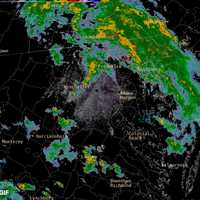
Thunderstorms, Heavy Winds Heading Toward Virginia, Maryland: Forecasters Several rounds of rain showers and thunderstorms are expected to roll through the DMV region on Wednesday, forecasters say. The National Weather Service issued an alert cautioning that storms were incoming and could bring wind gusts of up to 60 mph in some parts of the area. A Flood Watch was also put in effect for the DC/Baltimore metro areas that will be in effect from noon through 10 p.m. on Wednesday, June 5. "A pair of low pressure systems tracking across the eastern half of the country will trigger scattered to isolated showers and thunderstorms across much of the region to…