Find Your Daily Voice
Worcester
Your Local News for Worcester County, Massachusetts
Sunday, apr 28
44°
Follow
News
Schools
Business
Obituaries
Police & Fire
Weather
Lifestyle
Politics
Sports
Real Estate
Tags
Jobs
Shop
Support Us
Worcester
Follow
Find Your Daily Voice
News
Schools
Business
Obituaries
Police & Fire
Weather
Lifestyle
Politics
Sports
Real Estate
Tags
Jobs
Shop
Support Us
Home
About us
All sites
Advertise with us
Contact us
Terms of use
Privacy policy
Code of ethics
Site Map
© 2024 Cantata Media
44°
Sunday, apr 28
Tag:
Wind
Weather
System Bringing Showers, Storms, Snow In Some Spots Will Be Followed By Temperature Plunge
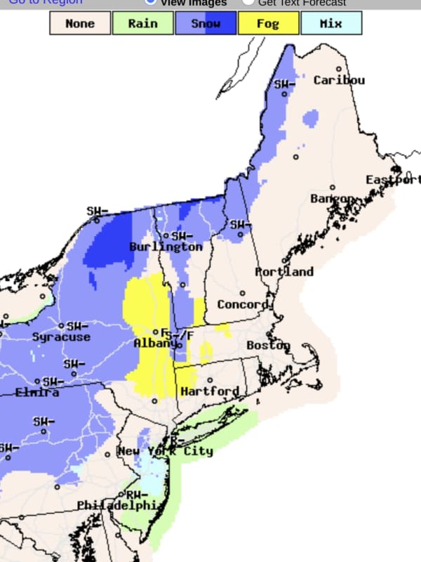
A new storm system bringing showers and thunderstorms to the region, and some snow to areas farthest north and inland, will be followed by a big change in the weather pattern for the second half of the weekend and start of the new workweek. "While this may not be the final blast of winter-like cold for the Northeast, it will certainly pack some punch," said AccuWeather Senior Meteorologist Brett Anderson. Expect spotty showers and thunderstorms at times on Saturday, March 26, but the day will not be a complete washout at all. The high temperature will be around 50 degrees, according to the …
Weather
Storm Will Bring Soaking Rain, Gusty Winds With Snow, Wintry Mix For Some Parts Of Region
A storm with periods of rain and gusty winds will also bring spring snowfall and a wintry mix in parts of the Northeast. The system, which has weakened after fueling tornadoes in the Southeast, arrives in this region late Wednesday afternoon, March 23. There will be rain and showers at times through early Friday morning, March 25, with the chance for snow in some areas farthest north and inland, especially overnight. Wednesday will be raw with the temperature in the mid 40s. "Wet conditions will last through Friday morning with 1 to 2 inches of rainfall expected," according to t…
Weather
Nor'easter Nears: Brand-New Projections For Snowfall Accumulation, Wind Speed Released
Brand-new snowfall projections have just been released by the National Weather Service for the major Nor'easter headed to the region. The time frame for the potent storm is early Friday evening, Jan. 28 into early Saturday evening, Jan. 29. "Confidence is increasing on a strong coastal storm impacting parts of Southern New England," the National Weather Service said just after sunset on Thursday, Jan. 27. "While some uncertainty remains with the exact track, we have higher confidence in significant snow/wind across eastern MA/RI with lower confidence farther inland." Besides the pote…
Weather
Here's Latest Time Frame For Storm System Bringing Heavy Rain, Gusty Winds To Region
A storm system will bring locally heavy rain and gusty winds to the region, ending a dry weather pattern in the region. The time frame for the storm is late Thursday night, Nov. 11 into early Friday afternoon, Nov. 12. The storm could cause poor drainage and urban flooding, including during the Friday morning commute, the National Weather Service said. It will be precipitation-free during the morning and afternoon on Veterans Day, Thursday, Nov. 11 with partly sunny skies and a high temperature in the upper 50s. The arrival of the storm system will bring widespread rain to the region…
Weather
Update: Expect A Polar Vortex, Snow, And Fierce Wind Over The Next 5 Days
Break out your best Bernie Sander's style knitted-mittens and extra-thick jackets, a polar vortex is about to descend on Massachusetts and much of New England. A blast of cold wind from Canada is expected to drop temperatures to as low as 20 degrees below 0. The oncoming polar vortex may also bring snow to Central and Western Massachusetts starting on Friday, Jan. 29. In these conditions, frostbite could start to form after 30 minutes outside. The National Weather Service has issued a “hazardous weather outlook” for the region between northern Connecticut and North Worcester County. The fo…
News
Forecasted Christmas Storm Intensifies, Local Travel May Be Affected
As the intensity of a Christmas storm increases, meteorologists are predicting local travel conditions may be difficult on Christmas Eve. The Thursday, Dec. 24, forecast calls for a 100 percent chance of rain in the evening and it will be heavy at times. Wind gusts are expected to reach 40 mph, according to the National Weather Service. The wet weather comes courtesy of a powerful low-pressure system and a strong cold front is expected to plow through the Central, Southern, and Eastern U.S. over the next few days - reaching Worcester County and Western Massachusetts just in time for the hol…
Weather
Storm Will Be Followed By Gusty Winds, Drop In Temperatures
A storm system that has swept through the region will be followed by clearing, gusty winds and a drop in temperatures. Some parts of the region will see as much as 2 inches of rainfall from the system, which will wrap up later in the morning on Monday, Nov. 23. Skies will gradually clear after noontime just as strong winds move in. The temperature will fall in the afternoon from the mid 50s to the mid 40s on a breezy day with wind strength of 10 to 15 miles per hour and gusts up to 25 mph. As a result, it will feel more like it's in the 30s by the time nightfall arrives. The overni…

 44°
44°