Tag:

Christmas Eve

After The Storm: Bitter Cold For Christmas Eve, Xmas Day Before Big Change In Weather Pattern After The Storm: Bitter Cold For Christmas Eve, Xmas Day Before Big Change In Weather Pattern
After The Storm: Bitter Cold For Christmas Eve, Xmas Day Before Big Change In Weather Pattern Let's hope Santa Claus is wearing an extra pair -- or two -- of long johns. That's because Christmas Eve and Christmas Day will be the coldest in decades. 
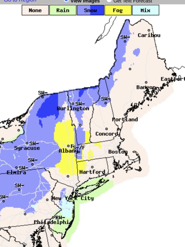
A powerful, massive storm that brought a mix of heavy rain, damaging winds, sleet, and snow, has now moved off the coast, but the passage of a cold front accompanying the system has led to a dramatic dip in temperatures. The wind-chill factor on Christmas Eve on Saturday morning, Dec. 24 is below zero degrees in most of the region. After a sunny start, clouds will increase during the day, but the high temperature will only be in the mid…
Storm With Heavy Rain, Strong Winds Will Be Followed By Rapid Freeze: Here's What's Coming Storm With Heavy Rain, Strong Winds Will Be Followed By Rapid Freeze: Here's What's Coming
Storm With Heavy Rain, Strong Winds Will Be Followed By Rapid Freeze: Here's What's Coming A potent pre-Christmas storm packed with damaging wind gusts bringing a mix of heavy rain, sleet, and snow to the region will be followed by a rapid freeze as temperatures plummet. The time frame for the storm is from Thursday afternoon, Dec. 22 to Friday evening, Dec. 23. With blizzard-like conditions in much of the Midwest, more than 1,000 flights have been canceled as of early Thursday morning. A total of between 2 to 3 inches or more of rainfall is possible. "Gusty winds could blow around unsecured objects," the National Weather Service said in a Hazardous Weather Outlo…
Snow Joke! Rounds Of Storms Will Bring Wintry Weather, Hazardous Travel Conditions At Times Snow Joke! Rounds Of Storms Will Bring Wintry Weather, Hazardous Travel Conditions At Times
Snow Joke! Rounds Of Storms Will Bring Wintry Weather, Hazardous Travel Conditions At Times Separate quick-moving systems will bring multiple wintry weather events across the region through Christmas. The first system has the potential for a light coating of snowfall, less than an inch, Thursday night, Dec. 23 into Friday morning, Dec. 24 for most of the region, with the potential for more snowfall farther north in New York and New England, according to the National Weather Service.  Another quick-moving low-pressure system will bring a light wintry mix of mainly sleet and freezing rain Christmas Eve night into early Saturday morning on Christmas Day, Dec.…
Dreaming Of A White Christmas? Here's A Day-By-Day Outlook Through Week's End Dreaming Of A White Christmas? Here's A Day-By-Day Outlook Through Week's End
Dreaming Of A White Christmas? Here's A Day-By-Day Outlook Through Week's End A storm system bringing a mix of rain, sleet, and snow has now pushed off the coast as brisk, blustery conditions have now arrived in the region. Temperatures will then become mild in the middle of the week, followed by a return to more seasonable conditions at the end of the week, with the possibility of a wintry mix Christmas Eve into early Christmas Day. Here's a day-by-day breakdown: Cloudy skies on Sunday, Dec. 19 will be followed by gradual clearing partly sunny skies in the afternoon with a high temperature in the upper 30s and wind-chill values between 25 and 30 degrees. Monday, D…
Here's Latest On Potential For New Year's Storm After Stretch Of Dry Days To Start Week Here's Latest On Potential For New Year's Storm After Stretch Of Dry Days To Start Week
Here's Latest On Potential For New Year's Storm After Stretch Of Dry Days To Start Week The final days of 2020, which will go down in the history books as a year like no other (to put it mildly), are expected to be relatively uneventful weather-wise, with a stretch of dry days with seasonably cold temperatures. But, perhaps fittingly, 2020 may have one last surprise in store. That's because a potentially powerful storm system is expected to sweep through the region New Year's Eve into New Year's Day. The fact it would follow the overnight storm that slammed the region Christmas Eve into Christmas Day is also a rarity. Like the Christmas storm, the system developing for New Y…
What's Open On Christmas Eve? Local Grocery, Retail Store Hours What's Open On Christmas Eve? Local Grocery, Retail Store Hours
What's Open On Christmas Eve? Local Grocery, Retail Store Hours If you need a last-minute item on Christmas Eve, many stores will be open until 6 p.m. with some exceptions staying open later. The following is a list of store closing times for Christmas Eve, Dec. 24, 2020, according to USA Today and retail websites. Aldi, 4 p.m. Best Buy, 7 p.m. Big Lots, 10 p.m. Big Y, 6 p.m., pharmacy closes at 4 p.m. BJ’s Wholesale Club, 6 p.m. Costco, 5 p.m. CVS, most stores are open regular hours on Christmas Eve and Day, pharmacy hours vary Dollar General, 10 p.m. Fresh Market, 7 p.m. Home Depot, 5 p.m. Home Goods, 6 p.m. Kohl’s, 6 p.m. Lowe’s, 6 p.m. Market Baske…
Forecasted Christmas Storm Intensifies, Local Travel May Be Affected Forecasted Christmas Storm Intensifies, Local Travel May Be Affected
Forecasted Christmas Storm Intensifies, Local Travel May Be Affected As the intensity of a Christmas storm increases, meteorologists are predicting local travel conditions may be difficult on Christmas Eve. The Thursday, Dec. 24, forecast calls for a 100 percent chance of rain in the evening and it will be heavy at times. Wind gusts are expected to reach 40 mph, according to the National Weather Service. The wet weather comes courtesy of a powerful low-pressure system and a strong cold front is expected to plow through the Central, Southern, and Eastern U.S. over the next few days - reaching Worcester County and Western Massachusetts just in time for the hol…
Christmas Eve and Christmas Day Forecast: Lots Of Rain Christmas Eve and Christmas Day Forecast: Lots Of Rain
Christmas Eve and Christmas Day Forecast: Lots Of Rain Christmas is more likely to look gray than white this year with rain predicted starting on Christmas Eve. The weather in Central and Western Massachusetts in the week leading up to Christmas is forecast to be warm, clear, wet, then cool.  Today, Monday, Dec. 21, will start off with patchy freezing fog with a love of 27 degrees, according to the National Weather Service. Tuesday, Dec. 22, and Wednesday, Dec. 23, are expected to present the best weather of the week with partly cloudy skies and temperatures in the 35-40 degree-range. On Thursday, Dec. 24, Christmas Eve, there it will a…
Christmas Eve Storm To Bring Drenching Rain, Strong Winds Followed By Snow Chance On Christmas Christmas Eve Storm To Bring Drenching Rain, Strong Winds Followed By Snow Chance On Christmas
Christmas Eve Storm To Bring Drenching Rain, Strong Winds Followed By Snow Chance On Christmas A potent system will sweep through the area on Christmas Eve, bringing drenching rain, thunderstorms, and damaging winds that could cause power outages, followed by a chance for some snow on Christmas Day. "Ahead of the storm, milder air and a lot of moisture will surge northward along with gusty winds," AccuWeather Meteorologist Jessica Storm said. "The storm will tap into all this moisture to spread drenching rain across a large swath of the East." A new round of snowfall is possible before the late-week storm with light snow possible any time between around 9 p.m. Monday, Dec. …
New Round Of Snow Now Possible On Christmas Day New Round Of Snow Now Possible On Christmas Day
New Round Of Snow Now Possible On Christmas Day Click here for an updated story:  Christmas Eve Storm To Bring Drenching Rain, Strong Winds Followed By Snow Chance On Christmas It's beginning to look a lot like we may be getting a new round of snowfall on Christmas. Long-range forecast models now show the potential for a storm powered by Arctic air bringing snow, sleet, and rain expected to develop on Christmas Eve, Thursday, Dec. 24, and continue into Christmas Day, Friday, Dec. 25. Related story - How Much Snow Did You Get? Here's Rundown Of Totals From Throughout Region "The snow area is going to be smaller, and at this p…