The time frame for the storm is overnight Monday evening, Feb. 12 into Tuesday afternoon, Feb. 13, according to the National Weather Service, which says travel could be "very difficult" during that time and "hazardous conditions could impact the Tuesday morning commute."
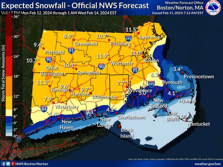
A new projected map of snowfall totals released Sunday, Feb. 11 by the National Weather Service is shown in the image above.
Boston is now expected to see around 11 inches of snowfall -- a big jump from the 6 inches predicted a day earlier.
In Connecticut, the most snowfall is expected in the northwestern part of the state, in Litchfield County, with about 11 inches of accumulation predicted.
Precipitation is expected to begin as rain Monday night before changing over to a wintry mix a few hours before daybreak on Tuesday, with snow, which could be heavy at times, in inland areas, where a Winter Storm Watch is now in effect from 1 a.m. to 6 p.m. Tuesday.
There will be a mix of sun and clouds on Monday, with a high temperature in the mid-40s.
With the low temperature expected to drop to just below the freezing mark overnight into Tuesday, a widespread mix of rain, sleet, and snow is expected from the system, with mainly snow, heavy at times.
Wind gusts could be as high as 30 to 40 miles per hour during the height of the storm on Tuesday.
The current outlook for Valentine's Day on Wednesday, Feb. 14 calls for mostly sunny skies and a high temperature in the low to mid-30s.
Check back to Daily Voice for updates.
Click here to follow Daily Voice Lynn and receive free news updates.
