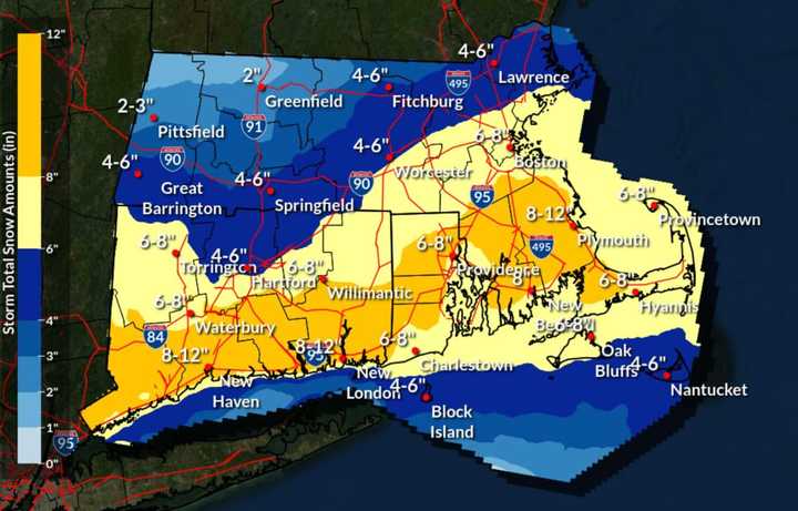
According to the latest prediction models, the northwestern portion of the state is now expected to receive to up 3 inches of snow, with a band running from the west through Springfield and up to Lawrence getting as much as 6 inches, according to forecasters. Worcester and Boston could receive 6 to 8 inches.
Connecticut and portions of the coast of southeast Massachusetts will receive the worst of the nor'easter with as much as a foot of snow predicted to fall. All of those totals are down from earlier predictions, and they could continue to drop if the storm shifts further south.
Precipitation is expected to begin as rain Monday night, with snowfall beginning Tuesday morning.
Massachusetts Gov. Maura Healey said Bay Staters should be proactive and prepare for potential service outages. Her office released steps residents should take to help them weather the storm.
Clear snow and ice from your vehicle’s windows, lights, hood, and roof before driving. Utilize safe winter driving practices, including leaving extra room for braking and stopping in slippery travel conditions. Don't crowd the plow or maintenance vehicles. Stay back at least 200 feet and don't pass on the right. Prepare for possible power outages. Fully charge your cellphone, laptop, and any essential electronic devices before the storm. Ensure you have extra batteries for medical equipment and assistive devices. Take stock of your emergency kit and ensure it includes seasonal supplies, such as extra winter clothing and blankets.
On top of the snow, forecasters have said wind gusts could reach up to 40 mph on Cape Cod.
Click here to follow Daily Voice Worcester and receive free news updates.
